FAA INFORMATION EFFECTIVE 14 MAY 2026
Location
| FAA Identifier: | 54J |
| Lat/Long: | 30-43-52.0000N 086-09-13.6000W
30-43.866667N 086-09.226667W
30.7311111,-86.1537778
(estimated) |
| Elevation: | 289.1 ft. / 88.1 m (surveyed) |
| Variation: | 04W (2020) |
| From city: | 2 miles W of DEFUNIAK SPRINGS, FL |
| Time zone: | UTC -5 (UTC -6 during Standard Time) |
| Zip code: | 32433 |
Airport Operations
| Airport use: | Open to the public |
| Activation date: | 04/1946 |
| Control tower: | no |
| ARTCC: | JACKSONVILLE CENTER |
| FSS: | GAINESVILLE FLIGHT SERVICE STATION |
| NOTAMs facility: | GNV (NOTAM-D service available) |
| Attendance: | MON-FRI 0900-1600 |
| Wind indicator: | lighted |
| Segmented circle: | yes |
| Lights: | ACTVT PAPI RWY 9 & 27; MIRL RWY 09/27 - CTAF. |
| Beacon: | white-green (lighted land airport)
Operates sunset to sunrise. |
Airport Communications
| CTAF/UNICOM: | 123.05 |
| WX AWOS-3P: | 118.725 (850-892-0147) |
| EGLIN APPROACH: | 124.05 |
| EGLIN DEPARTURE: | 124.05 |
| WX ASOS at CEW (19 nm W): | 119.275 (850-682-1237) |
- IFR CLEARANCE CTC EGLIN RAPCON 850-882-9151 PRIOR TO DEPARTURE.
Nearby radio navigation aids
| VOR radial/distance | | VOR name | | Freq | | Var |
|---|
| CEWr099/27.7 | | CRESTVIEW VORTAC | | 115.90 | | 03E |
| EDNr204/(36.3) | | ENTERPRISE VOR | | 116.60 | | 03W |
| OZRr217/39.0 | | CAIRNS VOR/DME | | 111.20 | | 03W |
| NDB name | | Hdg/Dist | | Freq | | Var | | ID |
|---|
| BOLL WEEVIL | | 197/37.6 | | 352 | | 03W | | BVG | -... ...- --. |
Airport Services
| Fuel available: | 100LL JET-A+
100LL:FUEL 24 HR CREDIT CARD SVC AVBL. |
| Parking: | tiedowns |
| Airframe service: | MAJOR |
| Powerplant service: | MAJOR |
| Bottled oxygen: | NONE |
| Bulk oxygen: | NONE |
Runway Information
Runway 9/27
| Dimensions: | 4146 x 60 ft. / 1264 x 18 m |
| Surface: | asphalt, in fair condition |
| Weight bearing capacity: | | PCN 6 /F/A/X/T | | Single wheel: | 20.0 |
|
| Runway edge lights: | medium intensity |
| RUNWAY 9 | | RUNWAY 27 |
| Latitude: | 30-43.959072N | | 30-43.954462N |
| Longitude: | 086-09.645487W | | 086-08.853705W |
| Elevation: | 283.6 ft. | | 278.0 ft. |
| Traffic pattern: | left | | left |
| Runway heading: | 094 magnetic, 090 true | | 274 magnetic, 270 true |
| Displaced threshold: | no | | 605 ft. |
| Markings: | nonprecision, in fair condition | | nonprecision, in fair condition |
| Visual slope indicator: | 2-light PAPI on left (3.00 degrees glide path) | | 2-light PAPI on left (3.00 degrees glide path) |
| Touchdown point: | yes, no lights | | yes, no lights |
| Obstructions: | 6 ft. fence, 200 ft. from runway, 165 ft. right of centerline
FENCE 6FT TALL, 200 FT BFR AER, 160 FT RIGHT OF CNTRLN. | | 28 ft. rr, 475 ft. from runway, 250 ft. right of centerline, 9:1 slope to clear
RWY 27 APCH SLOPE 24:1 TO DTHR. |
Runway 18/36
| Dimensions: | 2700 x 60 ft. / 823 x 18 m |
| Surface: | dirt, in fair condition |
| Runway edge markings: | WHITE PVC PIPE EVERY 200 FT. |
| RUNWAY 18 | | RUNWAY 36 |
| Latitude: | 30-43.952010N | | 30-43.506615N |
| Longitude: | 086-09.189832W | | 086-09.194603W |
| Elevation: | 282.1 ft. | | 268.7 ft. |
| Traffic pattern: | left | | left |
| Runway heading: | 185 magnetic, 181 true | | 005 magnetic, 001 true |
| Displaced threshold: | 165 ft. | | 400 ft. |
| Markings: | NSTD, in fair condition | | NSTD, in fair condition |
| Obstructions: | 34 ft. pline, 933 ft. from runway, 75 ft. left of centerline, 28:1 slope to clear | | 26 ft. trees, 1280 ft. from runway, 105 ft. right of centerline |
Airport Ownership and Management from official FAA records
| Ownership: | Publicly-owned |
| Owner: | CITY OF DE FUNIAK SPRINGS
P.O. BOX 685
DEFUNIAK SPRINGS, FL 32435-0685
Phone 850-892-8500
CTC PERSON KOBY TOWNSEND 850-892-8500 FAX: 850-892-6575. |
| Manager: | ANDRE LEWIS-KENT
1931 US HIGHWAY 90 W
DE FUNIAK SPRINGS, FL 32435
Phone 850-892-2000 |
Additional Remarks
| A30A-09 | UNLGTD FENCE & RD 160 FT S OF CNTRLN PENETRATES APCH SFC. |
| - | TREES OBST LN OF SIGHT BTN RWY 09 & 36 AND RWY 27 & 36. RWY 09 & 27 LN OF SIGHT OBST DUE TO RWY 09 UP SLOPE. |
| - | RWY SAFETY AREA E OF RWY 18/36. |
Instrument Procedures
NOTE: All procedures below are presented as PDF files. If you need a reader for these files, you should download the free Adobe Reader.NOT FOR NAVIGATION. Please procure official charts for flight.
FAA instrument procedures published for use from 14 May 2026 at 0901Z to 11 June 2026 at 0900Z.
IAPs - Instrument Approach Procedures |
|---|
| RNAV (GPS) RWY 09 | |
download (214KB) |
| RNAV (GPS) RWY 27 | |
download (190KB) |
| NOTE: Special Alternate Minimums apply | |
download (140KB) |
| NOTE: Special Take-Off Minimums/Departure Procedures apply | |
download (162KB) |
Other nearby airports with instrument procedures:
KCEW - Bob Sikes Airport (19 nm W)
KEGI - Duke Field (Eglin AF Aux Nr 3) Airport (20 nm W)
0J4 - Florala Municipal Airport (20 nm NW)
33J - Geneva Municipal Airport (24 nm NE)
KVPS - Eglin Air Force Base/Destin-Fort Walton Beach Airport (24 nm SW)
|
|

Road maps at:
MapQuest
Bing
Google
| Aerial photo |
|---|
WARNING: Photo may not be current or correct
 Photo by Lee Prestwood
Taken in August 2012
looking west.
Photo by Lee Prestwood
Taken in August 2012
looking west.
Do you have a better or more recent aerial photo of DeFuniak Springs Airport that you would like to share? If so, please send us your photo.
|
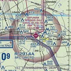
| Sectional chart |
|---|
|
CAUTION: Diagram may not be current

| Airport distance calculator |
|---|
|
|
| Sunrise and sunset |
|---|
|
Times for 25-May-2026
| | Local
(UTC-5) | | Zulu
(UTC) |
|---|
| Morning civil twilight | | 05:19 | | 10:19 |
| Sunrise | | 05:46 | | 10:46 |
| Sunset | | 19:38 | | 00:38 |
| Evening civil twilight | | 20:05 | | 01:05 |
|
| Current date and time |
|---|
| Zulu (UTC) | 26-May-2026 03:11:25 |
|---|
| Local (UTC-5) | 25-May-2026 22:11:25 |
|---|
|
| METAR |
|---|
| K54J | 260255Z AUTO 10008KT 10SM -RA SCT005 SCT025 OVC110 21/21 A2999 RMK AO2 P0013 6//// T02060206
|
KCEW
19nm W | 260253Z AUTO 23003KT 10SM CLR 21/20 A3001 RMK AO2 RAE14 SLP160 P0000 60003 T02110200 53014
|
|
| NOTAMs |
|---|
NOTAMs are issued by the DoD/FAA and will open in a separate window not controlled by AirNav.
|
|


