FAA INFORMATION EFFECTIVE 14 MAY 2026
Location
| FAA Identifier: | EGI |
| Lat/Long: | 30-38-54.9130N 086-31-19.0537W
30-38.915217N 086-31.317562W
30.6485869,-86.5219594
(estimated) |
| Elevation: | 195.3 ft. / 59.5 m (surveyed) |
| Variation: | 03W (2020) |
| From city: | 3 miles W of CRESTVIEW, FL |
| Time zone: | UTC -5 (UTC -6 during Standard Time) |
| Zip code: | 32578 |
Airport Operations
| Airport use: | Private use. Permission required prior to landing |
| Control tower: | yes |
| ARTCC: | JACKSONVILLE CENTER |
| FSS: | GAINESVILLE FLIGHT SERVICE STATION |
| NOTAMs facility: | GNV (NOTAM-D service available) |
| Attendance: | MON-FRI 1445-0600Z++
CLSD WKEND AND HOL. BASE OPS/ATC NOT MANNED OT. |
| Wind indicator: | yes |
| Segmented circle: | no |
| Lights: | SS-SR |
| Beacon: | white-white-green (lighted military airport)
ROTG BCN OTS SS-SR. Operates sunset to sunrise. |
Airport Communications
| ATIS: | 244.575 |
| DUKE GROUND: | 123.25 251.125 [1445-0600Z++ MON-FRI EXC HOL, OT SEE FAR PART 93.83 SPECIAL AIR TRAFFIC RULES.] |
| DUKE TOWER: | 133.2 290.425 [1445-0600Z++ MON-FRI EXC HOL, OT SEE FAR PART 93.83 SPECIAL AIR TRAFFIC RULES.] |
| EGLIN APPROACH: | 125.1 ;271-089 132.1 ;090-270 |
| EGLIN DEPARTURE: | 124.05 |
| COMD POST: | 138.437 225.75 |
| EMERG: | 121.5 |
| PMSV METRO: | 342.2 |
| PTD: | 372.2 |
| WX ASOS at CEW (8 nm N): | 119.275 (850-682-1237) |
| WX ASOS at DTS (15 nm S): | 133.925 (850-654-7128) |
| WX AWOS-3P at 54J (20 nm E): | 118.725 (850-892-0147) |
- UHF EQUIP ACFT MUST USE UHF (NOT VHF) IN DUKE TFC PATTERN.
- UHF EQPT ACFT MUST USE UHF IN DUKE TFC PAT.
Nearby radio navigation aids
| VOR radial/distance | | VOR name | | Freq | | Var |
|---|
| CEWr140/13.4 | | CRESTVIEW VORTAC | | 115.90 | | 03E |
| NDB name | | Hdg/Dist | | Freq | | Var | | ID |
|---|
| KOBRA | | 180/12.3 | | 201 | | 04W | | CE | -.-. . |
Airport Services
| Airframe service: | NONE |
| Powerplant service: | NONE |
| Bottled oxygen: | NONE |
| Bulk oxygen: | LOW |
Runway Information
Runway 18/36
| Dimensions: | 8025 x 150 ft. / 2446 x 46 m |
| Surface: | asphalt/concrete
PEM: ASPH/CONC/MACADAM |
| Weight bearing capacity: | |
| Runway edge lights: | high intensity
RWY 18/36 NSTD HIRL EDGE LGTS LCTD 75 FT FROM OUTSIDE EDGE STRIPE. |
| RUNWAY 18 | | RUNWAY 36 |
| Latitude: | 30-39.683167N | | 30-38.359500N |
| Longitude: | 086-31.361167W | | 086-31.385833W |
| Elevation: | 189.2 ft. | | 190.4 ft. |
| Traffic pattern: | left | | left |
| Declared distances: | TORA:8026 TODA:8026 | | TORA:8026 TODA:8026 |
| Markings: | nonprecision, in good condition | | nonprecision, in good condition |
| Visual slope indicator: | 4-light PAPI on left (3.00 degrees glide path) | | 4-light PAPI on left (3.00 degrees glide path) |
| Approach lights: | ALSF1: standard 2,400 foot high intensity approach lighting system with centerline sequenced flashers (category I) | | SALSF |
| Runway end identifier lights: | no | | no |
| Touchdown point: | yes, no lights | | yes, no lights |
| Instrument approach: | LOC/GS | | |
Airport Ownership and Management from official FAA records
| Ownership: | U.S. Air Force |
| Owner: | USAF
DEPT OF THE AF, HQ ADTC
EGLIN AFB, FL 32542 |
| Manager: | DEPT OF THE AF, HQ ADTC
EGLIN AFB, FL 32542
Phone 904-882-2013
AIR TFC REP BASE OPS OFF TEL 904-882-3608. |
Additional Remarks
| E60-18 | TYPE-H BAK-12B(B) (1260') |
| E60-36 | TYPE-H BAK-12B(B) (1260') |
| - | TRAN ALERT: TRAN ALERT SVC PRVDD AT DUKE BY EGLIN AFB (KVPS) AND ONLY AVBL FOR APV 7TH SFG MSNS AND LCL (BASE ASGN) ACFT DEPLOYMENT MSNS. TACC OR UNITS SUPPORTING TRAN MSNS MUST COORD THE PPR REQUEST 7 DAYS IN ADVN OF ARR DATE TO ENSURE USE OF DUKE FIELD. UNITS SUPPORTING 7TH SFG MSNS MUST BRING CREW CHIEF FOR LCL RRBN FLTS. TRAN ACFT MUST USE FLW ME TO PRKG. TRAN ACFT NOT ALLOWED WHEN TRAN ALERT UNAVBL. TRAN ALERT WILL NOT SUPPORT ACFT AT EGI THAT UTILIZE KVPS AS THE INITIAL ARR LCTN. TRAN PRKG ROWS 9 & 11 RSTD TO TRAN ACFT ONLY. ROW 15 RESD FOR C-130 AND C-17 ONLY. FLEET SVC UNAVBL. |
| - | CSTMS/AG/IMG: LTD SVC, NO RESIDENT CSTMS AGENT. AVBL ONLY TO BASE ASGN ACFT AND 7TH SPECIAL FORCES GP (7 SFG) APVD MSN. 48 HR PN RQR. ALL OTHER ACFT MUST CLEAR CSTMS PRIOR TO ARR. |
| - | MISC: EXP NO NTC CLOSURE OF DUKE FLD AIRSPACE FOR SPECIAL MSN TEST. STD USAF RSRS APPLIED. BASE OPS DSN 875-6516, C850-883-6516, NML OPR WKD. |
| - | COMD POST: (CALL SANDCASTLE) DSN 875-6701, C850-883-6701 OR 1-800-437-8843. |
| - | MISC- WX OPR 1400-0600Z++. REMOTE BRIEFING AVBL 96 WS EGLIN AFB, DSN 872-4800, C850-882-4800. AFLD WX MNT BY AN/FMO-19 ASOS; AUGMENTED 1400-0600Z++ WKD, AUTOMATED 0600-1400Z++ MON-FRI AND H24 WKEND/HOL. AFLD VIS RSTD TO 1/8 SM TO SW AND 1/4 SM W THRU NW DUE TO MAIN BASE STRUCTURES; MAX SFC VIS MRK 1 SM (SE). NGT CLOUD COVER VIEWING RSTD DUE TO SFC LGT. |
| - | SERVICE-LGT: RWY 36 ALS NSTD (ONLY HIRL, THLD, PRE-THLD, AND TERM BAR AVBL). RWY 180 AND RWY 360 LZ NSTD AFLD MRK PAT (AMP) LGT CONFIGN FLASHING STROBE LIGHT(FSL) NOT ON CNTRLN. FSLS OFFSET 30 FT TO LEFT AT EACH END. RWY 18 PAPI RRP NOT COINCIDENTAL WITH ILS RPI. |
| - | CAUTION: HI VOLUME OF MIL TRNG ACFT NEAR CEW VORTAC AND IN VCNTY OF BOB SIKES ARPT. UNLGTD OBST ON AFLD. DUE TO LACK OF VISUAL REFERENCE DUR NGT VFR OPR, PILOT EFFORTS TO MAINT ALT BY VISUAL MEANS MAY BE UNREL. N END NSTD OVRN (554 FT X 150 FT). S END NSTD OVRN (556 FT X 150 FT). EXTV ALZ/NVD TRNG IN EFF WKD. |
| - | MISC: AFLD MOWING SEASON MAR-NOV. EXP INCREASED BIRD ACTIVITY INVOF MOWERS OPERATING ON AFLD. |
| - | CAUTION: DITCHES APPROX 1260 FT FROM LDG THLD EACH SIDE OF RWY ADJ TO BAK-12 A-GEAR (35 FT FROM RWY EDGE LINES) PRESENT HAZ COND IF DIREC CTL LOST DUR TKOF OR LDG PHASE OF FLT. |
| - | A-GEAR: RWY 18/36 A-GEAR RQR PN; CTC TWR. EXP DELAY OF TO 30 SEC FOR CABLE TO RAISE. DEP END A-GEAR RAISED BY TWR WHEN FTR ACFT IN PAT. EXP NO NOTICE RWY CLOSURE AFTER BAK-12 ENGAGEMENT (UP TO 2 HOURS). STD A-GEAR CONFIGN IS BOTH ENDS IN DOWN POSN. A-G UNAVBL, O/S OUTSIDE PUBLISHED HR, DUR WKENDS, AND NATL HOL (NOT INSPECTED OR CERTIFIED). |
| - | CAUTION: MANDATORY SIGNS AT TWYS C, D, E, AND F IMPROPERLY SITED; LCTD 60 FT FROM TWY EDGE. |
| - | RWY 18 AND RWY 36 OVERRUN SURFACES ARE ASPHALT. |
| - | TWY D NE OF THE APEX LTD TO CV-22 DUE TO TWY LATERAL OBST CLNC. THE HOT PIT FUEL LANES EAST OF APEX CLSD TO ALL ACFT DUE TO TWY LATERAL OBST CLNC |
| - | FUEL: A++ |
| - | JASU: (AM32A-95) (B-809) |
| - | FLUID: PRESAIR, OIL, LOX, AND SOAP/JOAP UNAVBL. |
| - | RSTD: OFFL BUS ONLY. PRACTICE APP AND TOUCH AND GO OPS RSTD TO 919 SOW, 492 SOW, 96 TW, 33 FW AND AFSOC ASGN ACFT ONLY. LCL ACFT REQ PAX PICKUP AND/OR DROP OFF AT AM OPS RQR PRIOR COORD WITH AFLD MGMT. TAXI TRNG FOR BASE ASGN ACFT MUST BE ACCOMPLISHED ON TWY D EAST, TWY F EAST, VERTICAL LAND NORTH, VERTICAL LAND SOUTH EAST OF THE ASSAULT LDG ZONE (LZ). NO C-5 ACFT ON TWY A NORTH OF MAIN RAMP. TWYS D EAST AND F HAVE WT RSTRN FOR C-17 ACFT; SEE ASRR AND CTC AFLD MGMT. CDDAR SVC LMTD AND BASED OUT OF KVPS. TRAN AIRCREW SUPPORTING 7TH SFG AIRBORNE OPS MUST OBTAIN LCL AREA RANGE ORIENTATION BRFG; CTC 7TH SFG S3 AIR OPS, C850-885-7305. LDG ZONE (LZ) RSTD FOR USE BY 919 SOW, 492 SOW, 96 TW AND AFSOC ASGN ACFT ONLY. NO DAYTIME VISUAL LDG ZONE MKR PANELS AVBL ON LDG ZONE (LZ). 180 DEG TURNS ON RWY 180/360 LZ LMTD TO U-28, PC-12, C-145, C-146 AND C-208 ACFT. 180 DEG TURNS UNAUTH ON RWY 18/36. |
| - | ARFF COND FOR DUKE FLD IS OPTIMUM LEVEL OF SVC (OLS) FOR CATS 1-2 AND REDUCED LEVEL OF SVC (RLS) FOR CAT 3-6, 7600 GAL AVBL. |
| - | COMMUNICATIONS: PMSV METRO - 377.625. NO SVC OUTSIDE AFLD OPR HRS - CTC CMD POST. |
| - | PRKG ROW 9 RSTRD TO C208 ACFT ONLY. |
| - | USE CAUTION FOR UAS OPS IN VCNTY OF DUKE FLD. |
Instrument Procedures
NOTE: All procedures below are presented as PDF files. If you need a reader for these files, you should download the free Adobe Reader.NOT FOR NAVIGATION. Please procure official charts for flight.
FAA instrument procedures published for use from 14 May 2026 at 0901Z to 11 June 2026 at 0900Z.
Other nearby airports with instrument procedures:
KCEW - Bob Sikes Airport (8 nm N)
KVPS - Eglin Air Force Base/Destin-Fort Walton Beach Airport (10 nm S)
KDTS - Destin Executive Airport (15 nm S)
KHRT - Hurlburt Field Airport (16 nm SW)
54J - DeFuniak Springs Airport (20 nm E)
|
|

Road maps at:
MapQuest
Bing
Google
| Aerial photo |
|---|
WARNING: Photo may not be current or correct
 Photo by Scott Jackson PhotosFlorida.com
Photo taken 15-Apr-2006
Photo by Scott Jackson PhotosFlorida.com
Photo taken 15-Apr-2006
Do you have a better or more recent aerial photo of Duke Field (Eglin AF Aux Nr 3) Airport that you would like to share? If so, please send us your photo.
|
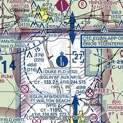
| Sectional chart |
|---|
|
 Download PDF
of official airport diagram from the FAA
| Airport distance calculator |
|---|
|
|
| Sunrise and sunset |
|---|
|
Times for 01-Jun-2026
| | Local
(UTC-5) | | Zulu
(UTC) |
|---|
| Morning civil twilight | | 05:18 | | 10:18 |
| Sunrise | | 05:45 | | 10:45 |
| Sunset | | 19:43 | | 00:43 |
| Evening civil twilight | | 20:10 | | 01:10 |
|
| Current date and time |
|---|
| Zulu (UTC) | 01-Jun-2026 13:53:03 |
|---|
| Local (UTC-5) | 01-Jun-2026 08:53:03 |
|---|
|
| METAR |
|---|
| KEGI | 011329Z AUTO 27009KT 10SM SCT015 BKN021 29/25 A3000 RMK AO2 BKN V SCT SLP158 $
|
KCEW
7nm N | 011253Z AUTO 27005KT 8SM FEW015 27/25 A3003 RMK AO2 SLP164 T02670250
|
KVPS
11nm S | 011255Z AUTO 25004KT 10SM CLR 27/27 A2999 RMK AO2 SLP162 P0000 T02740268 $
|
KDTS
15nm S | 011253Z VRB04KT 10SM CLR 28/25 A2999 RMK AO2 SLP155 T02830250
|
KHRT
16nm SW | 011255Z 26006KT 10SM FEW012 FEW020 29/25 A2998 RMK AO2A SLP150 T02860252 $
|
K54J
20nm E | 011335Z AUTO 27006KT 10SM BKN008 BKN014 BKN025 27/26 A3002 RMK AO2 T02700262
|
|
| TAF |
|---|
KVPS
11nm S | 010900Z 0109/0215 23006KT 9999 FEW015 SCT050 BKN100 QNH2997INS BECMG 0115/0116 26009KT 9999 SCT030 QNH2998INS TEMPO 0116/0120 8000 -SHRA BKN010 BECMG 0121/0122 25009KT 9999 SCT025 BKN050 QNH2997INS BECMG 0203/0204 26006KT 9000 -SHRA BKN015 QNH2996INS BECMG 0206/0207 27006KT 8000 -SHRA BR BKN008 OVC015 QNH2997INS TX30/0118Z TN24/0111Z
|
KHRT
16nm SW | 011200Z 0112/0216 VRB06KT 9999 VCSH SCT020 QNH2993INS TEMPO 0112/0114 BKN015 BECMG 0113/0114 22009KT 9999 NSW SCT020 QNH2989INS TEMPO 0120/0123 VRB15G25KT 4800 -TSRA BKN020CB BKN060 BECMG 0201/0202 VRB06KT 9999 SCT020 BKN030 QNH2990INS BECMG 0206/0207 VRB06KT 4800 BR BKN008 QNH2991INS BECMG 0211/0212 VRB06KT 9999 NSW SCT015 QNH2992INS TEMPO 0215/0216 VRB15G25KT 6000 -TSRA BKN020CB TX30/0120Z TN26/0112Z
|
|
| NOTAMs |
|---|
NOTAMs are issued by the DoD/FAA and will open in a separate window not controlled by AirNav.
|
|


