FAA INFORMATION EFFECTIVE 27 NOVEMBER 2025
Location
| FAA Identifier: | DTS |
| Lat/Long: | 30-24-00.1970N 086-28-17.3000W
30-24.003283N 086-28.288333W
30.4000547,-86.4714722
(estimated) |
| Elevation: | 22.6 ft. / 6.9 m (surveyed) |
| Variation: | 01W (2000) |
| From city: | 1 mile E of DESTIN, FL |
| Time zone: | UTC -6 (UTC -5 during Daylight Saving Time) |
| Zip code: | 32541 |
Airport Operations
| Airport use: | Open to the public |
| Activation date: | 02/1965 |
| Control tower: | yes |
| ARTCC: | JACKSONVILLE CENTER |
| FSS: | GAINESVILLE FLIGHT SERVICE STATION |
| NOTAMs facility: | DTS (NOTAM-D service available) |
| Attendance: | 0600-2200 |
| Wind indicator: | lighted |
| Segmented circle: | yes |
| Lights: | ACTVT PAPI RWY 14 & 32; HIRL RWY 14/32 - CTAF. |
| Beacon: | white-green (lighted land airport)
Operates sunset to sunrise. |
Airport Communications
| CTAF: | 118.45 |
| ATIS: | 133.925 |
| WX ASOS: | 133.925 (850-654-7128) |
| DESTIN GROUND: | 121.6 [0600-2200] |
| DESTIN TOWER: | 118.45 [0600-2200] |
| EGLIN APPROACH: | 132.1 |
| EGLIN DEPARTURE: | 132.1 |
| CLEARANCE DELIVERY: | 121.6 127.7 ;WHEN TWR CLSD |
- CLASS D SVCS PRVDD BY EGLIN APCH WHEN DESTIN ATCT CLSD.
Nearby radio navigation aids
| VOR radial/distance | | VOR name | | Freq | | Var |
|---|
| CEWr154/27.7 | | CRESTVIEW VORTAC | | 115.90 | | 03E |
Airport Services
| Fuel available: | 100LL JET-A |
| Parking: | tiedowns |
| Airframe service: | MAJOR |
| Powerplant service: | MAJOR |
| Bottled oxygen: | HIGH |
| Bulk oxygen: | HIGH/LOW |
Runway Information
Runway 14/32
| Dimensions: | 5001 x 100 ft. / 1524 x 30 m |
| Surface: | asphalt, in good condition |
| Weight bearing capacity: | | PCN 25 /F/B/W/T | | Single wheel: | 38.0 | | Double wheel: | 67.0 | | Double tandem: | 113.0 |
|
| Runway edge lights: | high intensity |
| RUNWAY 14 | | RUNWAY 32 |
| Latitude: | 30-24.328927N | | 30-23.677627N |
| Longitude: | 086-28.580440W | | 086-27.996263W |
| Elevation: | 22.2 ft. | | 21.0 ft. |
| Traffic pattern: | left | | left |
| Runway heading: | 143 magnetic, 142 true | | 323 magnetic, 322 true |
| Markings: | nonprecision, in good condition | | nonprecision, in good condition |
| Visual slope indicator: | 4-light PAPI on left (3.00 degrees glide path)
RWY 14 PAPI UNA BYD 6 DEG L OF RCL. | | 4-light PAPI on left (3.00 degrees glide path)
RWY 32 PAPI UNUSABLE BEYOND 7 DEGREES LEFT AND RIGHT OF CNTRLN. |
| Touchdown point: | yes, no lights | | yes, no lights |
| Obstructions: | 37 ft. trees, 1485 ft. from runway, 100 ft. left of centerline, 34:1 slope to clear | | 117 ft. bldg, lighted, 4880 ft. from runway, 325 ft. right of centerline, 40:1 slope to clear |
Airport Ownership and Management from official FAA records
| Ownership: | Publicly-owned |
| Owner: | OKALOOSA CO
BOARD OF COMMISSIONERS, 302 N. WILSON ST. - SUITE 302
CRESTVIEW, FL 32536
Phone 850-689-5000 |
| Manager: | TRACY STAGE
1701 STATE ROAD 85 NORTH
EGLIN AFB, FL 32542-1413
Phone 850-651-7160
EXT 4 |
Additional Remarks
| - | EXERCISE VIGILANCE DUE TO CLOSE PROXIMITY TO EGLIN AFB LCTD 6 NM NW. |
| - | ALL ACFT CTC EGLIN CD ON 127.7 FOR ATC DEP INSTR PRIOR TO TKOF WHEN TWR CLSD. |
| - | WHEN TWR CLSD; IFR ACFT RMN ON GND & CTC DEP CTL FOR CLIMB OUT INSTR & IFR RLS. |
| - | ARPT COND UNMON. |
| - | PARASAILING & BANNER TOWING WI 5 NM. |
| - | CAUTION: MEN & EQUIP ON & INVOF SAFETY AREA. |
| - | FOR FBO SERVICES CONTACT 130.05. |
Instrument Procedures
NOTE: All procedures below are presented as PDF files. If you need a reader for these files, you should download the free Adobe Reader.NOT FOR NAVIGATION. Please procure official charts for flight.
FAA instrument procedures published for use from 27 November 2025 at 0901Z to 25 December 2025 at 0900Z.
IAPs - Instrument Approach Procedures |
|---|
| RNAV (GPS) RWY 14 | |
download (264KB) |
| RNAV (GPS) RWY 32 | |
download (252KB) |
| NOTE: Special Alternate Minimums apply | |
download (123KB) |
| NOTE: Special Take-Off Minimums/Departure Procedures apply | |
download (408KB) |
Other nearby airports with instrument procedures:
KVPS - Eglin Air Force Base/Destin-Fort Walton Beach Airport (6 nm NW)
KHRT - Hurlburt Field Airport (11 nm W)
KEGI - Duke Field (Eglin AF Aux Nr 3) Airport (15 nm N)
KCEW - Bob Sikes Airport (23 nm N)
54J - DeFuniak Springs Airport (26 nm NE)
|
|

Road maps at:
MapQuest
Bing
Google
| Aerial photo |
|---|
WARNING: Photo may not be current or correct
 Photo by David W. Oehler
Photo taken 03-Mar-2017
looking northwest.
Photo by David W. Oehler
Photo taken 03-Mar-2017
looking northwest.
Do you have a better or more recent aerial photo of Destin Executive Airport that you would like to share? If so, please send us your photo.
|
| Sectional chart |
|---|
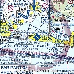
|
| Airport distance calculator |
|---|
|
|
| Sunrise and sunset |
|---|
|
Times for 07-Dec-2025
| | Local
(UTC-6) | | Zulu
(UTC) |
|---|
| Morning civil twilight | | 06:04 | | 12:04 |
| Sunrise | | 06:31 | | 12:31 |
| Sunset | | 16:44 | | 22:44 |
| Evening civil twilight | | 17:10 | | 23:10 |
|
| Current date and time |
|---|
| Zulu (UTC) | 07-Dec-2025 17:14:20 |
|---|
| Local (UTC-6) | 07-Dec-2025 11:14:20 |
|---|
|
| METAR |
|---|
| KDTS | 071700Z 06005KT 6SM RA BR SCT004 BKN049 OVC070 13/12 A3000 RMK AO2 P0001 T01280122 $
|
KVPS
5nm NW | 071655Z AUTO 05005KT 6SM +RA BR SCT005 OVC019 13/13 A2999 RMK AO2 CIG 006V019 CIG 003 RWY12 SLP163 P0004 T01310126 $
|
KHRT
10nm W | 071655Z 08006KT 9SM RA BKN006 BKN020 OVC050 13/12 A2998 RMK AO2A SLP150 P0010 T01320121 $
|
KEGI
14nm N | 071655Z AUTO 08005KT 7SM RA OVC002 12/12 A2999 RMK AO2 SLP157 P0011 T01240115 $
|
|
| TAF |
|---|
KVPS
5nm NW | 070900Z 0709/0815 06009KT 9000 -SHRA SCT005 BKN015 QNH3000INS BECMG 0802/0803 07009KT 9999 NSW SCT018 QNH2998INS TX13/0712Z TN11/0806Z
|
KHRT
10nm W | 071200Z 0712/0816 07009KT 9000 -SHRA BKN007 OVC020 510009 QNH2991INS TEMPO 0712/0723 BKN004 BECMG 0722/0723 03006KT 9999 NSW BKN009 510009 QNH2993INS BECMG 0808/0809 01010G20KT 8000 -SHRA SCT007 BKN015 510004 QNH2997INS BECMG 0812/0813 36012G24KT 9999 NSW SCT010 QNH3004INS TX13/0720Z TN10/0810Z
|
|
| NOTAMs |
|---|
NOTAMs are issued by the DoD/FAA and will open in a separate window not controlled by AirNav.
|
|


