FAA INFORMATION EFFECTIVE 22 JANUARY 2026
Location
| FAA Identifier: | 59M |
| Lat/Long: | 45-03-17.5271N 085-21-24.8279W
45-03.292118N 085-21.413798W
45.0548686,-85.3568966
(estimated) |
| Elevation: | 640 ft. / 195.1 m (surveyed) |
| Variation: | 04W (1985) |
| From city: | 3 miles S of EASTPORT, MI |
| Time zone: | UTC -5 (UTC -4 during Daylight Saving Time) |
| Zip code: | 49648 |
Airport Operations
| Airport use: | Open to the public |
| Activation date: | 11/1991 |
| Control tower: | no |
| ARTCC: | MINNEAPOLIS CENTER |
| FSS: | LANSING FLIGHT SERVICE STATION |
| NOTAMs facility: | LAN (NOTAM-D service available) |
| Attendance: | UNATNDD |
| Wind indicator: | yes |
| Segmented circle: | yes |
Airport Communications
| CTAF: | 122.9 |
| WX AWOS-3P at ACB (8 nm SE): | 119.275 (231-533-8941) |
| WX AWOS-3P at CVX (15 nm N): | 120.0 (231-237-9703) |
| WX AWOS-3PT at BFA (19 nm E): | 118.675 (231-330-8677) |
Nearby radio navigation aids
| VOR radial/distance | | VOR name | | Freq | | Var |
|---|
| TVCr021/24.6 | | TRAVERSE CITY VOR/DME | | 114.60 | | 02W |
| GLRr281/27.8 | | GAYLORD VOR/DME | | 109.20 | | 06W |
| CGGr316/(34.9) | | GRAYLING VOR | | 109.80 | | 06W |
| NDB name | | Hdg/Dist | | Freq | | Var | | ID |
|---|
| GRAYLING | | 315/29.0 | | 359 | | 06W | | GYG | --. -.-- --. |
Airport Services
Runway Information
Runway 9/27
| Dimensions: | 3300 x 100 ft. / 1006 x 30 m |
| Surface: | turf, in fair condition
UNEVEN ROLLING TRRN. |
| Runway edge markings: | RWY & DTHR MKD WITH 3 FT YELLOW CONES. |
| RUNWAY 9 | | RUNWAY 27 |
| Latitude: | 45-03.356500N | | 45-03.357000N |
| Longitude: | 085-21.806167W | | 085-21.040167W |
| Elevation: | 640.0 ft. | | 640.0 ft. |
| Traffic pattern: | left | | left |
| Runway heading: | 094 magnetic, 090 true | | 274 magnetic, 270 true |
| Displaced threshold: | no | | 1500 ft. |
| Obstructions: | 15 ft. road, 110 ft. left of centerline, 1:1 slope to clear | | 15 ft. road, 125 ft. right of centerline, 1:1 slope to clear
APCH RATIO 8:1 TO DTHR OVR 80 FT TREES, 658 FT DIST, 163 FT L. |
Runway 4/22
| Dimensions: | 2400 x 100 ft. / 732 x 30 m |
| Surface: | turf, in fair condition |
| Runway edge markings: | RWY & DTHR MKD WITH 3 FT YELLOW CONES. |
| RUNWAY 4 | | RUNWAY 22 |
| Latitude: | 45-03.034833N | | 45-03.371667N |
| Longitude: | 085-21.546833W | | 085-21.255000W |
| Elevation: | 632.0 ft. | | 627.0 ft. |
| Traffic pattern: | left | | left |
| Runway heading: | 036 magnetic, 032 true | | 216 magnetic, 212 true |
| Displaced threshold: | 400 ft. | | 600 ft. |
| Obstructions: | 64 ft. tree, 358 ft. from runway, 150 ft. right of centerline, 5:1 slope to clear
APCH RATIO 1:1 TO DTHR OVR 28 FT TREE, 17 FT DIST, 90 FT L. | | 15 ft. road, 15 ft. from runway, 125 ft. right of centerline, 1:1 slope to clear
APCH RATIO 3:1 TO DTHR OVR 72 FT TREES, 236 FT DIST, 135 FT L. |
Airport Ownership and Management from official FAA records
| Ownership: | Privately-owned |
| Owner: | TIMOTHY BAISE
118 W GRAND RIVER AVE
WILLIAMSTON, MI 48895-1318
Phone 517-420-3684
ARPT PHYS ADS: 1309 N US-31, KEWADIN, MI 49648. |
| Manager: | TIMOTHY BAISE
118 W GRAND RIVER AVE
WILLIAMSTON, MI 48895-1318
Phone 517-420-3684 |
Additional Remarks
| - | ARPT CLSD NOV 15-APR 15 & WHEN SNOW COVD EXC FOR SKI EQUIPPED ACFT. NO SNOW REMOVAL. |
| - | TREES OBSC VIEW OF RWY ENDS. |
| - | FOR CD CTC MINNEAPOLIS ARTCC AT 651-463-5588. |
| - | DEER, BIRDS, & WILDLIFE ON & INVOF ARPT. |
Instrument Procedures
There are no published instrument procedures at 59M.
Some nearby airports with instrument procedures:
KACB - Antrim County Airport (8 nm SE)
KCVX - Charlevoix Municipal Airport (15 nm N)
N98 - Boyne City Municipal Airport (18 nm NE)
KBFA - Boyne Mountain Airport (19 nm E)
KTVC - Cherry Capital Airport (21 nm SW)
|
|

Road maps at:
MapQuest
Bing
Google
| Aerial photo |
|---|
WARNING: Photo may not be current or correct

Do you have a better or more recent aerial photo of Torchport Airport that you would like to share? If so, please send us your photo.
|
| Sectional chart |
|---|
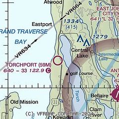
|
| Airport distance calculator |
|---|
|
|
| Sunrise and sunset |
|---|
|
Times for 23-Jan-2026
| | Local
(UTC-5) | | Zulu
(UTC) |
|---|
| Morning civil twilight | | 07:40 | | 12:40 |
| Sunrise | | 08:12 | | 13:12 |
| Sunset | | 17:35 | | 22:35 |
| Evening civil twilight | | 18:07 | | 23:07 |
|
| Current date and time |
|---|
| Zulu (UTC) | 24-Jan-2026 03:43:20 |
|---|
| Local (UTC-5) | 23-Jan-2026 22:43:20 |
|---|
|
| METAR |
|---|
KACB
8nm SE | 230915Z AUTO 30008G15KT 230V330 2SM -SN BKN017 OVC025 M18/M23 A3023 RMK AO2 VIS 1V4 T11761231
|
KCVX
15nm N | 240315Z AUTO 29013KT 3SM -SN HZ OVC023 M16/M19 A3058 RMK AO2
|
KBFA
19nm E | 240315Z AUTO 24005KT 1SM -SN BR BKN004 BKN008 OVC018 M16/M19 A3058 RMK AO2
|
|
| TAF |
|---|
KTVC
21nm SW | 231740Z 2318/2418 28013G23KT 1SM -SHSN BLSN BKN022 TEMPO 2318/2322 1/2SM SHSN BLSN VV009 FM240000 28007G17KT 2SM -SHSN BR BKN024 FM240300 29005KT 4SM -SHSN BKN025 FM240900 VRB03KT P6SM VCSH SCT025 BKN035 FM241700 24004KT P6SM VCSH BKN023
|
|
| NOTAMs |
|---|
NOTAMs are issued by the DoD/FAA and will open in a separate window not controlled by AirNav.
|
|

