FAA INFORMATION EFFECTIVE 16 APRIL 2026
Location
| FAA Identifier: | 5M0 |
| Lat/Long: | 34-24-29.6000N 086-55-58.6000W
34-24.493333N 086-55.976667W
34.4082222,-86.9329444
(estimated) |
| Elevation: | 628.5 ft. / 191.6 m (surveyed) |
| Variation: | 03W (2015) |
| From city: | 2 miles S of HARTSELLE, AL |
| Time zone: | UTC -5 (UTC -6 during Standard Time) |
| Zip code: | 35640 |
Airport Operations
| Airport use: | Open to the public |
| Activation date: | 09/1965 |
| Control tower: | no |
| ARTCC: | MEMPHIS CENTER |
| FSS: | ANNISTON FLIGHT SERVICE STATION |
| NOTAMs facility: | ANB (NOTAM-D service available) |
| Attendance: | 0800-1700 |
| Wind indicator: | lighted |
| Segmented circle: | yes |
| Lights: | ACTVT MIRL RY 18/36 & VASI RY 36 - CTAF. MIRL RY 18/36 PRESET HIGH INTST. |
| Beacon: | white-green (lighted land airport)
Operates sunset to sunrise. |
Airport Communications
| CTAF/UNICOM: | 122.8 |
| HUNTSVILLE APPROACH: | 118.05 |
| HUNTSVILLE DEPARTURE: | 118.05 |
| WX AWOS-3PT at CMD (9 nm SE): | 124.175 (256-775-7476) |
| WX ASOS at DCU (15 nm N): | 118.375 (256-350-4270) |
| WX ASOS at HSV (16 nm NE): | 121.25 (256-207-5925) |
- APCH/DEP SVC PRVDD BY MEMPHIS ARTCC ON FREQS 120.8/307.0 (HUNTSVILLE RCAG) WHEN HUNTSVILLE APCH CTL CLSD.
Nearby radio navigation aids
| VOR radial/distance | | VOR name | | Freq | | Var |
|---|
| RQZr210/27.6 | | ROCKET VORTAC | | 112.20 | | 02E |
Airport Services
| Fuel available: | 100LL |
| Parking: | hangars and tiedowns |
| Airframe service: | MAJOR |
| Powerplant service: | MAJOR |
| Bottled oxygen: | NONE |
| Bulk oxygen: | NONE |
Runway Information
Runway 18/36
| Dimensions: | 3599 x 75 ft. / 1097 x 23 m |
| Surface: | asphalt, in fair condition |
| Weight bearing capacity: | |
| Runway edge lights: | medium intensity |
| Runway edge markings: | ALL MKNGS OBSCD OR FADED |
| RUNWAY 18 | | RUNWAY 36 |
| Latitude: | 34-24.789957N | | 34-24.196670N |
| Longitude: | 086-55.972332W | | 086-55.981037W |
| Elevation: | 628.5 ft. | | 598.3 ft. |
| Traffic pattern: | left | | left |
| Runway heading: | 184 magnetic, 181 true | | 004 magnetic, 001 true |
| Markings: | nonprecision, in poor condition | | nonprecision, in poor condition |
| Visual slope indicator: | | | 2-box VASI on left (3.00 degrees glide path) |
| Touchdown point: | yes, no lights | | yes, no lights |
| Obstructions: | 26 ft. tree, 312 ft. from runway, 138 ft. left of centerline, 4:1 slope to clear | | 79 ft. tree, 1249 ft. from runway, 151 ft. left of centerline, 13:1 slope to clear |
Airport Ownership and Management from official FAA records
| Ownership: | Publicly-owned |
| Owner: | CITY OF HARTSELLE
200 SPARKMAN ST, NW
HARTSELLE, AL 35640
Phone 256-773-2535 |
| Manager: | STONEY POWELL
450 AIRPORT RD SW
HARTSELLE, AL 35640
Phone 256-773-1130
AFT HRS 256-303-2777. |
Additional Remarks
| - | FOR CD CTC HUNTSVILLE APCH AT 256-542-2070, WHEN APCH CLSD CTC MEMPHIS ARTCC AT 901-368-8453/8449. |
Instrument Procedures
NOTE: All procedures below are presented as PDF files. If you need a reader for these files, you should download the free Adobe Reader.NOT FOR NAVIGATION. Please procure official charts for flight.
FAA instrument procedures published for use from 16 April 2026 at 0901Z to 14 May 2026 at 0900Z.
IAPs - Instrument Approach Procedures |
|---|
| RNAV (GPS) RWY 18 **CHANGED** | |
download (200KB) |
| RNAV (GPS) RWY 36 **CHANGED** | |
download (196KB) |
| NOTE: Special Take-Off Minimums/Departure Procedures apply | |
download (488KB) |
Other nearby airports with instrument procedures:
KCMD - Cullman Regional Airport/Folsom Field (9 nm SE)
KDCU - Pryor Field Regional Airport (15 nm N)
KHSV - Huntsville International Airport-Carl T Jones Field (16 nm NE)
KHUA - Redstone Army Airfield (20 nm NE)
9A4 - Courtland Airport (25 nm NW)
|
|

Road maps at:
MapQuest
Bing
Google
| Aerial photo |
|---|
WARNING: Photo may not be current or correct
 Photo by Tom Weaver
Photo taken 23-Oct-2005
Photo by Tom Weaver
Photo taken 23-Oct-2005
Do you have a better or more recent aerial photo of Hartselle/Morgan County Regional Airport that you would like to share? If so, please send us your photo.
|
| Sectional chart |
|---|
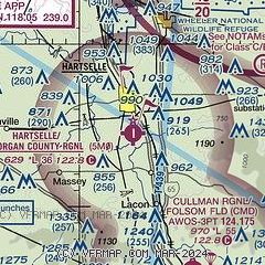
|
| Airport distance calculator |
|---|
|
|
| Sunrise and sunset |
|---|
|
Times for 10-May-2026
| | Local
(UTC-5) | | Zulu
(UTC) |
|---|
| Morning civil twilight | | 05:23 | | 10:23 |
| Sunrise | | 05:50 | | 10:50 |
| Sunset | | 19:38 | | 00:38 |
| Evening civil twilight | | 20:05 | | 01:05 |
|
| Current date and time |
|---|
| Zulu (UTC) | 10-May-2026 19:12:40 |
|---|
| Local (UTC-5) | 10-May-2026 14:12:40 |
|---|
|
| METAR |
|---|
KCMD
9nm SE | 101855Z AUTO 02005KT 10SM BKN047 BKN060 24/14 A3005 RMK AO2
|
KDCU
15nm N | 101853Z AUTO VRB03KT 10SM CLR 27/12 A3003 RMK AO2 SLP166 T02720122 $
|
KHSV
16nm NE | 101853Z 00000KT 10SM FEW048 SCT250 26/13 A3003 RMK AO2 SLP164 T02560133 $
|
|
| TAF |
|---|
KHSV
16nm NE | 101720Z 1018/1118 VRB04KT P6SM BKN045 FM111000 01007KT P6SM BKN070 PROB30 1110/1114 4SM -SHRA BR OVC025
|
|
| NOTAMs |
|---|
NOTAMs are issued by the DoD/FAA and will open in a separate window not controlled by AirNav.
|
|

