FAA INFORMATION EFFECTIVE 20 FEBRUARY 2025
Location
| FAA Identifier: | CMD |
| Lat/Long: | 34-16-07.3290N 086-51-28.9270W
34-16.122150N 086-51.482117W
34.2687025,-86.8580353
(estimated) |
| Elevation: | 969.6 ft. / 295.5 m (surveyed) |
| Variation: | 03W (2015) |
| From city: | 5 miles N of CULLMAN, AL |
| Time zone: | UTC -6 (UTC -5 during Daylight Saving Time) |
| Zip code: | 35179 |
Airport Operations
| Airport use: | Open to the public |
| Activation date: | 12/1958 |
| Control tower: | no |
| ARTCC: | MEMPHIS CENTER |
| FSS: | ANNISTON FLIGHT SERVICE STATION |
| NOTAMs facility: | CMD (NOTAM-D service available) |
| Attendance: | 0700-1700
CLSD CHRISTMAS DAY.
FOR SVC AFT HRS CALL (256) 531-6666. |
| Wind indicator: | lighted |
| Segmented circle: | yes |
| Lights: | ACTVT MIRL RWY 02/20 - CTAF. PAPI RWY 02 & 20 OPR CONSLY. |
| Beacon: | white-green (lighted land airport)
DUSK-DAWN. |
Airport Communications
| CTAF/UNICOM: | 122.8 |
| WX AWOS-3PT: | 124.175 (256-775-7476) |
| HUNTSVILLE APPROACH: | 118.05 |
| HUNTSVILLE DEPARTURE: | 118.05 |
- APCH/DEP SVC PRVDD BY MEMPHIS ARTCC ON FREQS 120.8/307.0 (HUNTSVILLE RCAG) WHEN HUNTSVILLE APCH CTL CLSD.
Nearby radio navigation aids
| VOR radial/distance | | VOR name | | Freq | | Var |
|---|
| RQZr197/33.6 | | ROCKET VORTAC | | 112.20 | | 02E |
| VUZr001/36.0 | | VULCAN VORTAC | | 114.40 | | 02E |
Airport Services
| Fuel available: | 100LL JET-A JET-A1+
100LL:AVGAS (100LL) AVBL 24/7 WITH CC. |
| Parking: | tiedowns |
| Airframe service: | NONE |
| Powerplant service: | NONE |
| Bottled oxygen: | NONE |
| Bulk oxygen: | NONE |
Runway Information
Runway 2/20
| Dimensions: | 5500 x 100 ft. / 1676 x 30 m |
| Surface: | asphalt/grooved, in excellent condition |
| Weight bearing capacity: | | Single wheel: | 61.0 | | Double wheel: | 78.0 | | Double tandem: | 130.0 |
|
| Runway edge lights: | medium intensity |
| RUNWAY 2 | | RUNWAY 20 |
| Latitude: | 34-15.687477N | | 34-16.556827N |
| Longitude: | 086-51.637318W | | 086-51.326875W |
| Elevation: | 934.4 ft. | | 969.6 ft. |
| Traffic pattern: | left | | left |
| Runway heading: | 020 magnetic, 017 true | | 200 magnetic, 197 true |
| Markings: | nonprecision, in good condition | | nonprecision, in good condition |
| Visual slope indicator: | 2-light PAPI on left (3.77 degrees glide path) | | 2-light PAPI on left (3.00 degrees glide path) |
| Runway end identifier lights: | yes | | yes |
| Touchdown point: | yes, no lights | | yes, no lights |
| Obstructions: | 74 ft. tree, 1843 ft. from runway, 28 ft. left of centerline, 22:1 slope to clear | | 56 ft. tree, 1358 ft. from runway, 82 ft. left of centerline, 20:1 slope to clear |
Airport Ownership and Management from official FAA records
| Ownership: | Publicly-owned |
| Owner: | CITY/COUNTY OF CULLMAN
PO BOX 278
CULLMAN, AL 35056
Phone 256-775-7102 |
| Manager: | BEN HARRISON
231 CO RD 1360
VINEMONT, AL 35179
Phone 256-775-1011
BHARRISON@CULLMANAL.GOV |
Additional Remarks
| A39-02/20 | PCR VALUE: 243/F/D/X/T |
| - | EXTSV FLT TRNG WI ARPT AREA. |
| - | TRML RESTAURANT OPR THU-SUN 0800-1400. |
| - | FOR CD IF UNA VIA GCO, CTC HUNTSVILLE APCH AT 256-542-2099. WHEN APCH CLSD CTC MEMPHIS ARTCC AT 901-368-8453/8449. |
| - | SKYDIVE OPNS DURG WKDAYS AND WKENDS. |
Instrument Procedures
NOTE: All procedures below are presented as PDF files. If you need a reader for these files, you should download the free Adobe Reader.NOT FOR NAVIGATION. Please procure official charts for flight.
FAA instrument procedures published for use from 20 February 2025 at 0901Z to 20 March 2025 at 0900Z.
IAPs - Instrument Approach Procedures |
|---|
| RNAV (GPS) RWY 02 | |
download (243KB) |
| RNAV (GPS) RWY 20 | |
download (264KB) |
| NOTE: Special Alternate Minimums apply | |
download (157KB) |
| NOTE: Special Take-Off Minimums/Departure Procedures apply | |
download (490KB) |
Other nearby airports with instrument procedures:
5M0 - Hartselle/Morgan County Regional Airport (9 nm NW)
KHSV - Huntsville International Airport-Carl T Jones Field (22 nm N)
KDCU - Pryor Field Regional Airport (24 nm N)
KHUA - Redstone Army Airfield (26 nm N)
20A - Robbins Field Airport (30 nm SE)
|
|

Road maps at:
MapQuest
Bing
Google
| Aerial photo |
|---|
WARNING: Photo may not be current or correct
 Photo courtesy of Cullman Regional Airport
Taken in 2022
looking north-northeast
Photo courtesy of Cullman Regional Airport
Taken in 2022
looking north-northeast
Do you have a better or more recent aerial photo of Cullman Regional Airport/Folsom Field that you would like to share? If so, please send us your photo.
|
| Sectional chart |
|---|
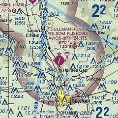
|
| Airport distance calculator |
|---|
|
|
| Sunrise and sunset |
|---|
|
Times for 04-Mar-2025
| | Local
(UTC-6) | | Zulu
(UTC) |
|---|
| Morning civil twilight | | 05:48 | | 11:48 |
| Sunrise | | 06:14 | | 12:14 |
| Sunset | | 17:45 | | 23:45 |
| Evening civil twilight | | 18:10 | | 00:10 |
|
| Current date and time |
|---|
| Zulu (UTC) | 04-Mar-2025 19:21:35 |
|---|
| Local (UTC-6) | 04-Mar-2025 13:21:35 |
|---|
|
| METAR |
|---|
| KCMD | 041855Z AUTO 13014G24KT 090V180 10SM CLR 21/09 A2979 RMK AO2
|
|
| TAF |
|---|
KHSV
23nm N | 041720Z 0418/0518 16023G32KT P6SM SCT035 BKN080 BKN250 WS020/18045KT FM042100 15026G35KT P6SM VCSH BKN040 OVC080 WS020/18045KT FM050100 15028G40KT P6SM VCSH BKN040 OVC060 TEMPO 0502/0504 24035G45KT 2SM +TSRA BR BKN020 OVC035CB FM050400 19013G22KT P6SM SCT040 OVC250 FM051100 22019G24KT P6SM BKN030
|
KHUA
26nm N | 041200Z 0412/0518 13009KT 9999 FEW075 510043 QNH2998INS BECMG 0415/0416 14015G20KT 9999 FEW075 510043 QNH2996INS BECMG 0417/0418 15025G35KT 9999 SCT035 520034 QNH2953INS BECMG 0500/0501 15018KT 9000 -SHRA BKN020 520058 QNH2945INS TEMPO 0501/0506 VRB25G35KT 3200 TSRA OVC015CB BECMG 0507/0508 21015KT 9999 NSW FEW029 520052 QNH2943INS BECMG 0515/0516 23020G25KT 9999 FEW014 QNH2954INS BECMG 0516/0517 24025G35KT 9999 BKN014 QNH2955INS TX19/0420Z TN04/0412Z
|
|
| NOTAMs |
|---|
NOTAMs are issued by the DoD/FAA and will open in a separate window not controlled by AirNav.
|
|


