FAA INFORMATION EFFECTIVE 09 JULY 2026
Location
| FAA Identifier: | 5R4 |
| Lat/Long: | 30-25-39.6000N 087-42-03.5000W
30-25.660000N 087-42.058333W
30.4276667,-87.7009722
(estimated) |
| Elevation: | 74.3 ft. / 22.6 m (surveyed) |
| Variation: | 02W (2010) |
| From city: | 3 miles NW of FOLEY, AL |
| Time zone: | UTC -5 (UTC -6 during Standard Time) |
| Zip code: | 36535 |
Airport Operations
| Airport use: | Open to the public |
| Activation date: | 02/1967 |
| Control tower: | no |
| ARTCC: | JACKSONVILLE CENTER |
| FSS: | ANNISTON FLIGHT SERVICE STATION |
| NOTAMs facility: | ANB (NOTAM-D service available) |
| Attendance: | 0800-1700 |
| Wind indicator: | lighted |
| Segmented circle: | yes |
| Lights: | ACTVT PAPI RWY 18 & 36; MIRL RWY 18/36 - CTAF. MIRL RWY 18/36 PRESET LOW INTST; INCR INTST - CTAF. |
| Beacon: | white-green (lighted land airport)
Operates sunset to sunrise. |
Airport Communications
| CTAF/UNICOM: | 123.05 |
| PENSACOLA APPROACH: | 118.6 ;251-339 |
| PENSACOLA DEPARTURE: | 118.6 ;251-339 |
| CLASS C: | 118.6 ;251-339 |
| WX AWOS-3PT at JKA (8 nm S): | PHONE 251-923-5615 |
| WX AWOS-3PT at CQF (9 nm W): | 118.425 (251-928-3242) |
Nearby radio navigation aids
| VOR radial/distance | | VOR name | | Freq | | Var |
|---|
| NUNr261/(19.1) | | SAUFLEY VOR | | 112.25 | | 01E |
| BFMr117/21.4 | | BROOKLEY VORTAC | | 116.35 | | 04E |
| SJIr113/38.4 | | SEMMES VORTAC | | 115.30 | | 05E |
| NDB name | | Hdg/Dist | | Freq | | Var | | ID |
|---|
| WISLE | | 124/37.0 | | 248 | | 01W | | MOB | -- --- -... |
Airport Services
| Fuel available: | 100LL
100LL:FULL SVC AVGAS DURG NML HRS ONLY. |
| Parking: | tiedowns |
| Airframe service: | MAJOR |
| Powerplant service: | MAJOR |
| Bottled oxygen: | NONE |
| Bulk oxygen: | NONE |
Runway Information
Runway 18/36
| Dimensions: | 3700 x 74 ft. / 1128 x 23 m |
| Surface: | asphalt, in good condition |
| Weight bearing capacity: | |
| Runway edge lights: | medium intensity |
| Runway edge markings: | HOLD SHORT MARKINGS ARE FAIR CONDITION |
| RUNWAY 18 | | RUNWAY 36 |
| Latitude: | 30-25.965772N | | 30-25.355465N |
| Longitude: | 087-42.057533W | | 087-42.058022W |
| Elevation: | 62.7 ft. | | 74.3 ft. |
| Traffic pattern: | right | | left |
| Runway heading: | 182 magnetic, 180 true | | 002 magnetic, 360 true |
| Displaced threshold: | no | | 187 ft. |
| Markings: | nonprecision, in good condition | | nonprecision, in good condition |
| Visual slope indicator: | 2-light PAPI on left (3.00 degrees glide path) | | 2-light PAPI on left (3.00 degrees glide path)
PAPI UNUSBL BYD 6 DEG LEFT OF CNTRLN. |
| Touchdown point: | yes, no lights | | yes, no lights |
| Obstructions: | 60 ft. tree, 1308 ft. from runway, 205 ft. left of centerline, 18:1 slope to clear | | 91 ft. road, 1797 ft. from runway, 200 ft. right of centerline, 17:1 slope to clear |
Airport Ownership and Management from official FAA records
| Ownership: | Publicly-owned |
| Owner: | CITY OF FOLEY
P.O. BOX 1750
FOLEY, AL 36536
Phone 251-943-1545 |
| Manager: | RACHEL KEITH
510 AIRPORT DR
FOLEY, AL 36535
Phone 251-943-1545 |
Additional Remarks
| - | EXTSV STUDENT TRNG. |
| - | CIRCLING APCH NA EAST OF RWY. VOLUNTARY NOISE ABATEMENT PROC IN EFCT MON-SUN NGT TIME. VOLUNTARY RSTRS ON TOUCH AND GO, STOP AND GO, OR HEL OPS MON-SUN NGT TIME. RWY 18 NGT TIME PREFERENTIAL USE RWY FOR ALL ACFT DEP WHEN WINDS PERMIT. |
| - | LTD PRKG ON NORTH RAMP. TSNT ACFT URGED TO BRING TIE-DOWN ROPES FOR SOUTH RAMP PKNG. NO RAMP FEES EXCP ACFT OVER NGT PRKG. |
| - | FOR CD CTC PENSACOLA APCH AT 850-266-6884 OR 850-266-6885. |
Instrument Procedures
NOTE: All procedures below are presented as PDF files. If you need a reader for these files, you should download the free Adobe Reader.NOT FOR NAVIGATION. Please procure official charts for flight.
FAA instrument procedures published for use from 09 July 2026 at 0901Z to 06 August 2026 at 0900Z.
IAPs - Instrument Approach Procedures |
|---|
| RNAV (GPS) RWY 18 | |
download (244KB) |
| RNAV (GPS) RWY 36 | |
download (215KB) |
| NOTE: Special Take-Off Minimums/Departure Procedures apply | |
download (518KB) |
Other nearby airports with instrument procedures:
KJKA - Gulf Shores International Airport/Jack Edwards Field (8 nm S)
KCQF - H L Sonny Callahan Airport (9 nm W)
KNPA - Pensacola Naval Air Station (Forrest Sherman Field) Airport (20 nm E)
KBFM - Mobile International Airport (22 nm NW)
KPNS - Pensacola International Airport (27 nm E)
|
|

Road maps at:
MapQuest
Bing
Google
| Aerial photo |
|---|
WARNING: Photo may not be current or correct
 Photo taken 05-Sep-2010
looking east.
Photo taken 05-Sep-2010
looking east.
Do you have a better or more recent aerial photo of Holk Field at Foley Municipal Airport that you would like to share? If so, please send us your photo.
|
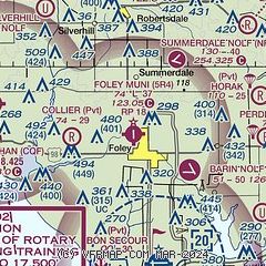
| Sectional chart |
|---|
|
| Airport distance calculator |
|---|
|
|
| Sunrise and sunset |
|---|
|
Times for 25-Jul-2026
| | Local
(UTC-5) | | Zulu
(UTC) |
|---|
| Morning civil twilight | | 05:39 | | 10:39 |
| Sunrise | | 06:06 | | 11:06 |
| Sunset | | 19:49 | | 00:49 |
| Evening civil twilight | | 20:15 | | 01:15 |
|
| Current date and time |
|---|
| Zulu (UTC) | 25-Jul-2026 13:49:56 |
|---|
| Local (UTC-5) | 25-Jul-2026 08:49:56 |
|---|
|
| METAR |
|---|
KNBJ
4nm SE | 251254Z AUTO 32005KT 10SM CLR 27/25 A3011 RMK AO2 SLP194 T02720250 $
|
KJKA
8nm S | 251157Z 23003KT 10SM CLR 26/26 A3010
|
KCQF
9nm W | 251335Z AUTO 30006KT 10SM CLR 28/24 A3013 RMK AO2
|
|
| TAF |
|---|
KJKA
8nm S | 251129Z 2512/2612 33003KT P6SM SKC FM251800 26007KT P6SM FEW045 FM252100 22010KT P6SM FEW045 SCT250 FM260200 24005KT P6SM SCT060 SCT250
|
|
| NOTAMs |
|---|
NOTAMs are issued by the DoD/FAA and will open in a separate window not controlled by AirNav.
|
|

