FAA INFORMATION EFFECTIVE 16 APRIL 2026
Location
| FAA Identifier: | NPA |
| Lat/Long: | 30-21-11.7819N 087-19-04.6961W
30-21.196365N 087-19.078268W
30.3532728,-87.3179711
(estimated) |
| Elevation: | 28.2 ft. / 8.6 m (surveyed) |
| Variation: | 03W (2025) |
| From city: | 6 miles SW of PENSACOLA, FL |
| Time zone: | UTC -5 (UTC -6 during Standard Time) |
| Zip code: | 32508 |
Airport Operations
| Airport use: | Private use. Permission required prior to landing |
| Control tower: | yes |
| ARTCC: | JACKSONVILLE CENTER |
| FSS: | GAINESVILLE FLIGHT SERVICE STATION
FSS-GAINESVILLE GNV- NOTAM PNS |
| NOTAMs facility: | NPA (NOTAM-D service available) |
| Attendance: | MAR-NOV MON-FRI 1200-0300Z, ALL SAT CLSD, ALL SUN 2100-0230Z++, NOV-MAR 1300-0300Z
HOL BY NOTAM. SEE FLIP AP/1 SUPPLEMENTARY ARPT RMK. |
| Segmented circle: | no |
| Lights: | AVBL ONLY DURING HRS OF OPERATION. |
| Beacon: | white-white-green (lighted military airport)
Operates sunset to sunrise. |
Airport Communications
| ATIS: | 124.35 266.8 |
| SHERMAN GROUND: | 121.7 336.4 [1300-0300Z++ MON-FRI; CLSD SAT; 2100-0230Z++ SUN, HOL BY NOTAM.] |
| SHERMAN TOWER: | 120.7 340.2 [1300-0300Z++ MON-FRI; CLSD SAT; 2100-0230Z++ SUN, HOL BY NOTAM.] |
| PENSACOLA APPROACH: | 120.65 120.65 |
| PENSACOLA DEPARTURE: | 120.65 120.65 |
| CLEARANCE DELIVERY: | 134.1 268.7 |
| BASE OPS: | 312.1 |
| CLASS C: | 120.65 |
| PMSV METRO: | 359.6 |
| WX ASOS at PNS (10 nm NE): | 121.25 (850-436-4799) |
| WX AWOS-3PT at JKA (19 nm W): | PHONE 251-923-5615 |
- SFA.
- DEP ACFT CTC CLNC DEL PRIOR TAXI.
Nearby radio navigation aids
| VOR radial/distance | | VOR name | | Freq | | Var |
|---|
| NUNr172/(7.2) | | SAUFLEY VOR | | 112.25 | | 01E |
Airport Services
| Airframe service: | NONE |
| Powerplant service: | NONE |
| Bottled oxygen: | NONE |
| Bulk oxygen: | NONE |
Runway Information
Runway 7L/25R
| Dimensions: | 8001 x 200 ft. / 2439 x 61 m |
| Surface: | asphalt |
| Weight bearing capacity: | |
| Runway edge lights: | high intensity |
| RUNWAY 7L | | RUNWAY 25R |
| Latitude: | 30-21.046435N | | 30-21.533853N |
| Longitude: | 087-19.746672W | | 087-18.332095W |
| Elevation: | 23.4 ft. | | 16.1 ft. |
| Traffic pattern: | left | | left |
| Visual slope indicator: | 4-light PAPI on left (3.00 degrees glide path) | | 4-light PAPI on left (3.00 degrees glide path) |
| Approach lights: | ALSF1: standard 2,400 foot high intensity approach lighting system with centerline sequenced flashers (category I) | | |
| Runway end identifier lights: | | | yes |
| Touchdown point: | yes, no lights | | yes, no lights |
| Instrument approach: | ILS/DME | | |
Runway 7R/25L
| Dimensions: | 8000 x 200 ft. / 2438 x 61 m |
| Surface: | asphalt |
| Weight bearing capacity: | |
| Runway edge lights: | high intensity |
| RUNWAY 7R | | RUNWAY 25L |
| Latitude: | 30-20.939255N | | 30-21.426528N |
| Longitude: | 087-19.697417W | | 087-18.282992W |
| Elevation: | 24.1 ft. | | 15.2 ft. |
| Traffic pattern: | left | | left |
| Visual slope indicator: | 4-light PAPI on left (3.00 degrees glide path) | | 4-light PAPI on left (3.00 degrees glide path) |
| Touchdown point: | yes, no lights | | yes, no lights |
Runway 1/19
| Dimensions: | 7136 x 200 ft. / 2175 x 61 m |
| Surface: | asphalt |
| Weight bearing capacity: | |
| Runway edge lights: | high intensity |
| RUNWAY 1 | | RUNWAY 19 |
| Latitude: | 30-20.521157N | | 30-21.691475N |
| Longitude: | 087-19.294260W | | 087-19.146952W |
| Elevation: | 27.8 ft. | | 16.1 ft. |
| Traffic pattern: | left | | left |
| Visual slope indicator: | 4-light PAPI on left (3.00 degrees glide path) | | 4-light PAPI on left (3.00 degrees glide path) |
| Touchdown point: | yes, no lights | | yes, no lights |
Airport Ownership and Management from official FAA records
| Ownership: | U.S. Navy |
| Owner: | US NAVY
OCEANOGRAPHIC OFC-CODE 3142
WASHINGTON, DC 20373 |
| Manager: | COMMANDING OFFICER
NAVAL AIR STATION
PENSACOLA, FL 32508
Phone 850-452-2735 |
Additional Remarks
| E60-01 | HOOK E28(B)(1554') |
| E60-25R | HOOK E28(B) (1300') |
| E60-25L | HOOK E28(B) (1450') |
| E60-07L | HOOK E28(B) (1200') |
| E60-19 | HOOK E28(B) (1100') |
| E60-07R | HOOK E28(B) (1300') |
| - | TFC PAT: LDG/TAXI LGT RQR ALL LDG WHEN WX COND PERMIT. WHEELS WATCH NOT ON STN. SEE MANDATORY IFR ARR PRO-FLIP AP/1 SUPPLEMENTARY ARPT RMK. REDUCED RWY SEPARATION STD IN EFF CNATRA ACFT ONLY. MULTIPLE APCH SEVERELY LTD DUR SINGLE RWY OPR. |
| - | NS ABTMT: REQ ALL ACFT REMAIN AT OR ABV 500' AND 0.5 NM OFF-SHORE FR NAVARRE BEACH TO W OF JOHNSON BEACH DUE TO NESTING OF PROTECTED SPECIES APR-OCT. |
| - | CSTMS/AG/IMG: CSTMS, AG AVBL IF PRIOR ARNG MADE WITH MIN 48 HR ADVANCE NTC. |
| - | CAUTION: EXPECT SIMULTANEOUS OPR DUR DUAL RY OPERATIONS. PONDING OCCURS AFTER MODERATE TO HVY RAIN AT ALL RY INT AND HOLD SHORT AREAS. RY 7L-R/25L-R GROOVED. RY 1/19 NOT GROOVED. |
| - | MISC- SECTOR CONTROL PENSACOLA, FL KNPA (CALL SIGN SEABREEZE) C850-452-2041, SKEDS HOURS 1200-2100Z++ MON-FRI, MAR-NOV; 1300-2200Z MON-FRI; NOV-MAR. (R) CTL SVC AND SKED PROVIDED IN W155 TO ALL MIL AND DESIGNATED CIV AIR OPR. ALL ACFT OPR IN W155 SHALL BE SKED, CHECK IN/OUT ON PRIM FREQ AND REMAIN IN CONTINUOUS RDO COM WITH SEABREEZE OR WITH THE MIL RADAR UNIT/FAC SPECIFICALLY AUTH BY SEABREEZE TO PROVIDE CTL/CONTAINMENT SVC. ACFT OPR BLW 3500- MAY NOT RECEIVE RADAR SVC DUE TO LIMITED RADAR/RADIO COVERAGE. FOR DETAILED WARNING OP AREA SKED/USE PRO, CTC SECTOR CONTROL PENSACOLA. SEABREEZE - (PRIM)-(E) (127.45 351.625) 348.0 3102.4 6835.4 H-5D, L18E, F. FLT PLANS FOR NAS PENSACOLA CAN BE SUBMITTED TO BASE OPS VIA FAX AT C850-452-8105 OR E-MAIL: CNIC_SE_PNSC_NPA_BASE_OPS@US.NAVY.MIL. TO CONFIRM RECEIPT OF FLT PLANS CTC FLT PLANNING DISPATCHER C850-452-2265/2041. KNPA ASOS DIAL-IN C850-452-3040. |
| - | ACFT EXP TO CONDUCT OPR FR SHERMAN FLD CTC FLEET LIAISON OFFICE DSN 459-4333, C850-452-4333 FOR SKED. |
| - | CIV ACFT LDG PMT CTC DEPUTY AIR OPS OFFICER DSN:459-2547 C:850-452-2547. |
| - | RSTD - B-52 OPS PROH. PPR REQ FOR ALL TRANSIENT AIRCRAFT. PPR VALID PLUS OR MINUS 30 MIN. OF APPRVD TIME NOT TO EXCEED BEYOND NORMAL AIRFLD CLOSURE TIME. FAILURE TO ARRIVE WITHIN THE ASSIGNED WINDOW MAY RESULT IN DENIAL OF LANDING CLEARANCE., CTC TRAN LINE DSN 850-459-2672, C850-452-2672. |
| - | A-GEAR: 15 MIN NTC FOR SHORT FIELD ARRESTMENT. |
| - | JASU - 2(NC-10) 2(MSU-200) |
| - | FUEL: JET A++ |
| - | FLUID - SP LHOX LOX OXRB ACFT NITROGEN AND OX SVCG AVBL MAR-NOV 1200-0300Z, MON-FRI, NOV-MAR 1300-0300Z, CLSD SAT-SUN, OPEN BY NOTAM, AND HOL BY NOTAM. |
| - | OIL: O-128-148-156 |
| - | TRAN SVC AVBL, CTC FOR HOURS, CLSD SAT-SUN, HOL BY NOTAM ; OT NO TRAN ACFT AUTH. |
Instrument Procedures
NOTE: All procedures below are presented as PDF files. If you need a reader for these files, you should download the free Adobe Reader.NOT FOR NAVIGATION. Please procure official charts for flight.
FAA instrument procedures published for use from 16 April 2026 at 0901Z to 14 May 2026 at 0900Z.
Other nearby airports with instrument procedures:
KPNS - Pensacola International Airport (10 nm NE)
KJKA - Gulf Shores International Airport/Jack Edwards Field (19 nm W)
5R4 - Holk Field at Foley Municipal Airport (20 nm W)
2R4 - Peter Prince Field Airport (24 nm NE)
KNDZ - Whiting Field Naval Air Station South (26 nm NE)
|
|

Road maps at:
MapQuest
Bing
Google
| Aerial photo |
|---|
WARNING: Photo may not be current or correct

Do you have a better or more recent aerial photo of Pensacola Naval Air Station (Forrest Sherman Field) Airport that you would like to share? If so, please send us your photo.
|
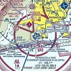
| Sectional chart |
|---|
|
 Download PDF
of official airport diagram from the FAA
| Airport distance calculator |
|---|
|
|
| Sunrise and sunset |
|---|
|
Times for 27-Apr-2026
| | Local
(UTC-5) | | Zulu
(UTC) |
|---|
| Morning civil twilight | | 05:45 | | 10:45 |
| Sunrise | | 06:11 | | 11:11 |
| Sunset | | 19:23 | | 00:23 |
| Evening civil twilight | | 19:49 | | 00:49 |
|
| Current date and time |
|---|
| Zulu (UTC) | 28-Apr-2026 03:55:03 |
|---|
| Local (UTC-5) | 27-Apr-2026 22:55:03 |
|---|
|
| METAR |
|---|
| KNPA | 280256Z 14009KT 10SM FEW010 23/21 A3005 RMK AO2 SLP178 T02280211 50005 $
|
KPNS
10nm NE | 280323Z 15009KT 10SM FEW008 22/21 A3006 RMK AO2 T02220206
|
KJKA
19nm W | 280335Z AUTO 14007G12KT 9SM CLR 23/22 A3004 RMK AO2
|
|
| TAF |
|---|
| KNPA | 2723/2823 16007KT 9999 FEW012 FEW250 QNH3001INS FM280600 VRB03KT 9999 SCT012 SCT250 QNH2999INS TEMPO 2808/2812 4800 BR BKN012 BKN250 FM281200 15006KT 9999 SCT015 BKN250 QNH3004INS TEMPO 2812/2816 BKN015 FM281800 17012KT 9999 FEW020 SCT050 SCT170 BKN250 QNH2998INS AUTOMATED SENSOR METWATCH 2803 TIL 2811 TX26/2819Z TN20/2811Z FN20053
|
KPNS
10nm NE | 272052Z 2721/2818 16013KT P6SM SKC FM280000 17007KT P6SM FEW250 FM280500 16004KT P6SM FEW080
|
KJKA
19nm W | 271720Z 2718/2818 12009G14KT P6SM SKC FM272200 15008KT P6SM FEW030 FM280100 16005KT P6SM FEW050
|
|
| NOTAMs |
|---|
NOTAMs are issued by the DoD/FAA and will open in a separate window not controlled by AirNav.
|
|


