FAA INFORMATION EFFECTIVE 27 NOVEMBER 2025
Location
| FAA Identifier: | 63C |
| Lat/Long: | 43-57-38.1171N 089-47-19.1200W
43-57.635285N 089-47.318667W
43.9605881,-89.7886444
(estimated) |
| Elevation: | 979.2 ft. / 298.5 m (surveyed) |
| Variation: | 01W (1995) |
| From city: | 1 mile E of FRIENDSHIP (ADAMS), WI |
| Time zone: | UTC -6 (UTC -5 during Daylight Saving Time) |
| Zip code: | 53934 |
Airport Operations
| Airport use: | Open to the public |
| Control tower: | no |
| ARTCC: | CHICAGO CENTER |
| FSS: | GREEN BAY FLIGHT SERVICE STATION |
| NOTAMs facility: | GRB (NOTAM-D service available) |
| Attendance: | UNATNDD |
| Wind indicator: | lighted |
| Segmented circle: | yes |
| Lights: | MIRL RWY 15/33 PRESET TO LOW SS-SR; TO INCR INTST & ACTVT REILS RWY 15 & 33 - CTAF. |
| Beacon: | white-green (lighted land airport)
Operates sunset to sunrise. |
Airport Communications
| CTAF: | 122.9 |
| VOLK APPROACH: | 135.25 |
| VOLK DEPARTURE: | 135.25 |
| WX AWOS-3 at 82C (17 nm SW): | 123.925 (608-562-6153) |
- APCH/DEP SVC PRVDD BY CHICAGO ARTCC (ZAU) ON FREQS 125.05/269.375 (CAMP DOUGLAS RCAG) WHEN VOLK APCH CTL CLSD.
Nearby radio navigation aids
| VOR radial/distance | | VOR name | | Freq | | Var |
|---|
| DLLr354/24.6 | | DELLS VORTAC | | 117.00 | | 03E |
| NDB name | | Hdg/Dist | | Freq | | Var | | ID |
|---|
| MCCOY | | 088/36.9 | | 412 | | 00E | | CMY | -.-. -- -.-- |
Airport Services
| Fuel available: | 100LL
100LL:FUEL AVBL H24 VIA CREDIT CARD. |
| Parking: | tiedowns |
| Airframe service: | NONE |
| Powerplant service: | NONE |
| Bottled oxygen: | NONE |
| Bulk oxygen: | NONE |
Runway Information
Runway 15/33
| Dimensions: | 3398 x 60 ft. / 1036 x 18 m |
| Surface: | asphalt, in good condition |
| Weight bearing capacity: | |
| Runway edge lights: | medium intensity |
| RUNWAY 15 | | RUNWAY 33 |
| Latitude: | 43-57.897525N | | 43-57.395970N |
| Longitude: | 089-47.552560W | | 089-47.209955W |
| Elevation: | 968.4 ft. | | 979.0 ft. |
| Traffic pattern: | left | | left |
| Runway heading: | 154 magnetic, 153 true | | 334 magnetic, 333 true |
| Markings: | nonprecision, in fair condition | | nonprecision, in fair condition |
| Visual slope indicator: | 2-light PAPI on left (3.00 degrees glide path)
OPER CONSLY. | | 2-light PAPI on left (3.00 degrees glide path)
OPER CONSLY. |
| Runway end identifier lights: | yes | | yes |
| Touchdown point: | yes, no lights | | yes, no lights |
| Obstructions: | 34 ft. trees, 700 ft. from runway, 285 ft. left of centerline, 14:1 slope to clear | | 59 ft. trees, 630 ft. from runway, 300 ft. right of centerline, 7:1 slope to clear |
Runway 8/26
| Dimensions: | 2780 x 100 ft. / 847 x 30 m |
| Surface: | turf, in fair condition |
| Runway edge markings: | MKD WITH WHITE CONES. |
| Operational restrictions: | CLSD DEC 1 - APR 1. |
| RUNWAY 8 | | RUNWAY 26 |
| Latitude: | 43-57.583217N | | 43-57.659335N |
| Longitude: | 089-47.554413W | | 089-46.929913W |
| Elevation: | 973.5 ft. | | 978.1 ft. |
| Traffic pattern: | left | | left |
| Runway heading: | 081 magnetic, 080 true | | 261 magnetic, 260 true |
| Touchdown point: | yes, no lights | | yes, no lights |
Airport Ownership and Management from official FAA records
| Ownership: | Publicly-owned |
| Owner: | ADAMS COUNTY
401 ADAMS ST, STE 10
FRIENDSHIP, WI 53934
Phone 608-339-4200 |
| Manager: | KYLE PATTERSON
401 ADAMS ST, STE 10
FRIENDSHIP, WI 53934
Phone 608-339-4201 |
Additional Remarks
| - | ULTRALIGHT ACT ON & INVOF ARPT. |
| - | ACFT DEP RWY 15 REQD TO TURN TO HDG OF 180 DEG AFT TAKEOFF. |
| - | FOR CD CTC CHICAGO ARTCC AT 630-906-8921. |
| - | CROP DUSTING ACT ON & INVOF ARPT. |
Instrument Procedures
NOTE: All procedures below are presented as PDF files. If you need a reader for these files, you should download the free Adobe Reader.NOT FOR NAVIGATION. Please procure official charts for flight.
FAA instrument procedures published for use from 27 November 2025 at 0901Z to 25 December 2025 at 0900Z.
IAPs - Instrument Approach Procedures |
|---|
| RNAV (GPS) RWY 33 | |
download (213KB) |
| NOTE: Special Take-Off Minimums/Departure Procedures apply | |
download (484KB) |
Other nearby airports with instrument procedures:
KDAF - Necedah Airport (14 nm W)
82C - Mauston/New Lisbon Union Airport (17 nm SW)
KVOK - Volk Field Airport (20 nm W)
Y50 - Wautoma Municipal Airport (21 nm E)
KISW - Alexander Field South Wood County Airport (24 nm N)
|
|

Road maps at:
MapQuest
Bing
Google
| Aerial photo |
|---|
WARNING: Photo may not be current or correct
 Photo by Mathieu Labs
Photo taken 07-May-2006
Photo by Mathieu Labs
Photo taken 07-May-2006
Do you have a better or more recent aerial photo of Adams County Airport-Legion Field that you would like to share? If so, please send us your photo.
|
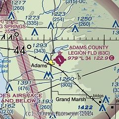
| Sectional chart |
|---|
|
| Airport distance calculator |
|---|
|
|
| Sunrise and sunset |
|---|
|
Times for 07-Dec-2025
| | Local
(UTC-6) | | Zulu
(UTC) |
|---|
| Morning civil twilight | | 06:48 | | 12:48 |
| Sunrise | | 07:21 | | 13:21 |
| Sunset | | 16:20 | | 22:20 |
| Evening civil twilight | | 16:53 | | 22:53 |
|
| Current date and time |
|---|
| Zulu (UTC) | 07-Dec-2025 18:39:48 |
|---|
| Local (UTC-6) | 07-Dec-2025 12:39:48 |
|---|
|
| METAR |
|---|
K82C
17nm SW | 071815Z AUTO 30009KT 10SM CLR M11/M17 A3027 RMK AO2 T11071172
|
KVOK
21nm W | 071755Z AUTO 31007KT 10SM CLR M10/M18 A3026 RMK AO2 SLP268 T11051185 11105 21141 51015 $
|
KY50
21nm E | 071756Z AUTO 32009KT 10SM CLR M09/M16 A3027 RMK AO2 SLP264 6//// T10891156 11083 21139 51015 FZRANO $
|
KISW
24nm N | 071754Z AUTO 33010KT 10SM CLR M13/M19 A3028 RMK AO2 SLP276 T11281189 11128 21161 50015
|
KDLL
26nm S | 071815Z AUTO 33008KT 10SM CLR M08/M17 A3026 RMK AO2 T10831167
|
KC35
27nm S | 071815Z AUTO 34006KT 10SM CLR M10/M18 A3027 RMK AO2 T10961180 PWINO
|
|
| TAF |
|---|
KVOK
21nm W | 071700Z 0717/0823 19009KT 9999 SKC 520006 QNH3024INS BECMG 0805/0806 VRB03KT 9999 BKN010 620107 QNH3014INS BECMG 0815/0816 19012KT 9000 -SN BKN010 620107 520006 QNH3014INS BECMG 0821/0822 18015G20KT 9000 -SN SCT008 BKN015 620157 520006 QNH3000INS TXM09/0817Z TNM23/0803Z
|
|
| NOTAMs |
|---|
NOTAMs are issued by the DoD/FAA and will open in a separate window not controlled by AirNav.
|
|

