FAA INFORMATION EFFECTIVE 19 FEBRUARY 2026
Location
| FAA Identifier: | 65G |
| Lat/Long: | 42-43-05.0096N 084-03-38.4490W
42-43.083493N 084-03.640817W
42.7180582,-84.0606803
(estimated) |
| Elevation: | 906 ft. / 276 m (estimated) |
| Variation: | 05W (1985) |
| From city: | 3 miles N of FOWLERVILLE, MI |
| Time zone: | UTC -5 (UTC -4 during Daylight Saving Time) |
| Zip code: | 48836 |
Airport Operations
| Airport use: | Open to the public |
| Activation date: | 02/1974 |
| Control tower: | no |
| ARTCC: | CLEVELAND CENTER |
| FSS: | LANSING FLIGHT SERVICE STATION |
| NOTAMs facility: | LAN (NOTAM-D service available) |
| Attendance: | JUN-OCT IREG |
| Wind indicator: | yes |
| Segmented circle: | no |
| Lights: | SS-SR |
Airport Communications
| CTAF/UNICOM: | 122.8 |
| WX AWOS-3P at OZW (6 nm SE): | 118.875 (517-546-4450) |
| WX AWOS-3 at RNP (17 nm N): | 118.025 (989-729-2967) |
| WX AWOS-3P at TEW (18 nm SW): | 119.425 (517-676-5607) |
Nearby radio navigation aids
| VOR radial/distance | | VOR name | | Freq | | Var |
|---|
| FNTr229/20.3 | | FLINT VORTAC | | 116.90 | | 06W |
| SVMr315/27.8 | | SALEM VORTAC | | 114.30 | | 03W |
Airport Services
| Parking: | tiedowns |
| Airframe service: | MAJOR |
| Powerplant service: | MAJOR |
Runway Information
Runway 9/27
| Dimensions: | 3050 x 110 ft. / 930 x 34 m |
| Surface: | turf, in good condition |
| Runway edge lights: | low intensity |
| Runway edge markings: | RWY & DTHR MKD WITH 3 FT YELLOW CONES. |
| RUNWAY 9 | | RUNWAY 27 |
| Latitude: | 42-43.121000N | | 42-43.118000N |
| Longitude: | 084-04.073000W | | 084-03.392000W |
| Elevation: | 906.0 ft. | | 901.0 ft. |
| Traffic pattern: | left | | left |
| Runway heading: | 095 magnetic, 090 true | | 275 magnetic, 270 true |
| Displaced threshold: | 200 ft. | | 300 ft. |
| Obstructions: | 20 ft. gnd, 345 ft. from runway, 125 ft. left and right of centerline, 17:1 slope to clear
APCH RATIO 20:1 TO DTHR. | | 15 ft. road, 30 ft. from runway, 125 ft. left and right of centerline, 2:1 slope to clear
APCH RATIO 20:1 TO DTHR. |
Runway 18/36
| Dimensions: | 2000 x 113 ft. / 610 x 34 m |
| Surface: | turf, in good condition |
| Runway edge lights: | low intensity |
| Runway edge markings: | RWY & DTHR MKD WITH 3 FT YELLOW CONES. |
| RUNWAY 18 | | RUNWAY 36 |
| Latitude: | 42-43.193000N | | 42-42.864167N |
| Longitude: | 084-03.508000W | | 084-03.494000W |
| Elevation: | 898.0 ft. | | 903.0 ft. |
| Traffic pattern: | left | | left |
| Displaced threshold: | 550 ft. | | 275 ft. |
| Obstructions: | 4 ft. fence, marked and lighted, 75 ft. left of centerline, 1:1 slope to clear
APCH RATIO 20:1 TO DTHR OVR +55 FT MKD & LGTD PLINE, 550 FT DIST, 180 FT L/R. | | 15 ft. road, 25 ft. from runway, 125 ft. left and right of centerline, 1:1 slope to clear
APCH RATIO 20:1 TO DTHR. |
Airport Ownership and Management from official FAA records
| Ownership: | Privately-owned |
| Owner: | LUNDY LLC
102 CHICAGO AVE
CHARLEVOIX, MI 49720-1549
Phone 231-622-2052 |
| Manager: | PAULO ROBERTO PINTO DA SILVA
7080 W SHERWOOD RD
FOWLERVILLE, MI 48836-9371
Phone 517-245-4387
ALTN CTC E66 AMGR. |
Additional Remarks
| - | ARPT IS COLOCATED WITH E66 HLP, BE ALERT FOR ROTARY WING ACFT. |
| - | EXTSV ACFT TRG, TWO-WAY RDO COMS RQRD. |
| - | FOR CD CTC GREAT LAKES APCH AT 269-459-3345, WHEN APCH CLSD CTC CLEVELAND ARTCC AT 440-774-0224/0490. |
| - | FICONS UNMON NOV-MAY. NO SNOW REMOVAL. |
| - | DEER & LRG BIRDS ON & INVOF ARPT. |
Instrument Procedures
There are no published instrument procedures at 65G.
Some nearby airports with instrument procedures:
KOZW - Livingston County/Spencer J Hardy Airport (6 nm SE)
9G2 - Price's Airport (14 nm NE)
KRNP - Owosso Community Airport (17 nm N)
KTEW - Mason Jewett Field Airport (18 nm SW)
KFNT - Bishop International Airport (20 nm NE)
|
|

Road maps at:
MapQuest
Bing
Google
| Aerial photo |
|---|
WARNING: Photo may not be current or correct

Do you have a better or more recent aerial photo of Maple Grove Airport that you would like to share? If so, please send us your photo.
|
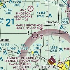
| Sectional chart |
|---|
|
| Airport distance calculator |
|---|
|
|
| Sunrise and sunset |
|---|
|
Times for 19-Feb-2026
| | Local
(UTC-5) | | Zulu
(UTC) |
|---|
| Morning civil twilight | | 07:00 | | 12:00 |
| Sunrise | | 07:29 | | 12:29 |
| Sunset | | 18:12 | | 23:12 |
| Evening civil twilight | | 18:40 | | 23:40 |
|
| Current date and time |
|---|
| Zulu (UTC) | 19-Feb-2026 12:23:32 |
|---|
| Local (UTC-5) | 19-Feb-2026 07:23:32 |
|---|
|
| METAR |
|---|
KOZW
7nm SE | 191155Z AUTO 14009KT 1SM BR BKN001 02/01 A2974 RMK AO2 10034 20016 70023
|
KRNP
17nm N | 191155Z AUTO 14005KT 3SM BR OVC003 01/01 A2975 RMK AO2 T00130007 10013 20005
|
KTEW
18nm SW | 191155Z AUTO 15008KT 7SM OVC005 02/02 A2974 RMK AO2 T00150015 10057 20011
|
|
| TAF |
|---|
KFNT
20nm NE | 191137Z 1912/2012 14007KT 3SM BR OVC004 FM191300 14005KT 3/4SM BR VV003 TEMPO 1915/1918 2SM SHRA BR OVC006 FM191800 13007KT 2SM -SHRA BR OVC008 FM192100 13010KT 4SM BR OVC015 FM200100 11007KT 2SM -SHRA BR OVC008 FM200700 11005KT 1SM -RA BR OVC004
|
KLAN
23nm W | 191153Z 1912/2012 14008KT P6SM BKN100 PROB30 1914/1918 5SM -SHRA BR BKN050 FM191800 13008KT P6SM SCT050 PROB30 1918/1922 5SM -SHRA BR BKN025 FM192200 11008KT P6SM BKN015 FM200300 10009KT 2SM SHRA BR OVC005 FM200900 15010KT 4SM BR BKN009
|
|
| NOTAMs |
|---|
NOTAMs are issued by the DoD/FAA and will open in a separate window not controlled by AirNav.
|
|

