FAA INFORMATION EFFECTIVE 14 MAY 2026
Location
| FAA Identifier: | 6CM |
| Lat/Long: | 40-17-43.6200N 082-43-47.9000W
40-17.727000N 082-43.798333W
40.2954500,-82.7299722
(estimated) |
| Elevation: | 1180 ft. / 360 m (estimated) |
| Variation: | 05W (1985) |
| From city: | 2 miles SW of CENTERBURG, OH |
| Time zone: | UTC -4 (UTC -5 during Standard Time) |
| Zip code: | 43011 |
Airport Operations
| Airport use: | Open to the public |
| Control tower: | no |
| ARTCC: | INDIANAPOLIS CENTER |
| FSS: | CLEVELAND FLIGHT SERVICE STATION |
| NOTAMs facility: | CLE (NOTAM-D service available) |
| Attendance: | MAR-JAN SR-SS |
| Wind indicator: | yes |
| Segmented circle: | no |
Airport Communications
| CTAF: | 122.9 |
| WX AWOS-3PT at 4I3 (10 nm E): | 126.05 (740-397-6297) |
| WX AWOS-3PT at 4I9 (15 nm N): | 121.4 (419-947-1039) |
| WX AWOS-3PT at DLZ (18 nm W): | 119.025 (740-203-1878) |
| WX ASOS at CMH (19 nm SW): | 124.6 (614-333-9354) |
Nearby radio navigation aids
| VOR radial/distance | | VOR name | | Freq | | Var |
|---|
| APEr329/10.8 | | APPLETON VORTAC | | 116.70 | | 06W |
| BUDr147/(24.6) | | BUCKEYE VOR | | 109.80 | | 05W |
Airport Services
| Parking: | tiedowns |
| Airframe service: | MAJOR |
| Powerplant service: | MAJOR |
| Bottled oxygen: | NONE |
| Bulk oxygen: | NONE |
Runway Information
Runway 9/27
| Dimensions: | 3200 x 80 ft. / 975 x 24 m |
| Surface: | turf, in good condition |
| Runway edge markings: | THR MKD WITH YELLOW TIRES & CONES. |
| RUNWAY 9 | | RUNWAY 27 |
| Traffic pattern: | left | | right |
| Displaced threshold: | 120 ft.
DTHR MKD WITH WHITE PIPE OVR YELLOW TIRES. | | 240 ft.
DTHR MKD WITH WHITE PIPE OVR YELLOW TIRES. |
| Obstructions: | 3 ft. crops, 42 ft. both sides of centerline
+3 FT CROPS, 0 FT DIST, 42 FT L/R, OBSTN CLNC SLP 0:1, EXTDG TO DTHR BOTH SIDES. | | 12 ft. road, marked, 125 ft. right of centerline
+12 FT ROAD, 0 FT DIST, 125 FT R, OBSTN CLNC SLP 0:1, 20:1 TO DTHR; +3 FT CROPS, -5 FT DIST, 42 FT R, EXTDG TO DTHR. |
Airport Ownership and Management from official FAA records
| Ownership: | Privately-owned |
| Owner: | DEBBIE SEE
PO BOX 388, 3275 COLUMBUS RD
CENTERBURG, OH 43011
Phone 740-971-3002 |
| Manager: | DEBBIE SEE
PO BOX 388, 3275 COLUMBUS RD
CENTERBURG, OH 43011
Phone 740-971-3001
WBDJ@EMBARQMAIL.COM. |
Additional Remarks
| - | UAS ACT DLY. |
| - | NO TFC PAT SOUTH OF ARPT. |
| - | ACFT WITH TRICYCLE LDG GEAR SHOULD NOT USE ARPT; CONVENTIONAL LDG GEAR RCMDD. |
| - | CALL AMGR FOR FLD CONDS. |
| - | FOR CD CTC COLUMBUS APCH AT 614-338-8537. |
Instrument Procedures
There are no published instrument procedures at 6CM.
Some nearby airports with instrument procedures:
4I3 - Knox County Airport (10 nm E)
4I9 - Morrow County Airport (15 nm N)
KDLZ - Delaware Municipal Airport - Jim Moore Field (18 nm W)
KCMH - John Glenn Columbus International Airport (19 nm SW)
KVTA - Licking County Regional Airport (20 nm SE)
|
|

Road maps at:
MapQuest
Bing
Google
| Aerial photo |
|---|
WARNING: Photo may not be current or correct
 taken from Cessna 120, N2815N
Do you have a better or more recent aerial photo of Chapman Memorial Field Airport that you would like to share? If so, please send us your photo.
|
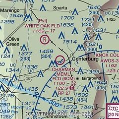
| Sectional chart |
|---|
|
| Airport distance calculator |
|---|
|
|
| Sunrise and sunset |
|---|
|
Times for 07-Jun-2026
| | Local
(UTC-4) | | Zulu
(UTC) |
|---|
| Morning civil twilight | | 05:30 | | 09:30 |
| Sunrise | | 06:02 | | 10:02 |
| Sunset | | 20:57 | | 00:57 |
| Evening civil twilight | | 21:30 | | 01:30 |
|
| Current date and time |
|---|
| Zulu (UTC) | 07-Jun-2026 15:14:40 |
|---|
| Local (UTC-4) | 07-Jun-2026 11:14:40 |
|---|
|
| METAR |
|---|
K4I3
10nm E | 071455Z AUTO VRB01KT 10SM CLR 25/22 A3001 RMK AO2
|
KDLZ
18nm W | 071455Z AUTO VRB03KT 10SM CLR 26/22 A3000 RMK AO2
|
KCMH
19nm S | 071451Z 03004KT 10SM SCT017 BKN250 26/21 A2999 RMK AO2 SLP147 T02560206 51007 $
|
|
| TAF |
|---|
KCMH
19nm S | 071129Z 0712/0812 33004KT P6SM SCT030 BKN250 FM071800 03007KT P6SM FEW050 FM080000 06004KT P6SM SCT250
|
|
| NOTAMs |
|---|
NOTAMs are issued by the DoD/FAA and will open in a separate window not controlled by AirNav.
|
|


