FAA INFORMATION EFFECTIVE 14 MAY 2026
Location
| FAA Identifier: | 4I3 |
| Lat/Long: | 40-19-44.0820N 082-31-33.8540W
40-19.734700N 082-31.564233W
40.3289117,-82.5260706
(estimated) |
| Elevation: | 1191.6 ft. / 363.2 m (surveyed) |
| Variation: | 06W (1990) |
| From city: | 4 miles SW of MOUNT VERNON, OH |
| Time zone: | UTC -4 (UTC -5 during Standard Time) |
| Zip code: | 43050 |
Airport Operations
| Airport use: | Open to the public |
| Control tower: | no |
| ARTCC: | INDIANAPOLIS CENTER |
| FSS: | CLEVELAND FLIGHT SERVICE STATION |
| NOTAMs facility: | 4I3 (NOTAM-D service available) |
| Attendance: | MON-FRI 0700-1700, ALL SAT-SUN 0900-1700
24 HR PN FOR ATNDNC AFT HRS - CALL AMGR. |
| Pattern altitude: | 1999.6 ft. MSL |
| Wind indicator: | lighted |
| Segmented circle: | no |
| Lights: | ACTVT REIL RWY 10 & 28; MIRL RWY 10/28 - CTAF. PAPI RWY 10 & 28 OPR CONSLY. |
| Beacon: | white-green (lighted land airport)
Operates sunset to sunrise. |
Airport Communications
| CTAF/UNICOM: | 123.05 |
| WX AWOS-3PT: | 126.05 (740-397-6297) |
| COLUMBUS APPROACH: | 125.95 |
| COLUMBUS DEPARTURE: | 125.95 |
| CLEARANCE DELIVERY: | 119.45 |
| IC: | 125.95 |
| WX ASOS at VTA (18 nm S): | 121.125 (740-522-1066) |
| WX AWOS-3PT at 4I9 (19 nm NW): | 121.4 (419-947-1039) |
Nearby radio navigation aids
| VOR radial/distance | | VOR name | | Freq | | Var |
|---|
| APEr021/11.0 | | APPLETON VORTAC | | 116.70 | | 06W |
| BUDr130/(30.0) | | BUCKEYE VOR | | 109.80 | | 05W |
Airport Services
| Fuel available: | 100LL JET-A+
100LL:FUEL AVBL H24 SELF SER VIA CREDIT CARD. |
| Parking: | hangars and tiedowns |
| Airframe service: | MAJOR |
| Powerplant service: | MAJOR |
| Bottled oxygen: | NONE |
| Bulk oxygen: | NONE |
Runway Information
Runway 10/28
| Dimensions: | 5504 x 100 ft. / 1678 x 30 m |
| Surface: | asphalt/grooved, in good condition |
| Weight bearing capacity: | | Single wheel: | 55.0 | | Double wheel: | 100.0 |
|
| Runway edge lights: | medium intensity |
| RUNWAY 10 | | RUNWAY 28 |
| Latitude: | 40-19.795312N | | 40-19.674050N |
| Longitude: | 082-32.151110W | | 082-30.977387W |
| Elevation: | 1187.3 ft. | | 1184.4 ft. |
| Traffic pattern: | left | | left |
| Runway heading: | 104 magnetic, 098 true | | 284 magnetic, 278 true |
| Markings: | nonprecision, in good condition | | nonprecision, in good condition |
| Visual slope indicator: | 4-light PAPI on left (3.00 degrees glide path) | | 4-light PAPI on left (3.00 degrees glide path) |
| Runway end identifier lights: | yes | | yes |
| Touchdown point: | yes, no lights | | yes, no lights |
| Obstructions: | 126 ft. trees, 3188 ft. from runway, 60 ft. left of centerline, 23:1 slope to clear | | 51 ft. trees, 1962 ft. from runway, 65 ft. left of centerline, 34:1 slope to clear |
Airport Ownership and Management from official FAA records
| Ownership: | Publicly-owned |
| Owner: | KNOX CO ARPT AUTHORITY
6481 KINNEY RD
MOUNT VERNON, OH 43050-9301
Phone 740-397-9647 |
| Manager: | JOSH WYNN
6481 KINNEY RD
MOUNT VERNON, OH 43050-9301
Phone 740-397-9647
KNOXAIRPORT@EMBARQMAIL.COM. |
Additional Remarks
| - | DEER, BIRDS, & OTR WILDLIFE ON & INVOF ARPT. |
Instrument Procedures
NOTE: All procedures below are presented as PDF files. If you need a reader for these files, you should download the free Adobe Reader.NOT FOR NAVIGATION. Please procure official charts for flight.
FAA instrument procedures published for use from 14 May 2026 at 0901Z to 11 June 2026 at 0900Z.
IAPs - Instrument Approach Procedures |
|---|
| RNAV (GPS) RWY 10 | |
download (205KB) |
| RNAV (GPS) RWY 28 | |
download (192KB) |
| VOR-A | |
download (159KB) |
| NOTE: Special Alternate Minimums apply | |
download (61KB) |
| NOTE: Special Take-Off Minimums/Departure Procedures apply | |
download (164KB) |
Other nearby airports with instrument procedures:
KVTA - Licking County Regional Airport (18 nm S)
4I9 - Morrow County Airport (19 nm NW)
KCMH - John Glenn Columbus International Airport (26 nm SW)
KGQQ - Galion Municipal Airport (27 nm N)
KDLZ - Delaware Municipal Airport - Jim Moore Field (27 nm W)
|
|

Road maps at:
MapQuest
Bing
Google
| Aerial photo |
|---|
WARNING: Photo may not be current or correct
 Photo by James Flack
Photo taken 05-Aug-2015
looking north.
Photo by James Flack
Photo taken 05-Aug-2015
looking north.
Do you have a better or more recent aerial photo of Knox County Airport that you would like to share? If so, please send us your photo.
|
| Sectional chart |
|---|
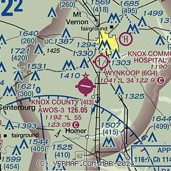
|
| Airport distance calculator |
|---|
|
|
| Sunrise and sunset |
|---|
|
Times for 06-Jun-2026
| | Local
(UTC-4) | | Zulu
(UTC) |
|---|
| Morning civil twilight | | 05:29 | | 09:29 |
| Sunrise | | 06:02 | | 10:02 |
| Sunset | | 20:56 | | 00:56 |
| Evening civil twilight | | 21:29 | | 01:29 |
|
| Current date and time |
|---|
| Zulu (UTC) | 06-Jun-2026 23:32:30 |
|---|
| Local (UTC-4) | 06-Jun-2026 19:32:30 |
|---|
|
| METAR |
|---|
| K4I3 | 062315Z AUTO VRB05KT 10SM SCT110 24/22 A2990 RMK AO2 LTG DSNT N AND E AND SW
|
KVTA
19nm S | 062254Z AUTO 21006KT 10SM SCT055 BKN070 22/20 A2991 RMK AO2 PK WND 25026/2202 LTG DSNT ALQDS RAB2155E27B37E48 TSB06E22 SLP122 P0010 T02170200
|
|
| TAF |
|---|
KCMH
26nm SW | 062128Z 0621/0718 23014G22KT P6SM VCTS SCT050CB BKN150 TEMPO 0621/0624 VRB25G35KT 1SM TSRA OVC040CB FM070100 25007KT P6SM BKN100 FM070700 28005KT P6SM BKN050 FM071400 35006KT P6SM BKN050
|
KMFD
29nm N | 061738Z 0618/0718 21008KT P6SM SCT050 BKN090 FM062200 26012KT P6SM VCSH BKN015 PROB30 0623/0701 5SM -TSRA BKN015CB FM070300 25006KT P6SM SCT015 BKN250 FM070700 31005KT P6SM BKN250 TEMPO 0709/0711 4SM BR
|
|
| NOTAMs |
|---|
NOTAMs are issued by the DoD/FAA and will open in a separate window not controlled by AirNav.
|
|


