FAA INFORMATION EFFECTIVE 16 APRIL 2026
Location
| FAA Identifier: | 76G |
| Lat/Long: | 42-43-16.9650N 082-35-46.5550W
42-43.282750N 082-35.775917W
42.7213792,-82.5962653
(estimated) |
| Elevation: | 613.8 ft. / 187 m (estimated) |
| Variation: | 06W (1985) |
| From city: | 4 miles W of MARINE CITY, MI |
| Time zone: | UTC -4 (UTC -5 during Standard Time) |
| Zip code: | 48039 |
Airport Operations
| Airport use: | Open to the public |
| Activation date: | 09/1942 |
| Control tower: | no |
| ARTCC: | CLEVELAND CENTER |
| FSS: | LANSING FLIGHT SERVICE STATION |
| NOTAMs facility: | LAN (NOTAM-D service available) |
| Attendance: | SAT-SUN ON CALL, ALL MON-FRI 0800-1700
FOR SVC CTC AMGR CELL. |
| Wind indicator: | lighted |
| Segmented circle: | yes |
| Lights: | ACTVT PAPI RWY 04 & 22; NSTD MIRL RWY 04/22 - CTAF. |
| Beacon: | white-green (lighted land airport)
Operates sunset to sunrise. |
Airport Communications
| CTAF/UNICOM: | 123.0 |
| WX AWOS-3P at PHN (12 nm N): | 118.375 (810-364-7787) |
Nearby radio navigation aids
| NDB name | | Hdg/Dist | | Freq | | Var | | ID |
|---|
| PHURN | | 187/7.3 | | 332 | | 07W | | PH | .--. .... |
Airport Services
| Fuel available: | 100LL |
| Parking: | hangars and tiedowns |
| Airframe service: | MAJOR |
| Powerplant service: | MAJOR |
Runway Information
Runway 4/22
| Dimensions: | 3070 x 60 ft. / 936 x 18 m |
| Surface: | asphalt, in good condition |
| Runway edge lights: | non-standard
NSTD MIRL DUE TO LCTN 23 FT FM RWY EDGE. |
| RUNWAY 4 | | RUNWAY 22 |
| Latitude: | 42-43.067667N | | 42-43.497833N |
| Longitude: | 082-35.955833W | | 082-35.596000W |
| Elevation: | 611.8 ft. | | 613.8 ft. |
| Traffic pattern: | left | | left |
| Runway heading: | 038 magnetic, 032 true | | 218 magnetic, 212 true |
| Displaced threshold: | no | | 295 ft. |
| Markings: | basic, in good condition | | basic, in good condition |
| Visual slope indicator: | 2-light PAPI on left (4.00 degrees glide path) | | 2-light PAPI on left (4.00 degrees glide path) |
| Runway end identifier lights: | no | | |
| Obstructions: | 100 ft. pline, marked, 2000 ft. from runway, 125 ft. left and right of centerline, 18:1 slope to clear
+12 FT TREE, 150 FT DIST, 125 FT L. | | none
+15 FT ROAD, 65 FT DIST, 125 FT L/R. |
Airport Ownership and Management from official FAA records
| Ownership: | Privately-owned |
| Owner: | 76G VENTURES, LLC
7115 MARINE CITY HWY
COTTRELLVILLE, MI 48039-1008
Phone 586-989-7633 |
| Manager: | PENNY FAUCHER
7115 MARINE CITY HWY
COTTRELLVILLE, MI 48039-1008
Phone 810-765-8289
CELL 810-650-7519. |
Additional Remarks
| - | FOR CD CTC SELFRIDGE APCH ON FREQ 119.6 OR CALL 586-239-5706, WHEN APCH CLSD CTC CLEVELAND ARTCC ON FREQ 132.25 OR CALL 440-774-0448/0490. |
| - | FOR FICONS CTC AMGR. |
| - | DEER & LRG BIRDS ON & INVOF ARPT. |
Instrument Procedures
There are no published instrument procedures at 76G.
Some nearby airports with instrument procedures:
KPHN - St Clair County International Airport (12 nm N)
KMTC - Selfridge Air National Guard Base (12 nm SW)
57D - Ray Community Airport (13 nm W)
D98 - Romeo State Airport (17 nm W)
KDET - Coleman A Young Municipal Airport (26 nm SW)
|
|

Road maps at:
MapQuest
Bing
Google
| Aerial photo |
|---|
WARNING: Photo may not be current or correct

Do you have a better or more recent aerial photo of Marine City Airport that you would like to share? If so, please send us your photo.
|
| Sectional chart |
|---|
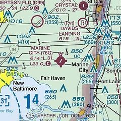
|
| Airport distance calculator |
|---|
|
|
| Sunrise and sunset |
|---|
|
Times for 25-Apr-2026
| | Local
(UTC-4) | | Zulu
(UTC) |
|---|
| Morning civil twilight | | 06:04 | | 10:04 |
| Sunrise | | 06:34 | | 10:34 |
| Sunset | | 20:22 | | 00:22 |
| Evening civil twilight | | 20:53 | | 00:53 |
|
| Current date and time |
|---|
| Zulu (UTC) | 25-Apr-2026 10:43:49 |
|---|
| Local (UTC-4) | 25-Apr-2026 06:43:49 |
|---|
|
| METAR |
|---|
KMTC
12nm SW | 251010Z AUTO 09004KT 3SM BR OVC002 09/09 A2975 RMK AO2 SLP080 $
|
KPHN
12nm N | 251015Z AUTO 00000KT 2 1/2SM BR OVC003 09/07 A2979 RMK AO2
|
CYZR
21nm NE | 251014Z AUTO 12002KT 9SM OVC008 08/07 A2978 RMK SLP091
|
|
| TAF |
|---|
KMTC
12nm SW | 241900Z 2419/2601 13012KT 9000 -SHRA SCT040 OVC050 QNH2968INS TEMPO 2422/2503 13015G25KT 8000 -TSRA BKN015CB BECMG 2503/2504 13010KT 8000 -SHRA BKN003 QNH2971INS BECMG 2515/2516 03010KT 9999 NSW OVC020 QNH2986INS TX21/2420Z TN09/2510Z LAST NO AMDS AFT 2503 NEXT 2511
|
|
| NOTAMs |
|---|
NOTAMs are issued by the DoD/FAA and will open in a separate window not controlled by AirNav.
|
|

