FAA INFORMATION EFFECTIVE 20 FEBRUARY 2025
Location
| FAA Identifier: | 77S |
| Lat/Long: | 43-55-50.7000N 123-00-24.0000W
43-55.845000N 123-00.400000W
43.9307500,-123.0066667
(estimated) |
| Elevation: | 541.2 ft. / 165.0 m (surveyed) |
| Variation: | 15E (2020) |
| From city: | 1 mile NE of CRESWELL, OR |
| Time zone: | UTC -8 (UTC -7 during Daylight Saving Time) |
| Zip code: | 97426 |
Airport Operations
| Airport use: | Open to the public |
| Control tower: | no |
| ARTCC: | SEATTLE CENTER |
| FSS: | MC MINNVILLE FLIGHT SERVICE STATION |
| NOTAMs facility: | MMV (NOTAM-D service available) |
| Attendance: | SAT-SUN 1100-1600, ALL MON-FRI 0900-1800 |
| Pattern altitude: | 1406.2 ft. MSL |
| Wind indicator: | lighted |
| Segmented circle: | yes |
| Lights: | ACTIVATE PAPI RWY 16 & 34; MIRL RWY 16/34.- CTAF. |
| Beacon: | white-green (lighted land airport)
Operates sunset to sunrise. |
Airport Communications
| CTAF/UNICOM: | 122.7 |
| WX AWOS-3: | 119.275 (541 895 2349) |
| CASCADE APPROACH: | 119.6 |
| CASCADE DEPARTURE: | 119.6 |
| WX ASOS at EUG (15 nm NW): | PHONE 541-461-3114 |
- APCH/DEP CTL SVC PRVDD BY SEATTLE ARTCC (ZSE) ON FREQS 125.8/291.7 (HORTON RCAG) WHEN CASCADE APCH CTL (EUG) CLSD.
Nearby radio navigation aids
| VOR radial/distance | | VOR name | | Freq | | Var |
|---|
| EUGr126/14.7 | | EUGENE VORTAC | | 112.90 | | 15E |
| CVOr142/36.3 | | CORVALLIS VOR/DME | | 115.40 | | 18E |
Airport Services
| Fuel available: | 100LL JET-A
100LL:SELF SERVE FUEL AVAILABLE 24 HRS. |
| Parking: | tiedowns |
| Airframe service: | MAJOR |
| Powerplant service: | MAJOR |
| Bottled oxygen: | NONE |
| Bulk oxygen: | NONE |
Runway Information
Runway 16/34
| Dimensions: | 3102 x 60 ft. / 945 x 18 m |
| Surface: | asphalt, in excellent condition |
| Weight bearing capacity: | |
| Runway edge lights: | medium intensity |
| RUNWAY 16 | | RUNWAY 34 |
| Latitude: | 43-56.099805N | | 43-55.591840N |
| Longitude: | 123-00.436585W | | 123-00.364823W |
| Elevation: | 541.2 ft. | | 535.3 ft. |
| Traffic pattern: | left | | left |
| Runway heading: | 159 magnetic, 174 true | | 339 magnetic, 354 true |
| Markings: | nonprecision, in good condition | | nonprecision, in good condition |
| Visual slope indicator: | 2-light PAPI on left (3.60 degrees glide path) | | 2-light PAPI on left (4.00 degrees glide path)
UNUSBL BYD 5 DEG RIGHT AND LEFT OF CNTRLN & BYD 1.5 NM FM THR. |
| Runway end identifier lights: | yes | | yes |
| Touchdown point: | yes, no lights | | yes, no lights |
| Obstructions: | 13 ft. tree, 248 ft. from runway, 125 ft. right of centerline, 3:1 slope to clear | | 64 ft. trees, 546 ft. from runway, 175 ft. left of centerline, 5:1 slope to clear |
Airport Ownership and Management from official FAA records
| Ownership: | Publicly-owned |
| Owner: | CITY OF CRESWELL
PO BOX 276
CRESWELL, OR 97426
Phone 541-895-2531 |
| Manager: | SHELLY HUMBLE
83501 N. MELTON ROAD
CRESWELL, OR 97426
Phone 541-895-2913 |
Additional Remarks
| - | RWY 34 CALM WIND RWY. |
| - | PAEW ADJ TO RWY 16/34 WKENDS 0800-1600. |
| - | BIRDS ON AND INVOF ARPT. BE AWARE MOWING ADJ RWY16/34 WEEKDAYS. |
| - | BE AWARE OF SKYDIVERS XNG RWY. |
| - | PARACHUTE JUMP AREA LOCATED EAST SIDE OF ARPT. |
| - | CTC NUMBER FOR INFO AND UPDATES ABOUT SKYDIVING OPS 541-895-3029. |
| - | FOR CD CTC CASCADE APCH AT 541-607-4674/4675, WHEN APCH CLSD CTC SEATTLE ARTCC AT 253-351-3694. |
Instrument Procedures
NOTE: All procedures below are presented as PDF files. If you need a reader for these files, you should download the free Adobe Reader.NOT FOR NAVIGATION. Please procure official charts for flight.
FAA instrument procedures published for use from 20 February 2025 at 0901Z to 20 March 2025 at 0900Z.
IAPs - Instrument Approach Procedures |
|---|
| RNAV (GPS) RWY 16 | |
download (257KB) |
|
|---|
| HOBBY TWO (OBSTACLE) | |
download (263KB) |
| NOTE: Special Take-Off Minimums/Departure Procedures apply | |
download (525KB) |
Other nearby airports with instrument procedures:
KEUG - Mahlon Sweet Field Airport (15 nm NW)
KCVO - Corvallis Municipal Airport (36 nm N)
S12 - Albany Municipal Airport (42 nm N)
KRBG - Roseburg Regional Airport (44 nm S)
KSLE - McNary Field Airport (59 nm N)
|
|

Road maps at:
MapQuest
Bing
Google
| Aerial photo |
|---|
WARNING: Photo may not be current or correct

Do you have a better or more recent aerial photo of Hobby Field Airport that you would like to share? If so, please send us your photo.
|
| Sectional chart |
|---|
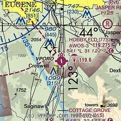
|
| Airport distance calculator |
|---|
|
|
| Sunrise and sunset |
|---|
|
Times for 21-Feb-2025
| | Local
(UTC-8) | | Zulu
(UTC) |
|---|
| Morning civil twilight | | 06:34 | | 14:34 |
| Sunrise | | 07:03 | | 15:03 |
| Sunset | | 17:49 | | 01:49 |
| Evening civil twilight | | 18:18 | | 02:18 |
|
| Current date and time |
|---|
| Zulu (UTC) | 21-Feb-2025 21:59:55 |
|---|
| Local (UTC-8) | 21-Feb-2025 13:59:55 |
|---|
|
| METAR |
|---|
| K77S | 212135Z AUTO 00000KT 10SM CLR 13/06 A3015 RMK A01
|
KEUG
15nm NW | 212154Z 12006KT 10SM FEW070 OVC110 13/06 A3015 RMK AO2 SLP209 T01280056
|
|
| TAF |
|---|
KEUG
15nm NW | 211732Z 2118/2218 18004KT P6SM BKN120 FM220000 19005KT P6SM -SHRA OVC070 FM220700 17007KT P6SM -SHRA SCT025 OVC035 FM221500 17008KT P6SM VCSH SCT035 BKN045
|
|
| NOTAMs |
|---|
NOTAMs are issued by the DoD/FAA and will open in a separate window not controlled by AirNav.
|
|


