FAA INFORMATION EFFECTIVE 14 MAY 2026
Location
| FAA Identifier: | 7A3 |
| Lat/Long: | 32-48-42.6360N 085-13-46.1510W
32-48.710600N 085-13.769183W
32.8118433,-85.2294864
(estimated) |
| Elevation: | 630.9 ft. / 192.3 m (surveyed) |
| Variation: | 05W (2025) |
| From city: | 3 miles SW of LANETT, AL |
| Time zone: | UTC -5 (UTC -6 during Standard Time) |
| Zip code: | 36863 |
Airport Operations
| Airport use: | Open to the public |
| Activation date: | 08/1959 |
| Control tower: | no |
| ARTCC: | ATLANTA CENTER |
| FSS: | ANNISTON FLIGHT SERVICE STATION |
| NOTAMs facility: | ANB (NOTAM-D service available) |
| Attendance: | ATTENDED 0800-1700 |
| Wind indicator: | lighted |
| Segmented circle: | yes |
| Lights: | ACTVT REIL RWY 06 & 24; MIRL RWY 06/24 - CTAF. |
| Beacon: | white-green (lighted land airport)
Operates sunset to sunrise. |
Airport Communications
| CTAF/UNICOM: | 122.8 |
| ATLANTA APPROACH: | 125.5 [0600-0000] |
| ATLANTA DEPARTURE: | 125.5 [0600-0000] |
| WX AWOS-3 at LGC (14 nm NE): | 126.325 (706-845-0677) |
| WX AWOS-3PT at AUO (16 nm SW): | 132.575 (334-501-0387) |
| WX AWOS-3PT at PIM (18 nm E): | 120.275 (706-663-2081) |
- ATLANTA LARGE TRACON PROVIDES APCH/DEP SVC 0615-2300 ON FREQ 125.5; ATLANTA ARTCC PROVIDES APCH/DEP SVC 2300-0615 ON FREQS 120.45/298.850 (COLUMBUS RCAG).
Nearby radio navigation aids
| VOR radial/distance | | VOR name | | Freq | | Var |
|---|
| LGCr184/14.3 | | LAGRANGE VORTAC | | 115.60 | | 01E |
| LSFr342/31.2 | | LAWSON VOR/DME | | 111.40 | | 05W |
| NDB name | | Hdg/Dist | | Freq | | Var | | ID |
|---|
| COWETA COUNTY | | 227/37.2 | | 234 | | 03W | | EQQ | . --.- --.- |
Airport Services
| Fuel available: | 100LL
100LL:FUEL 24 HR CREDIT CARD SVC AVBL. |
| Parking: | tiedowns |
| Airframe service: | NONE |
| Powerplant service: | NONE |
| Bottled oxygen: | NONE |
| Bulk oxygen: | NONE |
Runway Information
Runway 6/24
| Dimensions: | 5400 x 75 ft. / 1646 x 23 m |
| Surface: | concrete, in good condition |
| Runway edge lights: | medium intensity |
| RUNWAY 6 | | RUNWAY 24 |
| Latitude: | 32-48.439040N | | 32-48.982122N |
| Longitude: | 085-14.186927W | | 085-13.351400W |
| Elevation: | 607.2 ft. | | 630.9 ft. |
| Traffic pattern: | left | | left |
| Runway heading: | 057 magnetic, 052 true | | 237 magnetic, 232 true |
| Markings: | basic, in good condition | | basic, in good condition |
| Runway end identifier lights: | yes | | yes |
| Touchdown point: | yes, no lights | | yes, no lights |
| Obstructions: | 60 ft. fence, 1231 ft. from runway, 292 ft. right of centerline, 17:1 slope to clear | | 10 ft. tree, 293 ft. from runway, 107 ft. right of centerline, 9:1 slope to clear |
Airport Ownership and Management from official FAA records
| Ownership: | Publicly-owned |
| Owner: | CITY OF LANETT
401 N. LANIER AVE, 4445 51ST AVE SW
LANETT, AL 36863
Phone 334-644-2141 |
| Manager: | CRAIG STAPLETON
4445 51ST AVE SW, PO BOX 290
LANETT, AL 36863
Phone 334-476-3184
334-476-3184 |
Additional Remarks
| - | DEER ON & INVOF ARPT. |
| - | FOR CD CTC ATLANTA APCH AT 678-364-6132, WHEN APCH CLSD CTC ATLANTA ARTCC AT 770-210-7692. |
Instrument Procedures
NOTE: All procedures below are presented as PDF files. If you need a reader for these files, you should download the free Adobe Reader.NOT FOR NAVIGATION. Please procure official charts for flight.
FAA instrument procedures published for use from 14 May 2026 at 0901Z to 11 June 2026 at 0900Z.
IAPs - Instrument Approach Procedures |
|---|
| RNAV (GPS) RWY 06 | |
download (202KB) |
| RNAV (GPS) RWY 24 | |
download (207KB) |
| NOTE: Special Take-Off Minimums/Departure Procedures apply | |
download (513KB) |
Other nearby airports with instrument procedures:
KLGC - LaGrange-Callaway Airport (14 nm NE)
KAUO - Auburn University Regional Airport (16 nm SW)
KPIM - Harris County Airport (18 nm E)
KCSG - Columbus Airport (23 nm SE)
06A - Moton Field Municipal Airport (31 nm SW)
|
|

Road maps at:
MapQuest
Bing
Google
| Aerial photo |
|---|
WARNING: Photo may not be current or correct
 Photo by Regina Brown
Photo taken 22-Jun-2018
looking north-northwest.
Photo by Regina Brown
Photo taken 22-Jun-2018
looking north-northwest.
Do you have a better or more recent aerial photo of Lanett Regional Airport that you would like to share? If so, please send us your photo.
|
| Sectional chart |
|---|
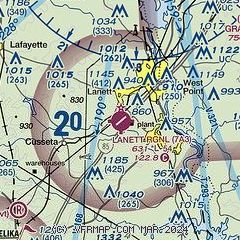
|
| Airport distance calculator |
|---|
|
|
| Sunrise and sunset |
|---|
|
Times for 26-May-2026
| | Local
(UTC-5) | | Zulu
(UTC) |
|---|
| Morning civil twilight | | 05:09 | | 10:09 |
| Sunrise | | 05:37 | | 10:37 |
| Sunset | | 19:39 | | 00:39 |
| Evening civil twilight | | 20:07 | | 01:07 |
|
| Current date and time |
|---|
| Zulu (UTC) | 27-May-2026 03:31:13 |
|---|
| Local (UTC-5) | 26-May-2026 22:31:13 |
|---|
|
| METAR |
|---|
KLGC
14nm NE | 262055Z AUTO 00000KT 10SM -RA SCT027 SCT046 BKN120 24/22 A3002 RMK AO2 P0012
|
KAUO
15nm SW | 270256Z AUTO 12003KT 10SM FEW003 21/ A3006 RMK AO2 RAB11E37 SLP170 P0000 60002 T0211 53006 $
|
KPIM
18nm E | 270315Z AUTO 12002KT 10SM CLR 22/22 A3008 RMK AO2
|
KCSG
23nm SE | 270251Z AUTO 14003KT 10SM CLR 22/22 A3005 RMK AO2 SLP171 60001 T02220217 53005 $
|
|
| TAF |
|---|
KAUO
15nm SW | 261911Z 2619/2718 18008KT P6SM SCT025 BKN035 TEMPO 2619/2623 2SM TSRA BR OVC008CB FM270000 14004KT P6SM BKN050 FM270400 15005KT P6SM OVC015 FM271000 12005KT P6SM OVC005 FM271500 16006KT P6SM OVC015
|
|
| NOTAMs |
|---|
NOTAMs are issued by the DoD/FAA and will open in a separate window not controlled by AirNav.
|
|

