FAA INFORMATION EFFECTIVE 11 JUNE 2026
Location
| FAA Identifier: | 7B4 |
| Lat/Long: | 39-53-04.2290N 082-35-20.5840W
39-53.070483N 082-35.343067W
39.8845081,-82.5890511
(estimated) |
| Elevation: | 930 ft. / 283 m (estimated) |
| Variation: | 05W (1985) |
| From city: | 3 miles NE of BALTIMORE, OH |
| Time zone: | UTC -4 (UTC -5 during Standard Time) |
| Zip code: | 43105 |
Airport Operations
| Airport use: | Open to the public |
| Activation date: | 06/1963 |
| Control tower: | no |
| ARTCC: | INDIANAPOLIS CENTER |
| FSS: | DAYTON FLIGHT SERVICE STATION |
| NOTAMs facility: | DAY (NOTAM-D service available) |
| Attendance: | SR-SS |
| Wind indicator: | lighted |
| Segmented circle: | no |
| Lights: | ACTVT NSTD LIRL - CALL AMGR. |
Airport Communications
| CTAF: | 122.9 |
| WX ASOS at LHQ (8 nm S): | 118.375 (740-681-1097) |
| WX ASOS at VTA (10 nm NE): | 121.125 (740-522-1066) |
| WX ASOS at CMH (15 nm NW): | 124.6 (614-333-9354) |
| WX AWOS-3 at LCK (16 nm W): | PHONE 614-492-2441 |
Nearby radio navigation aids
| VOR radial/distance | | VOR name | | Freq | | Var |
|---|
| APEr186/16.0 | | APPLETON VORTAC | | 116.70 | | 06W |
| XUBr045/(28.0) | | YELLOW BUD VOR | | 112.50 | | 05W |
| NDB name | | Hdg/Dist | | Freq | | Var | | ID |
|---|
| PICKL | | 096/11.4 | | 376 | | 07W | | LC | .-.. -.-. |
Airport Services
| Parking: | tiedowns |
| Airframe service: | NONE |
| Powerplant service: | NONE |
Runway Information
Runway 9/27
| Dimensions: | 3250 x 50 ft. / 991 x 15 m |
| Surface: | turf, in good condition |
| Runway edge lights: | non-standard
NSTD LIRL DUE TO RWY ENDS LGTD WITH SPLIT RED & GREEN LGTS & DTHRS LGTD WITH 1 SPLIT RED & GREEN LGT EACH SIDE OF RWY. |
| RUNWAY 9 | | RUNWAY 27 |
| Traffic pattern: | left | | left |
| Displaced threshold: | 270 ft.
DTHR MKD WITH GREEN LGT ON WHITE MKR. | | 275 ft.
DTHR MKD WITH GREEN LGT ON WHITE MKR. |
| Obstructions: | 8 ft. crops, 125 ft. both sides of centerline
APCH SLP 0:1 DUE TO +8 FT CROPS, 10 FT DIST, 50 FT L & 125 FT R, OBSTN CLNC SLP 11:1 TO DTHR DUE TO 85 FT TREES, 675 FT DIST, 125 FT L/R. | | 15 ft. tree, 125 ft. right of centerline
APCH SLP 0:1 DUE TO +15 FT TREE, 0 FT DIST, 120 FT R, OBSTN CLNC SLP 18:1 TO DTHR. |
Airport Ownership and Management from official FAA records
| Ownership: | Privately-owned |
| Owner: | EDWARD MILLER
455 STEMEN RD NW
BALTIMORE, OH 43105-9626
Phone 614-862-8129 |
| Manager: | CLARENCE "BUTCH" PRICE
155 STEMEN RD NW
BALTIMORE, OH 43105-9692
Phone 614-204-4366
BUTCH.PRICE67@GMAIL.COM. |
Additional Remarks
| - | OCNL UAS OPRG FM ARPT, CTAF MNTD, OVERFLY FLD TO ENTER TFC PAT. |
| - | FOR CD CTC COLUMBUS APCH AT 614-338-8537. |
| - | OCNL DEER, BIRDS, & OTR WILDLIFE ON & INVOF ARPT. |
Instrument Procedures
There are no published instrument procedures at 7B4.
Some nearby airports with instrument procedures:
KLHQ - Fairfield County Airport (8 nm S)
KVTA - Licking County Regional Airport (10 nm NE)
KCMH - John Glenn Columbus International Airport (15 nm NW)
KLCK - Rickenbacker International Airport (16 nm W)
I86 - Ed Newlon Field Airport (21 nm SE)
|
|

Road maps at:
MapQuest
Bing
Google
| Aerial photo |
|---|
WARNING: Photo may not be current or correct
 Photo by Denny Cox
Photo taken 04-Sep-2006
looking east
Photo by Denny Cox
Photo taken 04-Sep-2006
looking east
Do you have a better or more recent aerial photo of Miller Farm Landing Strip that you would like to share? If so, please send us your photo.
|
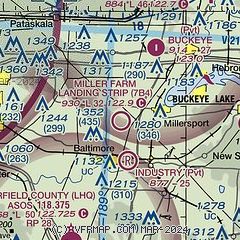
| Sectional chart |
|---|
|
| Airport distance calculator |
|---|
|
|
| Sunrise and sunset |
|---|
|
Times for 14-Jun-2026
| | Local
(UTC-4) | | Zulu
(UTC) |
|---|
| Morning civil twilight | | 05:30 | | 09:30 |
| Sunrise | | 06:02 | | 10:02 |
| Sunset | | 20:59 | | 00:59 |
| Evening civil twilight | | 21:32 | | 01:32 |
|
| Current date and time |
|---|
| Zulu (UTC) | 14-Jun-2026 21:24:53 |
|---|
| Local (UTC-4) | 14-Jun-2026 17:24:53 |
|---|
|
| METAR |
|---|
KLHQ
9nm SW | 142053Z AUTO 31020G39KT 10SM SCT037 SCT055 BKN065 26/19 A2975 RMK AO2 PK WND 32039/2053 PRESRR SLP065 T02610194 55007 TSNO
|
KVTA
10nm NE | 142104Z AUTO 32013G24KT 3SM RA BR SCT032 BKN060 OVC100 19/18 A2975 RMK AO2 LTG DSNT E P0003 T01940183
|
KCMH
15nm NW | 142057Z 33019G27KT 6SM -RA BR BKN012 BKN037 OVC047 19/18 A2976 RMK AO2 PK WND 33027/2055 TSE56 TS MOV SE P0000 T01940178 $
|
KLCK
16nm W | 142055Z AUTO 31012KT 5SM +RA BKN011 BKN036 OVC050 20/19 A2977 RMK AO2 LTG DSNT NE AND E P0019 60019 T02000190
|
|
| TAF |
|---|
KCMH
15nm NW | 141931Z 1420/1518 23012G21KT P6SM -SHRA BKN035 TEMPO 1420/1421 33013G35KT P6SM -TSRA BKN015CB FM142100 33012G23KT 5SM -SHRA BKN013 FM142200 32011G20KT P6SM FEW035 FM150300 31007KT P6SM FEW250
|
KLCK
16nm W | 141720Z 1418/1518 24012G21KT P6SM -SHRA BKN028 TEMPO 1420/1422 4SM -TSRA OVC008CB FM142200 33013G24KT P6SM -SHRA BKN009 FM142300 33012G23KT 6SM BR SCT013 FM150100 32011G20KT P6SM FEW035 FM150300 31007KT P6SM FEW250
|
|
| NOTAMs |
|---|
NOTAMs are issued by the DoD/FAA and will open in a separate window not controlled by AirNav.
|
|


