FAA INFORMATION EFFECTIVE 22 JANUARY 2026
Location
| FAA Identifier: | I86 |
| Lat/Long: | 39-41-29.7300N 082-11-52.0370W
39-41.495500N 082-11.867283W
39.6915917,-82.1977881
(estimated) |
| Elevation: | 1051.7 ft. / 320.6 m (surveyed) |
| Variation: | 07W (2010) |
| From city: | 2 miles S of NEW LEXINGTON, OH |
| Time zone: | UTC -5 (UTC -4 during Daylight Saving Time) |
| Zip code: | 43764 |
Airport Operations
| Airport use: | Open to the public |
| Control tower: | no |
| ARTCC: | INDIANAPOLIS CENTER |
| FSS: | CLEVELAND FLIGHT SERVICE STATION |
| NOTAMs facility: | CLE (NOTAM-D service available) |
| Attendance: | UNATNDD |
| Wind indicator: | lighted |
| Segmented circle: | no |
| Lights: | ACTVT REIL RWY 26; MIRL RWY 08/26 - CTAF. |
| Beacon: | white-green (lighted land airport)
Operates sunset to sunrise. |
Airport Communications
- APCH/DEP SVC PRVDD BY INDIANAPOLIS ARTCC ON FREQS 124.45/323.275 (ZANESVILLE RCAG).
Nearby radio navigation aids
| VOR radial/distance | | VOR name | | Freq | | Var |
|---|
| APEr153/32.9 | | APPLETON VORTAC | | 116.70 | | 06W |
| XUBr080/(37.4) | | YELLOW BUD VOR | | 112.50 | | 05W |
| NDB name | | Hdg/Dist | | Freq | | Var | | ID |
|---|
| UNIVERSITY | | 359/26.3 | | 250 | | 06W | | UGS | ..- --. ... |
Airport Services
| Parking: | hangars |
| Airframe service: | NONE |
| Powerplant service: | NONE |
| Bottled oxygen: | NONE |
| Bulk oxygen: | NONE |
Runway Information
Runway 8/26
| Dimensions: | 3498 x 75 ft. / 1066 x 23 m |
| Surface: | asphalt, in good condition |
| Runway edge lights: | medium intensity |
| RUNWAY 8 | | RUNWAY 26 |
| Latitude: | 39-41.407190N | | 39-41.583780N |
| Longitude: | 082-12.222172W | | 082-11.512390W |
| Elevation: | 1051.7 ft. | | 1041.8 ft. |
| Traffic pattern: | left | | left |
| Runway heading: | 079 magnetic, 072 true | | 259 magnetic, 252 true |
| Markings: | nonprecision, in good condition | | nonprecision, in good condition |
| Visual slope indicator: | 2-light PAPI on right (3.50 degrees glide path) | | 2-light PAPI on left (4.00 degrees glide path) |
| Runway end identifier lights: | no | | yes |
| Touchdown point: | yes, no lights | | yes, no lights |
| Obstructions: | 9 ft. fence, 287 ft. from runway, 19 ft. right of centerline, 9:1 slope to clear
+2-10 FT BRUSH, 0-125 FT DIST, 85 FT R. | | 44 ft. trees, 322 ft. from runway, 250 ft. right of centerline, 2:1 slope to clear
+8 FT FENCE, 0-124 FT DIST, 120-140 FT R. |
Airport Ownership and Management from official FAA records
| Ownership: | Publicly-owned |
| Owner: | PERRY COUNTY ARPT AUTH
COURTHOUSE, 105 N MAIN ST
NEW LEXINGTON, OH 43764-1262
Phone 330-687-2160 |
| Manager: | LAWRENCE NASH
1870 AIRPORT RD
NEW LEXINGTON, OH 43764-9681
Phone 740-605-1932 |
Additional Remarks
| - | DEER & TURKEYS ON & INVOF ARPT. |
| - | FOR CD CTC COLUMBUS APCH AT 614-338-8537. |
Instrument Procedures
NOTE: All procedures below are presented as PDF files. If you need a reader for these files, you should download the free Adobe Reader.NOT FOR NAVIGATION. Please procure official charts for flight.
FAA instrument procedures published for use from 22 January 2026 at 0901Z to 19 February 2026 at 0900z.
IAPs - Instrument Approach Procedures |
|---|
| RNAV (GPS) RWY 26 | |
download (222KB) |
| NOTE: Special Take-Off Minimums/Departure Procedures apply | |
download (478KB) |
Other nearby airports with instrument procedures:
KZZV - Zanesville Municipal Airport (21 nm NE)
KLHQ - Fairfield County Airport (22 nm W)
KVTA - Licking County Regional Airport (23 nm NW)
KUNI - Ohio University Airport (29 nm S)
I10 - Noble County Airport (31 nm E)
|
|

Road maps at:
MapQuest
Bing
Google
| Aerial photo |
|---|
WARNING: Photo may not be current or correct

Do you have a better or more recent aerial photo of Ed Newlon Field Airport that you would like to share? If so, please send us your photo.
|
| Sectional chart |
|---|
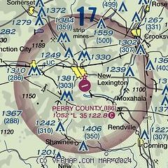
|
| Airport distance calculator |
|---|
|
|
| Sunrise and sunset |
|---|
|
Times for 06-Feb-2026
| | Local
(UTC-5) | | Zulu
(UTC) |
|---|
| Morning civil twilight | | 07:05 | | 12:05 |
| Sunrise | | 07:33 | | 12:33 |
| Sunset | | 17:53 | | 22:53 |
| Evening civil twilight | | 18:21 | | 23:21 |
|
| Current date and time |
|---|
| Zulu (UTC) | 06-Feb-2026 17:35:52 |
|---|
| Local (UTC-5) | 06-Feb-2026 12:35:52 |
|---|
|
| METAR |
|---|
KZZV
21nm NE | 061716Z AUTO 25005KT 3/4SM -SN BR FEW010 OVC016 M04/M06 A2966 RMK AO2 P0000 T10391056
|
KLHQ
22nm W | 061722Z AUTO 23006KT 3SM -SN BR BKN014 OVC022 M03/M06 A2967 RMK AO2 P0000 T10331056
|
KVTA
23nm NW | 061706Z AUTO 22007KT 2SM -SN BR BKN014 OVC020 M04/M06 A2966 RMK AO2 P0000 T10391061
|
KUNI
29nm S | 061635Z AUTO 30003KT 6SM -SN BR OVC011 M03/M03 A2969 RMK AO2 P0001 T10321035
|
KCDI
33nm NE | 061715Z AUTO 21003KT 1 1/2SM -SN OVC014 M03/M04 A2967 RMK AO2 T10301045
|
KLCK
34nm W | 061655Z AUTO 21004KT 1 1/4SM -SN SCT006 BKN014 OVC023 M03/M04 A2968 RMK AO2 T10281045
|
KCMH
37nm NW | 061701Z 23005KT 3SM BR BKN011 OVC017 M03/M06 A2967 RMK AO2 SFC VIS 4 SNE1657 P0000 T10331056
|
KRZT
41nm W | 061655Z AUTO 00000KT 1SM OVC003 M02/M02 A2970 RMK AO2 PWINO
|
K4I3
41nm N | 061715Z AUTO 27007KT 3SM UP BR FEW011 SCT050 M04/M05 A2964 RMK AO2
|
|
| TAF |
|---|
KZZV
21nm NE | 061553Z 0616/0712 21008KT 1 1/2SM -SN OVC020 FM062000 28008KT 5SM -SN OVC010 PROB30 0701/0704 30018G28KT 3/4SM -SHSN BKN008 FM070400 31015G27KT 6SM -SHSN BKN020 FM070700 32012G21KT P6SM SCT020 BKN050
|
|
| NOTAMs |
|---|
NOTAMs are issued by the DoD/FAA and will open in a separate window not controlled by AirNav.
|
|


