FAA INFORMATION EFFECTIVE 14 MAY 2026
Location
| FAA Identifier: | 7T7 |
| Lat/Long: | 31-51-18.3000N 102-04-26.2000W
31-51.305000N 102-04.436667W
31.8550833,-102.0739444
(estimated) |
| Elevation: | 2805 ft. / 855 m (estimated) |
| Variation: | 09E (1985) |
| From city: | 9 miles S of MIDLAND, TX |
| Time zone: | UTC -5 (UTC -6 during Standard Time) |
| Zip code: | 79706 |
Airport Operations
| Airport use: | Open to the public |
| Activation date: | 02/1976 |
| Control tower: | no |
| ARTCC: | FORT WORTH CENTER |
| FSS: | SAN ANGELO FLIGHT SERVICE STATION |
| NOTAMs facility: | SJT (NOTAM-D service available) |
| Attendance: | DAWN-DUSK |
| Wind indicator: | yes |
| Segmented circle: | yes |
| Lights: | SS-SR |
Airport Communications
| CTAF: | 122.9 |
| WX ASOS at MAF (8 nm NW): | PHONE 432-201-2813 |
| WX AWOS-3 at MDD (11 nm N): | 118.125 (432-687-4605) |
| WX ASOS at ODO (16 nm W): | 119.275 (432-363-9719) |
Nearby radio navigation aids
| VOR radial/distance | | VOR name | | Freq | | Var |
|---|
| MAFr136/11.0 | | MIDLAND VORTAC | | 112.60 | | 11E |
Airport Services
| Fuel available: | 100LL MOGAS
100LL:FUEL IS SELF SERVE. |
| Parking: | hangars and tiedowns |
| Airframe service: | MINOR |
| Powerplant service: | MAJOR |
Runway Information
Runway 16/34
| Dimensions: | 5000 x 42 ft. / 1524 x 13 m |
| Surface: | asphalt, in fair condition |
| Weight bearing capacity: | |
| Runway edge lights: | non-standard
NSTD SOLAR LIGHTS, 4 CLEAR LGTS EACH END. |
| Runway edge markings: | MRKGS NSTD DUE TO INCOR SIZE. EDGE REFLECTORS ENTR LEN. |
| RUNWAY 16 | | RUNWAY 34 |
| Latitude: | 31-51.847517N | | 31-51.052288N |
| Longitude: | 102-04.584158W | | 102-04.327465W |
| Elevation: | 2782.0 ft. | | 2805.0 ft. |
| Traffic pattern: | left | | left |
| Runway heading: | 156 magnetic, 165 true | | 336 magnetic, 345 true |
| Markings: | NSTD | | NSTD |
| Obstructions: | 10 ft. fence, 201 ft. from runway, 125 ft. left and right of centerline
7 FT FENCE 140 FT DSTC, 15 FT RD, 160 FT DSTC, 125 FT L/R. | | 8 ft. fence, 277 ft. from runway, 120 ft. right of centerline, 9:1 slope to clear
4 FT FENCE 170 FT DSTC, 125 FT L/R. |
Runway 6/24
| Dimensions: | 2800 x 45 ft. / 853 x 14 m |
| Surface: | asphalt, in fair condition |
| Runway edge markings: | MRKGS NSTD DUE TO INCOR SIZE. |
| RUNWAY 6 | | RUNWAY 24 |
| Latitude: | 31-50.990642N | | 31-51.106757N |
| Longitude: | 102-04.663697W | | 102-04.139903W |
| Elevation: | 2803.0 ft. | | 2805.0 ft. |
| Traffic pattern: | left | | left |
| Runway heading: | 066 magnetic, 075 true | | 246 magnetic, 255 true |
| Markings: | NSTD | | NSTD |
| Obstructions: | 5 ft. brush, 201 ft. from runway, 125 ft. left and right of centerline
5 FT FENCE, 0-199 FT DSTC, 70 FT L/R. | | 6 ft. brush, 201 ft. from runway, 125 ft. left and right of centerline
4 FT FENCE 0 FT DSTC. |
Airport Ownership and Management from official FAA records
| Ownership: | Privately-owned |
| Owner: | SKYWEST AIRPORT INC
10000 S CR 1210
MIDLAND, TX 79706
Phone 432-570-5983 |
| Manager: | AARON KINSEY
10306 S CR 1210
MIDLAND, TX 79706
Phone 432-682-5055 |
Additional Remarks
| - | DEER ON & INVOF ARPT. |
| - | FOR CD CTC MIDLAND APCH AT 432-563-2123. WHEN APCH CLSD CTC FORT WORTH ARTCC AT 817-858-7584. |
Instrument Procedures
There are no published instrument procedures at 7T7.
Some nearby airports with instrument procedures:
KMAF - Midland International Air and Space Port Airport (8 nm NW)
KMDD - Midland Airpark (11 nm N)
KODO - Odessa Airport-Schlemeyer Field (16 nm W)
KBPG - Big Spring/Mc Mahon-Wrinkle Airport (35 nm NE)
E11 - Andrews County Airport (37 nm NW)
|
|

Road maps at:
MapQuest
Bing
Google
| Aerial photo |
|---|
WARNING: Photo may not be current or correct
 Photo by Bryan Wilsak
Photo taken 06-Jul-2008
Photo by Bryan Wilsak
Photo taken 06-Jul-2008
Do you have a better or more recent aerial photo of Skywest Airport Inc. that you would like to share? If so, please send us your photo.
|
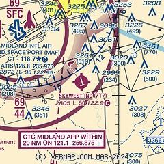
| Sectional chart |
|---|
|
| Airport distance calculator |
|---|
|
|
| Sunrise and sunset |
|---|
|
Times for 08-Jun-2026
| | Local
(UTC-5) | | Zulu
(UTC) |
|---|
| Morning civil twilight | | 06:15 | | 11:15 |
| Sunrise | | 06:43 | | 11:43 |
| Sunset | | 20:52 | | 01:52 |
| Evening civil twilight | | 21:20 | | 02:20 |
|
| Current date and time |
|---|
| Zulu (UTC) | 08-Jun-2026 10:51:03 |
|---|
| Local (UTC-5) | 08-Jun-2026 05:51:03 |
|---|
|
| METAR |
|---|
KMAF
9nm NW | 080953Z AUTO 18010KT 7SM CLR 23/21 A2985 RMK AO2 SLP054 T02330206 $
|
KMDD
11nm N | 081035Z AUTO 19011KT 10SM CLR 23/21 A2987 RMK AO2 T02340207
|
KODO
17nm W | 080953Z AUTO 19011KT 7SM CLR 23/21 A2986 RMK AO2 SLP056 T02330206
|
|
| TAF |
|---|
KMAF
9nm NW | 080520Z 0806/0906 18014KT P6SM FEW250
|
|
| NOTAMs |
|---|
NOTAMs are issued by the DoD/FAA and will open in a separate window not controlled by AirNav.
|
|


