FAA INFORMATION EFFECTIVE 17 APRIL 2025
Location
| FAA Identifier: | 7B3 |
| Lat/Long: | 42-57-40.5650N 070-49-48.5550W
42-57.676083N 070-49.809250W
42.9612681,-70.8301542
(estimated) |
| Elevation: | 93 ft. / 28 m (estimated) |
| Variation: | 16W (1985) |
| From city: | 2 miles N of HAMPTON, NH |
| Time zone: | UTC -4 (UTC -5 during Standard Time) |
| Zip code: | 03862 |
Airport Operations
| Airport use: | Open to the public |
| Activation date: | 02/1946 |
| Control tower: | no |
| ARTCC: | BOSTON CENTER |
| FSS: | BANGOR FLIGHT SERVICE STATION |
| NOTAMs facility: | BGR (NOTAM-D service available) |
| Attendance: | 0800-1600
EXC THANKSGIVING & CHRISTMAS. |
| Wind indicator: | lighted |
| Segmented circle: | no |
| Lights: | CTC AMGR AT 603-817-6617 FOR ACTVTN INSTRNS. |
Airport Communications
| CTAF/UNICOM: | 122.8 |
| WX ASOS at LWM (20 nm SW): | PHONE 978-687-8017 |
| WX ASOS at DAW (20 nm N): | 135.275 (603-332-7814) |
Nearby radio navigation aids
| VOR radial/distance | | VOR name | | Freq | | Var |
|---|
| ENEr216/29.4 | | KENNEBUNK VOR/DME | | 117.10 | | 17W |
| CONr130/36.2 | | CONCORD VOR/DME | | 112.90 | | 15W |
| BOSr027/36.9 | | BOSTON VOR/DME | | 112.70 | | 16W |
| NDB name | | Hdg/Dist | | Freq | | Var | | ID |
|---|
| ROLLINS | | 196/15.5 | | 260 | | 16W | | ESG | . ... --. |
Airport Services
| Fuel available: | 100LL MOGAS
100LL:SELF SVC 100LL & MOGAS AVBL 24 HRS VIA CREDIT CARD. |
| Parking: | hangars and tiedowns |
| Airframe service: | MAJOR |
| Powerplant service: | MINOR |
| Bottled oxygen: | NONE |
| Bulk oxygen: | NONE |
Runway Information
Runway 2/20
| Dimensions: | 2105 x 121 ft. / 642 x 37 m
RWY 02/20 2105 FT X 46 FT ASPH ON W PORTION, 2105 FT X 75 FT ON E PORTION. |
| Surface: | asphalt/turf, in excellent condition |
| Runway edge lights: | non-standard
NSTD LIRL. |
| RUNWAY 2 | | RUNWAY 20 |
| Latitude: | 42-57.502833N | | 42-57.849333N |
| Longitude: | 070-49.812000W | | 070-49.806500W |
| Elevation: | 86.0 ft. | | 93.0 ft. |
| Traffic pattern: | left | | left |
| Runway heading: | 017 magnetic, 001 true | | 197 magnetic, 181 true |
| Displaced threshold: | no | | 212 ft.
NSTD DTHR; SNGL RED/GREEN LGT EACH SIDE. THR SITING SFC 10:1 SLP. |
| Markings: | basic, in good condition | | basic, in good condition |
| Runway end identifier lights: | no | | no |
| Obstructions: | 56 ft. trees, 213 ft. from runway, 118 ft. left of centerline, 1:1 slope to clear
LOW GROWTH 110 FT L AND 50 FT R OF CNTRLN 100 FT FM RWY END. | | 55 ft. trees, 510 ft. from runway, 127 ft. right of centerline, 5:1 slope to clear
55 FT TREES 0+ FT FM RWY END R OF CNTRLN, 44 FT TREES 100 FT FM RWY END L OF CNTRLN. |
Airport Ownership and Management from official FAA records
| Ownership: | Privately-owned |
| Owner: | HAMPTON TCB, LLC
953 ISLINGTON STREET #23D
PORTSMOUTH, NH 03801
Phone 603-817-6617 |
| Manager: | GARRETT MILLER
9A LAFAYETTE RD
NORTH HAMPTON, NH 03862
Phone 603-964-6749 |
Additional Remarks
| - | WILDLIFE ON & INVOF ARPT. |
| - | ROAD AT RWY 20 THR WITH MOD VEHICLE TFC. |
| - | NMRS NORDO ACFT OPRG AT ARPT. |
| - | EXTSV STUDENT PILOT & TRNG OPS AT ARPT. |
| - | PARL RWY OPS NOT PMTD. PILOT WILL DESIGNATE & MAKE RADIO CALL TO ADZ TURF OR GRASS LNDG/TKOF. |
| - | CTN: SHORT & SOFT FLD OPS. FOR SHORT FLD TRNG OR INFO PLS CTC AMGR 603-817-6617. |
| - | FOR CD CTC BOSTON APCH AT 603-594-5552. |
Instrument Procedures
There are no published instrument procedures at 7B3.
Some nearby airports with instrument procedures:
KPSM - Portsmouth International Airport at Pease (7 nm N)
3B4 - Seacoast Airfield (11 nm N)
KLWM - Lawrence Municipal Airport (20 nm SW)
KDAW - Skyhaven Airport (20 nm N)
KBVY - Beverly Regional Airport (23 nm S)
|
|

Road maps at:
MapQuest
Bing
Google
| Aerial photo |
|---|
WARNING: Photo may not be current or correct
 Photo by Graeme J.W. Smith
Photo taken 09-Apr-2017
looking west.
Photo by Graeme J.W. Smith
Photo taken 09-Apr-2017
looking west.
Do you have a better or more recent aerial photo of Hampton Airfield that you would like to share? If so, please send us your photo.
|
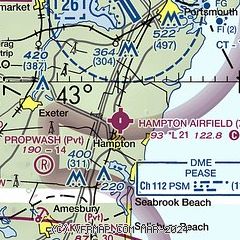
| Sectional chart |
|---|
|
| Airport distance calculator |
|---|
|
|
| Sunrise and sunset |
|---|
|
Times for 27-Apr-2025
| | Local
(UTC-4) | | Zulu
(UTC) |
|---|
| Morning civil twilight | | 05:13 | | 09:13 |
| Sunrise | | 05:44 | | 09:44 |
| Sunset | | 19:38 | | 23:38 |
| Evening civil twilight | | 20:09 | | 00:09 |
|
| Current date and time |
|---|
| Zulu (UTC) | 28-Apr-2025 00:41:38 |
|---|
| Local (UTC-4) | 27-Apr-2025 20:41:38 |
|---|
|
| METAR |
|---|
KPSM
6nm N | 272355Z 29010KT 10SM -RA BKN034 BKN070 08/03 A2986 RMK AO2A SLP115 P0000 60000 T00900028 52038
|
KDAW
20nm N | 272351Z AUTO 31014G24KT 10SM -RA OVC040 07/02 A2987 RMK AO2 PK WND 32026/2307 RAB2256 SLP113 P0001 60001 T00720022 10106 20067 51040 $
|
KLWM
20nm SW | 272354Z 32013G29KT 10SM SCT095 08/02 A2991 RMK AO2 PK WND 32029/2352 SLP128 60000 T00830017 10128 20078 53034
|
|
| TAF |
|---|
KPSM
6nm N | 271720Z 2718/2818 30015G24KT P6SM -RA FEW023 OVC035 FM272300 33010G18KT P6SM BKN050 FM280600 30009KT P6SM FEW250
|
|
| NOTAMs |
|---|
NOTAMs are issued by the DoD/FAA and will open in a separate window not controlled by AirNav.
|
|


