FAA INFORMATION EFFECTIVE 19 FEBRUARY 2026
Location
| FAA Identifier: | 8M1 |
| Lat/Long: | 34-35-30.7000N 088-38-54.6000W
34-35.511667N 088-38.910000W
34.5918611,-88.6485000
(estimated) |
| Elevation: | 392.2 ft. / 119.5 m (surveyed) |
| Variation: | 01W (2010) |
| From city: | 6 miles SW of central business district of the associated city |
| Time zone: | UTC -6 (UTC -5 during Daylight Saving Time) |
| Zip code: | 38824 |
Airport Operations
| Airport use: | Open to the public |
| Activation date: | 02/1968 |
| Control tower: | no |
| ARTCC: | MEMPHIS CENTER |
| FSS: | GREENWOOD FLIGHT SERVICE STATION |
| NOTAMs facility: | GWO (NOTAM-D service available) |
| Attendance: | 0800-1400 |
| Wind indicator: | lighted |
| Segmented circle: | yes |
| Lights: | ACTVT MIRL RWY 15/33 - CTAF. |
| Beacon: | white-green (lighted land airport)
Operates sunset to sunrise. |
Airport Communications
| CTAF/UNICOM: | 122.8 |
| WX AWOS-3PT at CRX (20 nm N): | 118.675 (662-287-5103) |
- APCH/DEP SVC PRVDD BY MEMPHIS ARTCC (TUPELO RCAG) ON FREQS 135.9/273.55.
Nearby radio navigation aids
| VOR radial/distance | | VOR name | | Freq | | Var |
|---|
| OTBr014/23.3 | | TUPELO VOR/DME | | 109.80 | | 04E |
Airport Services
| Fuel available: | 100LL JET-A
100LL:FUEL AVBL 24 HRS WITH CREDIT CARD. |
| Parking: | hangars and tiedowns |
| Bottled oxygen: | NONE |
| Bulk oxygen: | NONE |
Runway Information
Runway 15/33
| Dimensions: | 5003 x 75 ft. / 1525 x 23 m |
| Surface: | asphalt/grooved, in excellent condition |
| Weight bearing capacity: | |
| Runway edge lights: | medium intensity |
| RUNWAY 15 | | RUNWAY 33 |
| Latitude: | 34-35.856138N | | 34-35.168650N |
| Longitude: | 088-39.185198W | | 088-38.634162W |
| Elevation: | 392.0 ft. | | 375.0 ft. |
| Traffic pattern: | left | | left |
| Runway heading: | 148 magnetic, 147 true | | 328 magnetic, 327 true |
| Markings: | nonprecision, in good condition | | nonprecision, in good condition |
| Visual slope indicator: | 2-light PAPI on left (3.00 degrees glide path) | | 2-light PAPI on left (3.00 degrees glide path) |
| Runway end identifier lights: | yes | | yes |
| Touchdown point: | yes, no lights | | yes, no lights |
| Obstructions: | 58 ft. trees, 1360 ft. from runway, 300 ft. both sides of centerline, 20:1 slope to clear | | 105 ft. trees, 3269 ft. from runway, 800 ft. left of centerline, 29:1 slope to clear |
Airport Ownership and Management from official FAA records
| Ownership: | Publicly-owned |
| Owner: | BOONEVILLE & BALDWYN CITIES
CO OF PRENTISS, P.O. BOX 610
BOONEVILLE, MS 38829
Phone 662-210-1773
BALDWYN & COUNTY OF PRENTISS. TOMMY BARAGONA, CHAIRMAN ARPT BOARD. |
| Manager: | TERRY ROBERTS
178 CR 7450
BALDWYN, MS 38824
Phone 662-210-1773 |
Additional Remarks
| - | FOR CD CTC MEMPHIS ARTCC AT 901-368-8453/8449. |
| - | COURTESY VEHICLE AVBL. |
Instrument Procedures
NOTE: All procedures below are presented as PDF files. If you need a reader for these files, you should download the free Adobe Reader.NOT FOR NAVIGATION. Please procure official charts for flight.
FAA instrument procedures published for use from 19 February 2026 at 0901Z to 19 March 2026 at 0900Z.
IAPs - Instrument Approach Procedures |
|---|
| RNAV (GPS) RWY 15 | |
download (210KB) |
| RNAV (GPS) RWY 33 | |
download (215KB) |
| NOTE: Special Take-Off Minimums/Departure Procedures apply | |
download (116KB) |
Other nearby airports with instrument procedures:
M72 - New Albany/Union County Airport (19 nm W)
KCRX - Roscoe Turner Airport (20 nm N)
25M - Ripley Airport (20 nm NW)
KTUP - Tupelo Regional Airport (20 nm S)
15M - Segars Field Airport (26 nm NE)
|
|

Road maps at:
MapQuest
Bing
Google
| Aerial photo |
|---|
WARNING: Photo may not be current or correct
 Photo by Jeff Williams
Photo taken 15-Aug-2009
looking NW.
Photo by Jeff Williams
Photo taken 15-Aug-2009
looking NW.
Do you have a better or more recent aerial photo of Booneville/Baldwyn Airport that you would like to share? If so, please send us your photo.
|
| Sectional chart |
|---|
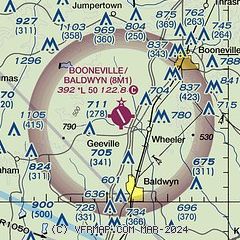
|
| Airport distance calculator |
|---|
|
|
| Sunrise and sunset |
|---|
|
Times for 08-Mar-2026
| | Local
(UTC-6) | | Zulu
(UTC) |
|---|
| Morning civil twilight | | 05:51 | | 11:51 |
| Sunrise | | 06:16 | | 12:16 |
| Sunset | | 17:55 | | 23:55 |
| Evening civil twilight | | 18:20 | | 00:20 |
|
| Current date and time |
|---|
| Zulu (UTC) | 08-Mar-2026 06:34:25 |
|---|
| Local (UTC-6) | 08-Mar-2026 00:34:25 |
|---|
|
| METAR |
|---|
KCRX
20nm N | 080615Z AUTO 00000KT 10SM OVC005 15/15 A3004 RMK AO2
|
KTUP
20nm S | 080553Z AUTO OVC010 RMK AO2 SLPNO 6//// 402830150 TSNO $
|
K01M
23nm E | 080615Z AUTO 00000KT 10SM DZ OVC004 15/15 A3003 RMK AO2 T01500150
|
KSZY
37nm N | 080615Z AUTO 00000KT 10SM 15/15 A3003 RMK A01
|
|
| TAF |
|---|
KTUP
20nm S | 080524Z 0806/0906 VRB03KT 5SM -SHRA BR OVC006 FM081800 34005KT P6SM OVC012 FM082200 27004KT P6SM BKN025 FM090300 00000KT P6SM OVC010 AMD NOT SKED
|
|
| NOTAMs |
|---|
NOTAMs are issued by the DoD/FAA and will open in a separate window not controlled by AirNav.
|
|

