FAA INFORMATION EFFECTIVE 22 JANUARY 2026
Location
| FAA Identifier: | 93C |
| Lat/Long: | 43-17-00.0870N 090-17-53.8150W
43-17.001450N 090-17.896917W
43.2833575,-90.2982819
(estimated) |
| Elevation: | 742 ft. / 226.2 m (surveyed) |
| Variation: | 02E (1980) |
| From city: | 4 miles SE of RICHLAND CENTER, WI |
| Time zone: | UTC -6 (UTC -5 during Daylight Saving Time) |
| Zip code: | 53581 |
Airport Operations
| Airport use: | Open to the public |
| Activation date: | 01/1947 |
| Control tower: | no |
| ARTCC: | CHICAGO CENTER |
| FSS: | GREEN BAY FLIGHT SERVICE STATION |
| NOTAMs facility: | GRB (NOTAM-D service available) |
| Attendance: | UNATNDD |
| Wind indicator: | lighted |
| Segmented circle: | yes |
| Lights: | ACTVT REIL RWY 17 & 35; PAPI RWY 17 & 35 - CTAF. MIRL RWY 17/35 PRESET TO LOW SS-SR; TO INCR INTST & ACTVT - CTAF. |
| Beacon: | white-green (lighted land airport)
Operates sunset to sunrise. |
Airport Communications
| CTAF: | 122.9 |
| WX ASOS at LNR (7 nm SE): | 119.425 (608-583-2576) |
| WX ASOS at OVS (18 nm SW): | 126.775 (608-375-2712) |
- APCH/DEP SVC PRVDD BY CHICAGO ARTCC ON FREQS 133.3/257.925 (LONE ROCK RCAG).
Nearby radio navigation aids
| VOR radial/distance | | VOR name | | Freq | | Var |
|---|
| DLLr232/28.3 | | DELLS VORTAC | | 117.00 | | 03E |
Airport Services
| Fuel available: | 100LL
100LL:SELF SVC FUEL AVBL H24 VIA CREDIT CARD. |
| Parking: | tiedowns |
| Airframe service: | NONE |
| Powerplant service: | NONE |
| Bottled oxygen: | NONE |
| Bulk oxygen: | NONE |
Runway Information
Runway 17/35
| Dimensions: | 3200 x 60 ft. / 975 x 18 m |
| Surface: | asphalt, in fair condition |
| Weight bearing capacity: | |
| Runway edge lights: | medium intensity |
| RUNWAY 17 | | RUNWAY 35 |
| Latitude: | 43-17.298333N | | 43-16.787167N |
| Longitude: | 090-18.016000W | | 090-17.841500W |
| Elevation: | 742.0 ft. | | 723.0 ft. |
| Traffic pattern: | left | | left |
| Runway heading: | 164 magnetic, 166 true | | 344 magnetic, 346 true |
| Markings: | nonprecision, in fair condition | | nonprecision, in fair condition |
| Visual slope indicator: | 2-light PAPI on left (3.50 degrees glide path) | | 2-light PAPI on left (3.50 degrees glide path) |
| Runway end identifier lights: | yes | | yes |
| Touchdown point: | yes, no lights | | yes, no lights |
| Obstructions: | 120 ft. trees, 1950 ft. from runway, 80 ft. left of centerline, 14:1 slope to clear | | none |
Runway 9/27
| Dimensions: | 1500 x 100 ft. / 457 x 30 m |
| Surface: | turf, in good condition |
| Runway edge markings: | MKD WITH WHITE & ORANGE PANELS AND YELLOW CONES. |
| RUNWAY 9 | | RUNWAY 27 |
| Latitude: | 43-16.912333N | | 43-16.914333N |
| Longitude: | 090-17.998000W | | 090-17.660000W |
| Elevation: | 717.0 ft. | | 728.0 ft. |
| Traffic pattern: | left | | left |
| Runway heading: | 088 magnetic, 090 true | | 268 magnetic, 270 true |
| Markings: | none | | none |
| Runway end identifier lights: | no | | no |
| Obstructions: | none | | 62 ft. trees, 870 ft. from runway, 140 ft. right of centerline, 14:1 slope to clear |
Airport Ownership and Management from official FAA records
| Ownership: | Publicly-owned |
| Owner: | CITY OF RICHLAND CENTER
450 S MAIN ST
RICHLAND CENTER, WI 53581
Phone 608-647-3466 |
| Manager: | JASEN GLASBRENNER
450 S MAIN ST
RICHLAND CENTER, WI 53581
Phone 608-647-3466 |
Additional Remarks
| - | ULTRALIGHT ACTVTY ON & IN VCNTY OF ARPT. |
| - | DEER ON & INVOF ARPT. |
| - | RWY 09/27 NOT PLOWED; CONDS UNMON. |
| - | FOR CD CTC CHICAGO ARTCC AT 630-906-8921. |
Instrument Procedures
NOTE: All procedures below are presented as PDF files. If you need a reader for these files, you should download the free Adobe Reader.NOT FOR NAVIGATION. Please procure official charts for flight.
FAA instrument procedures published for use from 22 January 2026 at 0901Z to 19 February 2026 at 0900z.
IAPs - Instrument Approach Procedures |
|---|
| RNAV (GPS)-A **CHANGED** | |
download (163KB) |
| NOTE: Special Take-Off Minimums/Departure Procedures apply | |
download (201KB) |
Other nearby airports with instrument procedures:
KLNR - Tri-County Regional Airport (7 nm SE)
KOVS - Boscobel Airport (18 nm SW)
C35 - Reedsburg Municipal Airport (20 nm NE)
91C - Sauk/Prairie Airport (24 nm E)
KMRJ - Iowa County Airport (24 nm S)
|
|

Road maps at:
MapQuest
Bing
Google
| Aerial photo |
|---|
WARNING: Photo may not be current or correct
 Photo by Mathieu Labs
Photo taken 21-Oct-2007
Photo by Mathieu Labs
Photo taken 21-Oct-2007
Do you have a better or more recent aerial photo of Richland Airport that you would like to share? If so, please send us your photo.
|
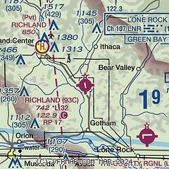
| Sectional chart |
|---|
|
| Airport distance calculator |
|---|
|
|
| Sunrise and sunset |
|---|
|
Times for 03-Feb-2026
| | Local
(UTC-6) | | Zulu
(UTC) |
|---|
| Morning civil twilight | | 06:46 | | 12:46 |
| Sunrise | | 07:16 | | 13:16 |
| Sunset | | 17:14 | | 23:14 |
| Evening civil twilight | | 17:45 | | 23:45 |
|
| Current date and time |
|---|
| Zulu (UTC) | 03-Feb-2026 22:51:04 |
|---|
| Local (UTC-6) | 03-Feb-2026 16:51:04 |
|---|
|
| METAR |
|---|
KLNR
6nm SE | 032156Z AUTO 35006KT 10SM CLR M05/M13 A3029 RMK AO2 SLP266 T10501133
|
|
| TAF |
|---|
KVOK
38nm N | 031700Z 0317/0423 VRB06KT 9999 SCT025 QNH3031INS BECMG 0417/0418 VRB06KT 9999 BKN080 620802 QNH3037INS TXM07/0317Z TNM17/0414Z LAST NO AMDS AFT 0322 NEXT 0409
|
KMSN
42nm E | 032057Z 0321/0418 01006KT P6SM SKC FM032300 VRB02KT P6SM SCT250
|
|
| NOTAMs |
|---|
NOTAMs are issued by the DoD/FAA and will open in a separate window not controlled by AirNav.
|
|

