FAA INFORMATION EFFECTIVE 25 DECEMBER 2025
Location
| FAA Identifier: | OVS |
| Lat/Long: | 43-09-38.9040N 090-40-26.3210W
43-09.648400N 090-40.438683W
43.1608067,-90.6739781
(estimated) |
| Elevation: | 672.8 ft. / 205.1 m (surveyed) |
| Variation: | 01W (2010) |
| From city: | 2 miles NE of BOSCOBEL, WI |
| Time zone: | UTC -6 (UTC -5 during Daylight Saving Time) |
| Zip code: | 53805 |
Airport Operations
| Airport use: | Open to the public |
| Activation date: | 01/1947 |
| Control tower: | no |
| ARTCC: | CHICAGO CENTER |
| FSS: | GREEN BAY FLIGHT SERVICE STATION |
| NOTAMs facility: | OVS (NOTAM-D service available) |
| Attendance: | UNATNDD |
| Wind indicator: | yes |
| Segmented circle: | no |
| Lights: | ACTVT REIL RWY 07 & 25; PAPI RWY 07 & 25; MIRL RWY 02/20 - CTAF. MIRL RWY 07/25 PRESET ON LOW INTST, TO INCR INTST & ACTVT - CTAF. |
| Beacon: | white-green (lighted land airport)
Operates sunset to sunrise. |
Airport Communications
| CTAF/UNICOM: | 122.8 |
| WX ASOS: | 126.775 (608-375-2712) |
- APCH/DEP SVC PRVDD BY CHICAGO ARTCC ON FREQS 133.3/257.925 (LONE ROCK RCAG).
Airport Services
| Fuel available: | 100LL
100LL:24 HR SELF SERVICE WITH CREDIT CARD. |
| Parking: | hangars and tiedowns |
| Airframe service: | MAJOR |
| Powerplant service: | MAJOR |
| Bottled oxygen: | NONE |
| Bulk oxygen: | NONE |
Runway Information
Runway 7/25
| Dimensions: | 5000 x 75 ft. / 1524 x 23 m |
| Surface: | asphalt, in good condition |
| Weight bearing capacity: | | Single wheel: | 12.5 | | Double wheel: | 30.0 |
|
| Runway edge lights: | medium intensity |
| RUNWAY 7 | | RUNWAY 25 |
| Latitude: | 43-09.623792N | | 43-09.944142N |
| Longitude: | 090-40.741197W | | 090-39.705628W |
| Elevation: | 668.2 ft. | | 670.7 ft. |
| Traffic pattern: | left | | left |
| Runway heading: | 068 magnetic, 067 true | | 248 magnetic, 247 true |
| Markings: | nonprecision, in good condition | | nonprecision, in good condition |
| Visual slope indicator: | 2-light PAPI on left (3.00 degrees glide path) | | 2-light PAPI on left (3.00 degrees glide path) |
| Runway end identifier lights: | yes | | yes |
| Touchdown point: | yes, no lights | | yes, no lights |
Runway 2/20
| Dimensions: | 3656 x 58 ft. / 1114 x 18 m |
| Surface: | asphalt, in good condition |
| Weight bearing capacity: | |
| Runway edge lights: | medium intensity |
| RUNWAY 2 | | RUNWAY 20 |
| Latitude: | 43-09.174967N | | 43-09.751217N |
| Longitude: | 090-40.852283W | | 090-40.613267W |
| Elevation: | 672.0 ft. | | 668.5 ft. |
| Traffic pattern: | left | | left |
| Runway heading: | 018 magnetic, 017 true | | 198 magnetic, 197 true |
| Markings: | basic, in good condition | | basic, in good condition |
| Runway end identifier lights: | no | | no |
| Touchdown point: | yes, no lights | | yes, no lights |
| Obstructions: | 10 ft. trees, 230 ft. from runway, 90 ft. right of centerline, 3:1 slope to clear | | 26 ft. trees, 405 ft. from runway, 100 ft. left of centerline, 7:1 slope to clear |
Airport Ownership and Management from official FAA records
| Ownership: | Publicly-owned |
| Owner: | CITY OF BOSCOBEL
1006 WISCONSIN AVE
BOSCOBEL, WI 53805
Phone 608-375-5001 |
| Manager: | GLENN GRISWOLD
1006 WISCONSIN AVE
BOSCOBEL, WI 53805
Phone 608-852-5046
EXT 140. ADDNL FONE 608-485-1258. |
Additional Remarks
| - | FOR CD CTC CHICAGO ARTCC AT 630-906-8921. |
| - | COLD TEMPERATURE AIRPORT. ALTITUDE CORRECTION REQUIRED AT OR BELOW -30C. |
Instrument Procedures
NOTE: All procedures below are presented as PDF files. If you need a reader for these files, you should download the free Adobe Reader.NOT FOR NAVIGATION. Please procure official charts for flight.
FAA instrument procedures published for use from 25 December 2025 at 0901z to 22 January 2026 at 0900z.
IAPs - Instrument Approach Procedures |
|---|
| RNAV (GPS) RWY 07 | |
download (225KB) |
| RNAV (GPS) RWY 25 | |
download (234KB) |
| NOTE: Special Alternate Minimums apply | |
download (127KB) |
| NOTE: Special Take-Off Minimums/Departure Procedures apply | |
download (504KB) |
Other nearby airports with instrument procedures:
93C - Richland Airport (18 nm NE)
KPDC - Prairie du Chien Municipal Airport (21 nm SW)
KLNR - Tri-County Regional Airport (22 nm E)
KMRJ - Iowa County Airport (25 nm SE)
Y51 - Viroqua Municipal Airport (27 nm N)
|
|

Road maps at:
MapQuest
Bing
Google
| Aerial photo |
|---|
WARNING: Photo may not be current or correct
 Photo by Andrew Nahas with Brian Gillaspie piloting
Photo taken 12-Sep-2013
looking south-southwest.
Photo by Andrew Nahas with Brian Gillaspie piloting
Photo taken 12-Sep-2013
looking south-southwest.
Do you have a better or more recent aerial photo of Boscobel Airport that you would like to share? If so, please send us your photo.
|
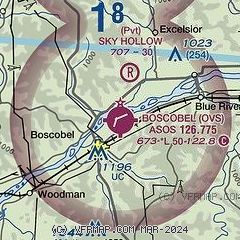
| Sectional chart |
|---|
|
| Airport distance calculator |
|---|
|
|
| Sunrise and sunset |
|---|
|
Times for 16-Jan-2026
| | Local
(UTC-6) | | Zulu
(UTC) |
|---|
| Morning civil twilight | | 07:01 | | 13:01 |
| Sunrise | | 07:32 | | 13:32 |
| Sunset | | 16:53 | | 22:53 |
| Evening civil twilight | | 17:24 | | 23:24 |
|
| Current date and time |
|---|
| Zulu (UTC) | 16-Jan-2026 20:06:51 |
|---|
| Local (UTC-6) | 16-Jan-2026 14:06:51 |
|---|
|
| METAR |
|---|
| KOVS | 161953Z AUTO 23007KT 10SM SCT020 BKN025 OVC060 02/M02 A2948 RMK AO2 SLP991 T00171017
|
|
| TAF |
|---|
KDBQ
46nm S | 161722Z 1618/1718 27017G25KT P6SM OVC040 FM162000 30020G28KT 4SM -SHSN OVC025 TEMPO 1621/1624 1SM -SHSN BR BKN015 FM170300 29016G24KT P6SM OVC022 PROB30 1703/1709 4SM -SN OVC030 FM171100 30014G22KT 3SM -SN BR OVC015
|
KVOK
49nm N | 161800Z 1618/1723 28010G20KT 9999 OVC020 620206 QNH2940INS TEMPO 1618/1704 9000 -SN OVC018 620186 TX01/1618Z TNM12/1712Z LAST NO AMDS AFT 1622 NEXT 1709
|
|
| NOTAMs |
|---|
NOTAMs are issued by the DoD/FAA and will open in a separate window not controlled by AirNav.
|
|

