FAA INFORMATION EFFECTIVE 09 JULY 2026
Location
| FAA Identifier: | DBQ |
| Lat/Long: | 42-24-07.2000N 090-42-34.1000W
42-24.120000N 090-42.568333W
42.4020000,-90.7094722
(estimated) |
| Elevation: | 1076.4 ft. / 328.1 m (surveyed) |
| Variation: | 03E (1975) |
| From city: | 7 miles SW of DUBUQUE, IA |
| Time zone: | UTC -5 (UTC -6 during Standard Time) |
| Zip code: | 52003 |
Airport Operations
| Airport use: | Open to the public |
| Activation date: | 03/1943 |
| Control tower: | yes |
| ARTCC: | CHICAGO CENTER |
| FSS: | FORT DODGE FLIGHT SERVICE STATION |
| NOTAMs facility: | DBQ (NOTAM-D service available) |
| Attendance: | 0600-2200 |
| Wind indicator: | lighted |
| Segmented circle: | no |
| Lights: | WHEN ATCT CLSD ACTVT MALSR RWYS 31 & 36; MALS RWY 13; REIL RWY 18; PAPI RWYS 13, 18, 31 & 36; HIRL RWYS 13/31 & 18/36 - CTAF. |
| Beacon: | white-green (lighted land airport)
ATC-CTL |
| Fire and rescue: | ARFF index A |
Airport Communications
| CTAF: | 119.5 |
| UNICOM: | 122.95 |
| ATIS: | 127.25 |
| WX ASOS: | PHONE 563-202-1292 |
| DUBUQUE GROUND: | 121.8 [0600-2200] |
| DUBUQUE TOWER: | 119.5 254.4 [0600-2200] |
- APCH/DEP SVC PRVDD BY CHICAGO ARTCC ON FREQS 133.95/281.4 (DUBUQUE RCAG).
Nearby radio navigation aids
| VOR radial/distance | | VOR name | | Freq | | Var |
|---|
| DBQ at field | | DUBUQUE VORTAC | | 115.80 | | 04E |
Airport Services
| Fuel available: | 100LL JET-A1+
100LL:FUEL SVC AVBL 24 HRS. FOR FUEL 2200-0500 CALL 563-589-4136. |
| Parking: | hangars and tiedowns |
| Airframe service: | MAJOR |
| Powerplant service: | MAJOR |
| Bottled oxygen: | HIGH |
| Bulk oxygen: | HIGH |
Runway Information
Runway 13/31
| Dimensions: | 6502 x 100 ft. / 1982 x 30 m |
| Surface: | concrete/grooved, in good condition |
| Weight bearing capacity: | | Single wheel: | 75.0 | | Double wheel: | 125.0 | | Double tandem: | 215.0 |
|
| Runway edge lights: | high intensity |
| RUNWAY 13 | | RUNWAY 31 |
| Latitude: | 42-24.558682N | | 42-23.802607N |
| Longitude: | 090-42.931023W | | 090-41.908645W |
| Elevation: | 1076.4 ft. | | 1062.2 ft. |
| Traffic pattern: | left | | left |
| Runway heading: | 132 magnetic, 135 true | | 312 magnetic, 315 true |
| Declared distances: | TORA:6502 TODA:6502 ASDA:6502 LDA:6502 | | TORA:6502 TODA:6502 ASDA:6502 LDA:6502 |
| Markings: | precision, in good condition | | precision, in good condition |
| Visual slope indicator: | 4-light PAPI on right (3.00 degrees glide path) | | 4-light PAPI on left (3.00 degrees glide path) |
| Approach lights: | MALS: 1,400 foot medium intensity approach lighting system | | MALSR: 1,400 foot medium intensity approach lighting system with runway alignment indicator lights |
| Touchdown point: | yes, no lights | | yes, no lights |
| Instrument approach: | | | LOC/DME |
| Obstructions: | none | | 122 ft. pole, lighted, 4475 ft. from runway, 50 ft. right of centerline, 35:1 slope to clear |
Runway 18/36
| Dimensions: | 6327 x 150 ft. / 1928 x 46 m |
| Surface: | concrete/grooved, in good condition |
| Weight bearing capacity: | | Single wheel: | 75.0 | | Double wheel: | 173.0 | | Double tandem: | 275.0 |
|
| Runway edge lights: | high intensity |
| RUNWAY 18 | | RUNWAY 36 |
| Latitude: | 42-24.577410N | | 42-23.535885N |
| Longitude: | 090-42.722360W | | 090-42.720965W |
| Elevation: | 1072.8 ft. | | 1033.4 ft. |
| Traffic pattern: | left | | left |
| Runway heading: | 177 magnetic, 180 true | | 357 magnetic, 360 true |
| Declared distances: | TORA:6327 TODA:6327 ASDA:6327 LDA:6327 | | TORA:6327 TODA:6327 ASDA:6327 LDA:6327 |
| Markings: | precision, in good condition | | precision, in good condition |
| Visual slope indicator: | 4-light PAPI on left (3.00 degrees glide path) | | 4-light PAPI on left (3.00 degrees glide path) |
| RVR equipment: | rollout | | touchdown |
| Approach lights: | | | MALSR: 1,400 foot medium intensity approach lighting system with runway alignment indicator lights |
| Runway end identifier lights: | yes | | |
| Touchdown point: | yes, no lights | | yes, no lights |
| Instrument approach: | | | ILS/DME |
Airport Ownership and Management from official FAA records
| Ownership: | Publicly-owned |
| Owner: | CITY OF DUBUQUE
11000 ARPT RD
DUBUQUE, IA 52003
Phone 563-589-4128 |
| Manager: | TODD DALSING
11000 AIRPORT ROAD
DUBUQUE, IA 52003
Phone 563-589-4136 |
Additional Remarks
| A39-18/36 | PCR VALUE: 440/R/D/W/T |
| A39-13/31 | PCR VALUE: 482/R/D/W/T |
| - | WATERFOWL ON & INVOF ARPT. |
| - | 100LL SELF SERVICE FUEL STATION AVBL AT T-HGRS 24HRS. AREA NOT VSB BY TWR. |
| - | ACFT DEPARTING RY 36, THE APCH ENDS OF RY 31 AND RY 18 ARE NOT VISIBLE FOR APRXLY THE FIRST 3000 FT OF TKOF ROLL. |
| - | FOR CD IF UNA TO CTC ON FSS FREQ, CTC CHICAGO ARTCC AT 630-906-8921. |
| - | DASHED TWY EDGE MARKING ADJ TO TWY A EDGE AND GA APN DEFINE THE MOVMT/NON-MOVMT AREA BNDRY. NON-MOVMT AREA BNDRY MARKING ON THE GA APNS ARE THE WINGTIP CLNC LINE - TOFA BNDRY. |
| - | PPR FOR UNSCHD ACR OPNS CALL AMGR (563) 589-4136. ARFF INDEX B LEVEL EQUIP IS PROVIDED. |
Instrument Procedures
NOTE: All procedures below are presented as PDF files. If you need a reader for these files, you should download the free Adobe Reader.NOT FOR NAVIGATION. Please procure official charts for flight.
FAA instrument procedures published for use from 09 July 2026 at 0901Z to 06 August 2026 at 0900Z.
IAPs - Instrument Approach Procedures |
|---|
| ILS OR LOC RWY 36 | |
download (273KB) |
| RNAV (GPS) RWY 13 **CHANGED** | |
download (255KB) |
| RNAV (GPS) RWY 18 | |
download (235KB) |
| RNAV (GPS) RWY 31 **CHANGED** | |
download (232KB) |
| RNAV (GPS) RWY 36 | |
download (311KB) |
| LOC RWY 31 | |
download (264KB) |
| VOR RWY 13 | |
download (265KB) |
| VOR RWY 31 | |
download (268KB) |
| VOR RWY 36 | |
download (207KB) |
| NOTE: Special Alternate Minimums apply **CHANGED** | |
download (145KB) |
| NOTE: Special Take-Off Minimums/Departure Procedures apply | |
download (429KB) |
Other nearby airports with instrument procedures:
KPVB - Platteville Municipal Airport (21 nm NE)
KOQW - Maquoketa Municipal Airport (21 nm S)
KMXO - Monticello Regional Airport (23 nm SW)
KSFY - Tri-Township Airport (34 nm SE)
KMRJ - Iowa County Airport (36 nm NE)
|
|

Road maps at:
MapQuest
Bing
Google
| Aerial photo |
|---|
WARNING: Photo may not be current or correct
 Taken in September 2007
Do you have a better or more recent aerial photo of Dubuque Regional Airport that you would like to share? If so, please send us your photo.
|
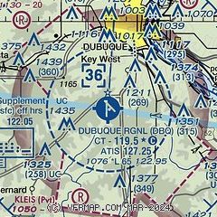
| Sectional chart |
|---|
|
 Download PDF
of official airport diagram from the FAA
| Airport distance calculator |
|---|
|
|
| Sunrise and sunset |
|---|
|
Times for 25-Jul-2026
| | Local
(UTC-5) | | Zulu
(UTC) |
|---|
| Morning civil twilight | | 05:17 | | 10:17 |
| Sunrise | | 05:49 | | 10:49 |
| Sunset | | 20:29 | | 01:29 |
| Evening civil twilight | | 21:02 | | 02:02 |
|
| Current date and time |
|---|
| Zulu (UTC) | 25-Jul-2026 08:46:19 |
|---|
| Local (UTC-5) | 25-Jul-2026 03:46:19 |
|---|
|
| METAR |
|---|
| KDBQ | 250828Z AUTO 18005KT 10SM BKN012 OVC019 19/18 A2999 RMK AO2 T01890178
|
|
| TAF |
|---|
| KDBQ | 250535Z 2506/2606 17006KT P6SM BKN040 FM250800 19007KT P6SM BKN030 FM251000 20005KT P6SM OVC015 TEMPO 2511/2514 4SM BR OVC006 FM251500 21006KT P6SM BKN020 FM251900 21008KT P6SM BKN030
|
|
| NOTAMs |
|---|
NOTAMs are issued by the DoD/FAA and will open in a separate window not controlled by AirNav.
|
|


