FAA INFORMATION EFFECTIVE 15 MAY 2025
Location
| FAA Identifier: | ACJ |
| Lat/Long: | 32-06-38.9000N 084-11-19.9000W
32-06.648333N 084-11.331667W
32.1108056,-84.1888611
(estimated) |
| Elevation: | 468.4 ft. / 142.8 m (surveyed) |
| Variation: | 04W (2010) |
| From city: | 4 miles NE of AMERICUS, GA |
| Time zone: | UTC -4 (UTC -5 during Standard Time) |
| Zip code: | 31709 |
Airport Operations
| Airport use: | Open to the public |
| Activation date: | 03/1941 |
| Control tower: | no |
| ARTCC: | ATLANTA CENTER |
| FSS: | MACON FLIGHT SERVICE STATION |
| NOTAMs facility: | MCN (NOTAM-D service available) |
| Attendance: | 0800-2000 |
| Wind indicator: | lighted |
| Segmented circle: | yes |
| Lights: | ACTVT HIRL RY 05/23, PAPI RY 05 & RY 23 AND MALSF RY 23 - CTAF. |
| Beacon: | white-green (lighted land airport)
Operates sunset to sunrise. |
Airport Communications
| CTAF/UNICOM: | 122.8 |
| WX AWOS-3: | 128.375 (770-847-7993) |
| ATLANTA APPROACH: | 124.2 |
| ATLANTA DEPARTURE: | 124.2 |
| CLEARANCE DELIVERY: | 119.95 |
- APCH/DEP SVC PRVDD BY ATLANTA LARGE TRACON 0615-2300. APCH/DEP SVC PRVDD BY ATLANTA ARTCC 2300-0615 ON FREQS 134.5/269.3 & CLNC DEL ON FREQ 134.5 (MACON RCAG).
Nearby radio navigation aids
| VOR radial/distance | | VOR name | | Freq | | Var |
|---|
| PZDr013/27.8 | | PECAN VOR/DME | | 116.10 | | 02W |
| VNAr259/35.7 | | VIENNA VORTAC | | 116.50 | | 01E |
| NDB name | | Hdg/Dist | | Freq | | Var | | ID |
|---|
| LINDBERGH | | 231/5.6 | | 242 | | 04W | | LKG | .-.. -.- --. |
| CONEY | | 298/18.0 | | 400 | | 06W | | OHY | --- .... -.-- |
Airport Services
| Fuel available: | 100LL JET-A |
| Parking: | tiedowns |
| Airframe service: | MAJOR |
| Powerplant service: | MAJOR |
| Bottled oxygen: | NONE |
| Bulk oxygen: | NONE |
Runway Information
Runway 5/23
| Dimensions: | 6011 x 100 ft. / 1832 x 30 m |
| Surface: | asphalt, in good condition |
| Weight bearing capacity: | | Single wheel: | 30.0 | | Double wheel: | 50.0 |
|
| Runway edge lights: | high intensity |
| RUNWAY 5 | | RUNWAY 23 |
| Latitude: | 32-06.262653N | | 32-06.953237N |
| Longitude: | 084-11.730760W | | 084-10.895192W |
| Elevation: | 468.3 ft. | | 458.5 ft. |
| Traffic pattern: | left | | left |
| Runway heading: | 050 magnetic, 046 true | | 230 magnetic, 226 true |
| Markings: | precision, in fair condition | | precision, in fair condition |
| Visual slope indicator: | 2-light PAPI on left (3.00 degrees glide path) | | 2-light PAPI on left (3.00 degrees glide path) |
| Approach lights: | | | MALSF: 1,400 foot medium intensity approach lighting system with sequenced flashers |
| Runway end identifier lights: | | | yes |
| Touchdown point: | yes, no lights | | yes, no lights |
| Instrument approach: | | | LOC/GS |
| Obstructions: | 37 ft. tree, 1070 ft. from runway, 565 ft. right of centerline, 23:1 slope to clear
SLOPE 28:1 TO RWY THLD. | | none |
Runway 10/28
| Dimensions: | 3786 x 75 ft. / 1154 x 23 m |
| Surface: | asphalt, in good condition |
| Weight bearing capacity: | |
| RUNWAY 10 | | RUNWAY 28 |
| Latitude: | 32-06.715463N | | 32-06.705623N |
| Longitude: | 084-11.727433W | | 084-10.993908W |
| Elevation: | 465.3 ft. | | 458.6 ft. |
| Traffic pattern: | left | | left |
| Runway heading: | 095 magnetic, 091 true | | 275 magnetic, 271 true |
| Markings: | basic, in good condition | | basic, in good condition |
| Touchdown point: | yes, no lights | | yes, no lights |
| Obstructions: | 35 ft. trees, 900 ft. from runway, 125 ft. left of centerline, 20:1 slope to clear | | 21 ft. trees, 767 ft. from runway, 48 ft. left of centerline, 27:1 slope to clear |
Airport Ownership and Management from official FAA records
| Ownership: | Publicly-owned |
| Owner: | SUMTER COUNTY
PO BOX 295, PO BOX 944
AMERICUS, GA 31709
Phone (229) 928-4500
AND AIRPORT AUTHORITY. |
| Manager: | TERRELL TEMPLIN, CHAIRMAN
233 FRANKIE WILLIAMS RD
AMERICUS, GA 31709
Phone 229-924-2813 |
Additional Remarks
| - | WILDLIFE ACTIVITY ON & INVOF ARPT. |
| - | FOR CD CTC ATLANTA APCH AT 678-364-6132, WHEN APCH CLSD CTC ATLANTA ARTCC AT 770-210-7692. |
Instrument Procedures
NOTE: All procedures below are presented as PDF files. If you need a reader for these files, you should download the free Adobe Reader.NOT FOR NAVIGATION. Please procure official charts for flight.
FAA instrument procedures published for use from 15 May 2025 at 0901Z to 13 June 2025 at 0900z.
IAPs - Instrument Approach Procedures |
|---|
| ILS OR LOC RWY 23 | |
download (286KB) |
| RNAV (GPS) RWY 05 | |
download (273KB) |
| RNAV (GPS) RWY 23 | |
download (292KB) |
| NOTE: Special Take-Off Minimums/Departure Procedures apply | |
download (191KB) |
Other nearby airports with instrument procedures:
53A - Dr. C P Savage Sr. Airport (15 nm NE)
KCKF - Crisp County-Cordele Airport (22 nm E)
16J - Dawson Municipal Airport (25 nm SW)
6A1 - Butler Municipal Airport (28 nm N)
KPXE - Perry-Houston County Airport (32 nm NE)
|
|

Road maps at:
MapQuest
Bing
Google
| Aerial photo |
|---|
WARNING: Photo may not be current or correct
 Photo courtesy of AirNav, LLC
Photo taken 03-Feb-2013
looking southeast.
Photo courtesy of AirNav, LLC
Photo taken 03-Feb-2013
looking southeast.
Do you have a better or more recent aerial photo of Jimmy Carter Regional Airport that you would like to share? If so, please send us your photo.
|
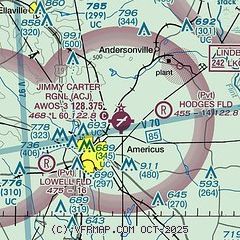
| Sectional chart |
|---|
|
| Airport distance calculator |
|---|
|
|
| Sunrise and sunset |
|---|
|
Times for 29-May-2025
| | Local
(UTC-4) | | Zulu
(UTC) |
|---|
| Morning civil twilight | | 06:05 | | 10:05 |
| Sunrise | | 06:33 | | 10:33 |
| Sunset | | 20:35 | | 00:35 |
| Evening civil twilight | | 21:03 | | 01:03 |
|
| Current date and time |
|---|
| Zulu (UTC) | 29-May-2025 09:29:38 |
|---|
| Local (UTC-4) | 29-May-2025 05:29:38 |
|---|
|
| METAR |
|---|
| KACJ | 290915Z AUTO 00000KT 10SM CLR 21/21 A3003 RMK AO2 T02140214
|
|
| TAF |
|---|
KABY
35nm S | 290535Z 2906/3006 24005KT P6SM SCT030 BKN100 FM291800 24007KT P6SM VCTS SCT040CB BKN100 TEMPO 2919/2923 VRB10G20KT 4SM TSRA OVC040CB FM300000 22005KT P6SM SCT030 BKN050 OVC100
|
KLSF
43nm W | 282100Z 2821/3003 23006KT 9999 VCSH SCT030 SCT050 QNH2999INS TEMPO 2822/2901 28009KT 8000 -SHRA VCTS BKN025CB BKN050 BECMG 2901/2902 25005KT 9999 NSW SCT025 SCT050 QNH3000INS BECMG 2907/2908 18005KT 8000 -SHRA BR BKN008 BKN020 QNH3001INS TEMPO 2910/2914 VRB10G15KT 6000 -TSRA BKN004 BKN015CB BECMG 2914/2915 30006KT 9999 VCSH SCT004 BKN015 QNH3002INS BECMG 2917/2918 18006KT 8000 -SHRA VCTS BKN015CB BKN040 QNH2999INS TX30/2921Z TN19/2912Z LAST NO AMDS AFT 2900 NEXT 2913
|
KWRB
43nm NE | 290800Z 2908/3014 24006KT 9999 FEW150 QNH3003INS BECMG 2914/2915 27009KT 9999 VCSH SCT015 BKN030 QNH3000INS TEMPO 2920/2924 6000 -TSRA BKN020CB BECMG 3000/3001 29006KT 9999 NSW OVC015 QNH2996INS TX29/2916Z TN22/2911Z
|
|
| NOTAMs |
|---|
NOTAMs are issued by the DoD/FAA and will open in a separate window not controlled by AirNav.
|
|


