FAA INFORMATION EFFECTIVE 15 MAY 2025
Location
| FAA Identifier: | AKR |
| Lat/Long: | 41-02-14.7250N 081-28-03.6650W
41-02.245417N 081-28.061083W
41.0374236,-81.4676847
(estimated) |
| Elevation: | 1067.3 ft. / 325.3 m (surveyed) |
| Variation: | 07W (1990) |
| From city: | 4 miles SE of AKRON, OH |
| Time zone: | UTC -4 (UTC -5 during Standard Time) |
| Zip code: | 44306 |
Airport Operations
| Airport use: | Open to the public |
| Activation date: | 11/1938 |
| Control tower: | no |
| ARTCC: | CLEVELAND CENTER |
| FSS: | CLEVELAND FLIGHT SERVICE STATION |
| NOTAMs facility: | AKR (NOTAM-D service available) |
| Attendance: | MON-FRI 0600-2200, ALL SAT-SUN 0800-2000 |
| Wind indicator: | lighted |
| Segmented circle: | no |
| Lights: | ACTVT REIL RWY 07 & 25; PAPI RWY 07 & 25; MIRL RWY 07/25 - CTAF. |
| Beacon: | white-green (lighted land airport)
ARPT BCN OPRS CONSLY. |
Airport Communications
| CTAF/UNICOM: | 123.075 |
| WX ASOS: | 126.825 (330-724-4237) |
| CLEVELAND APPROACH: | 125.5 |
| CLEVELAND DEPARTURE: | 125.5 |
| CLEARANCE DELIVERY: | 121.6 |
| BRWNZ STAR: | 126.55 |
| WX AWOS-2 at 1G3 (7 nm N): | 119.15 (330-346-1497) |
| WX ASOS at CAK (7 nm S): | PHONE 330-227-8682 |
| WX AWOS-3 at POV (14 nm NE): | 118.675 (330-298-9353) |
- APCH/DEP SVC PRVDD BY CLEVELAND APCH (CLE) 0600-0100. APCH/DEP SVC PRVDD BY CLEVELAND ARTCC (ZOB) ON FREQS 120.6/379.275 (MOUNT HOPE RCAG) 0100-0600.
Nearby radio navigation aids
| VOR radial/distance | | VOR name | | Freq | | Var |
|---|
| ACOr255/12.8 | | AKRON VOR/DME | | 114.40 | | 04W |
| BSVr359/17.9 | | BRIGGS VOR/DME | | 114.05 | | 04W |
| CXRr211/31.9 | | CHARDON VOR/DME | | 112.70 | | 05W |
| DJBr127/36.8 | | DRYER VOR/DME | | 113.60 | | 05W |
| NDB name | | Hdg/Dist | | Freq | | Var | | ID |
|---|
| AKRON | | 249/4.1 | | 362 | | 07W | | AK | .- -.- |
Airport Services
| Fuel available: | 100LL JET-A |
| Parking: | hangars and tiedowns |
| Airframe service: | MAJOR |
| Powerplant service: | MAJOR |
| Bottled oxygen: | NONE |
| Bulk oxygen: | HIGH/LOW |
Runway Information
Runway 7/25
| Dimensions: | 6336 x 150 ft. / 1931 x 46 m |
| Surface: | asphalt, in good condition |
| Weight bearing capacity: | | Single wheel: | 75.0 | | Double wheel: | 100.0 | | Double tandem: | 160.0 |
|
| Runway edge lights: | medium intensity |
| RUNWAY 7 | | RUNWAY 25 |
| Latitude: | 41-02.000177N | | 41-02.490598N |
| Longitude: | 081-28.669165W | | 081-27.452913W |
| Elevation: | 1067.3 ft. | | 1060.8 ft. |
| Traffic pattern: | left | | left |
| Runway heading: | 069 magnetic, 062 true | | 249 magnetic, 242 true |
| Displaced threshold: | 760 ft. | | 262 ft. |
| Markings: | nonprecision, in good condition | | nonprecision, in good condition |
| Visual slope indicator: | 4-light PAPI on left (3.60 degrees glide path) | | 4-light PAPI on left (4.00 degrees glide path) |
| Runway end identifier lights: | yes | | yes |
| Touchdown point: | yes, no lights | | yes, no lights |
| Instrument approach: | | | LOC/DME |
| Obstructions: | 23 ft. rr, 201 ft. from runway, 140 ft. right of centerline, 1:1 slope to clear
23 FT RAILROAD 0-200 FT FM, 155 FT L TO 140 FT RIGHT. | | 106 ft. tree, lighted, 1836 ft. from runway, 441 ft. left of centerline, 15:1 slope to clear
APCH RATIO 12:1 TO DSPLCD THR DUE TO +108 FT TREE 1310 FT FM THR 422 FT RIGHT. |
Airport Ownership and Management from official FAA records
| Ownership: | Publicly-owned |
| Owner: | CITY OF AKRON
166 S HIGH ST RM 701
AKRON, OH 44308-1627
Phone 330-375-2699 |
| Manager: | ANTHONY PLUCINSKI
1600 TRIPLETT BLVD
AKRON, OH 44306-3308
Phone 330-733-4760
TONYP@SUMMITAIRPORTSERVICES.COM. |
Additional Remarks
| - | FOR CD CTC CLEVELAND APCH AT 216-352-2323, WHEN APCH CLSD CTC CLEVELAND ARTCC AT 440-774-0223/0490. |
| - | DEER ON & INVOF ARPT. |
Instrument Procedures
NOTE: All procedures below are presented as PDF files. If you need a reader for these files, you should download the free Adobe Reader.NOT FOR NAVIGATION. Please procure official charts for flight.
FAA instrument procedures published for use from 15 May 2025 at 0901Z to 13 June 2025 at 0900z.
STARs - Standard Terminal Arrivals |
|---|
| BRWNZ FOUR (RNAV) | |
2 pages:
[1] [2] (448KB) |
| BRWNZ FOUR (RNAV), CONT.2 | |
download (235KB) |
| HUUVR ONE (RNAV) | |
download (169KB) |
| ZZIPS ONE (RNAV) | |
download (149KB) |
IAPs - Instrument Approach Procedures |
|---|
| RNAV (GPS) RWY 25 | |
download (220KB) |
| LOC RWY 25 | |
download (237KB) |
| NDB RWY 25 | |
download (217KB) |
| NOTE: Special Alternate Minimums apply | |
download (60KB) |
| NOTE: Special Take-Off Minimums/Departure Procedures apply | |
download (474KB) |
Other nearby airports with instrument procedures:
1G3 - Kent State University Airport (7 nm N)
KCAK - Akron-Canton Regional Airport (7 nm S)
3G3 - Wadsworth Municipal Airport (13 nm W)
KPOV - Portage County Airport (14 nm NE)
1G5 - Medina Municipal Airport (15 nm NW)
|
|

Road maps at:
MapQuest
Bing
Google
| Aerial photo |
|---|
WARNING: Photo may not be current or correct
 Photo by Zachariah Bates
Photo taken 04-Feb-2017
looking northwest.
Photo by Zachariah Bates
Photo taken 04-Feb-2017
looking northwest.
Do you have a better or more recent aerial photo of Akron Fulton International Airport that you would like to share? If so, please send us your photo.
|
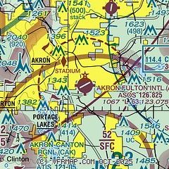
| Sectional chart |
|---|
|
CAUTION: Diagram may not be current
 Download PDF
of official airport diagram from the FAA
| Airport distance calculator |
|---|
|
|
| Sunrise and sunset |
|---|
|
Times for 25-May-2025
| | Local
(UTC-4) | | Zulu
(UTC) |
|---|
| Morning civil twilight | | 05:28 | | 09:28 |
| Sunrise | | 06:01 | | 10:01 |
| Sunset | | 20:45 | | 00:45 |
| Evening civil twilight | | 21:17 | | 01:17 |
|
| Current date and time |
|---|
| Zulu (UTC) | 25-May-2025 21:19:57 |
|---|
| Local (UTC-4) | 25-May-2025 17:19:57 |
|---|
|
| METAR |
|---|
| KAKR | 252054Z AUTO 32010G15KT 10SM FEW060 SCT075 18/04 A3019 RMK AO2 SLP225 T01830044 56010
|
KCAK
7nm S | 252051Z VRB05KT 10SM SCT055 SCT110 BKN170 18/07 A3020 RMK AO2 SLP227 T01830067 56012 $
|
KPOV
14nm NE | 252055Z AUTO 30009G14KT 260V330 10SM CLR 18/02 A3022 RMK AO2 T01800022 PWINO
|
|
| TAF |
|---|
KCAK
7nm S | 251740Z 2518/2618 33009KT P6SM BKN050 OVC090 FM260100 35003KT P6SM FEW250 FM261600 03009KT P6SM SCT045
|
|
| NOTAMs |
|---|
NOTAMs are issued by the DoD/FAA and will open in a separate window not controlled by AirNav.
|
|


