FAA INFORMATION EFFECTIVE 20 MARCH 2025
Location
| FAA Identifier: | AVO |
| Lat/Long: | 27-35-28.6796N 081-31-44.2806W
27-35.477993N 081-31.738010W
27.5912999,-81.5289668
(estimated) |
| Elevation: | 160.4 ft. / 48.9 m (surveyed) |
| Variation: | 05W (2010) |
| From city: | 2 miles W of AVON PARK, FL |
| Time zone: | UTC -4 (UTC -5 during Standard Time) |
| Zip code: | 33825 |
Airport Operations
| Airport use: | Open to the public |
| Activation date: | 04/1940 |
| Control tower: | no |
| ARTCC: | MIAMI CENTER |
| FSS: | SAINT PETERSBURG FLIGHT SERVICE STATION |
| NOTAMs facility: | PIE (NOTAM-D service available) |
| Attendance: | MON-FRI 0800-1600
ON CALL SAT & SUN. CTC (863) 453-3565 FOR SVC AFTER HRS. CLSD HOLIDAYS. |
| Wind indicator: | lighted |
| Segmented circle: | yes |
| Lights: | MIRL RWY 05/23 & 10/28 PRESET LOW INTST DUSK-DAWN; TO INCR INTST AND ACTVT TWY LGTS, REIL RWY 05 & 23, AND PAPI RWY 05, 10, 23 & 28, - CTAF. |
| Beacon: | white-green (lighted land airport)
Operates sunset to sunrise. |
Airport Communications
| CTAF/UNICOM: | 122.8 |
| WX AWOS-3: | 118.725 (863-453-4223) |
| WX AWOS-3 at SEF (13 nm SE): | 119.475 (863-655-6424) |
| WX AWOS-3 at X07 (19 nm N): | 124.225 (863-678-1334) |
| WX AWOS-2 at CHN (19 nm W): | 118.35 (863-767-0559) |
- APCH/DEP SVC PRVDD BY MIAMI ARTCC ON FREQS 134.55/257.7 (AVON PARK RCAG).
Nearby radio navigation aids
| VOR radial/distance | | VOR name | | Freq | | Var |
|---|
| LALr132/35.0 | | LAKELAND VORTAC | | 116.00 | | 01E |
Airport Services
| Fuel available: | 100LL JET-A |
| Parking: | hangars and tiedowns |
| Airframe service: | MAJOR |
| Powerplant service: | MAJOR |
| Bottled oxygen: | NONE |
| Bulk oxygen: | NONE |
Runway Information
Runway 5/23
| Dimensions: | 5374 x 100 ft. / 1638 x 30 m |
| Surface: | asphalt, in good condition |
| Weight bearing capacity: | | PCN 17 /F/B/X/T | | Single wheel: | 50.0 | | Double wheel: | 73.0 |
|
| Runway edge lights: | medium intensity |
| RUNWAY 5 | | RUNWAY 23 |
| Latitude: | 27-35.068915N | | 27-35.694263N |
| Longitude: | 081-32.108312W | | 081-31.402580W |
| Elevation: | 160.3 ft. | | 152.2 ft. |
| Traffic pattern: | left | | left |
| Runway heading: | 050 magnetic, 045 true | | 230 magnetic, 225 true |
| Displaced threshold: | no | | 1044 ft. |
| Markings: | nonprecision, in fair condition | | basic, in fair condition |
| Visual slope indicator: | 4-light PAPI on left (3.00 degrees glide path) | | 4-light PAPI on left (3.00 degrees glide path) |
| Runway end identifier lights: | yes | | yes |
| Touchdown point: | yes, no lights | | yes, no lights |
| Obstructions: | 16 ft. trees, 535 ft. from runway, 230 ft. left of centerline, 20:1 slope to clear | | 15 ft. road, 200 ft. from runway, 250 ft. right of centerline
RY 23, UNLGTD 15 FT ROAD; 90 FT FM END OF RWY, 250 FT RIGHT OF CNTRLN. |
Runway 10/28
| Dimensions: | 3844 x 75 ft. / 1172 x 23 m |
| Surface: | asphalt, in fair condition |
| Weight bearing capacity: | | PCN 30 /F/B/W/T | | Single wheel: | 78.0 | | Double wheel: | 119.0 |
|
| Runway edge lights: | medium intensity |
| Runway edge markings: | RWY 10/28 MARKINGS FADED. |
| RUNWAY 10 | | RUNWAY 28 |
| Latitude: | 27-35.613677N | | 27-35.611858N |
| Longitude: | 081-32.069630W | | 081-31.357635W |
| Elevation: | 153.4 ft. | | 152.2 ft. |
| Traffic pattern: | left | | left |
| Runway heading: | 095 magnetic, 090 true | | 275 magnetic, 270 true |
| Markings: | nonprecision, in poor condition | | basic, in poor condition |
| Visual slope indicator: | 4-light PAPI on left (3.00 degrees glide path) | | 4-light PAPI on left (3.00 degrees glide path) |
| Touchdown point: | yes, no lights | | yes, no lights |
| Obstructions: | 45 ft. trees, 1595 ft. from runway, 60 ft. right of centerline, 31:1 slope to clear | | 5 ft. fence, 221 ft. from runway, 200 ft. right of centerline, 4:1 slope to clear |
Airport Ownership and Management from official FAA records
| Ownership: | Publicly-owned |
| Owner: | CITY OF AVON PARK
110 EAST MAIN STREET
AVON PARK, FL 33825
Phone 863-452-4400
GARRETT ANDERSON 863-452-4400 |
| Manager: | MICHAEL POWELL
1545 STATE ROAD 64 WEST
AVON PARK, FL 33825
Phone 386-299-1712
AIRPORT PHYSICAL ADDRESS: 1545 STATE RD 64 WEST, AVON PARK, FL 33825 FAX: 863-452-4413 |
Additional Remarks
| - | FOR CD IF UNA TO CTC ON FSS FREQ, CTC MIAMI ARTCC AT 305-716-1731. |
| - | UNLGTD OBSTNS PRSNT IN THE APCH TO RY 23 DUE TO FENCE & ROAD 200 FT OF AER 23. |
Instrument Procedures
NOTE: All procedures below are presented as PDF files. If you need a reader for these files, you should download the free Adobe Reader.NOT FOR NAVIGATION. Please procure official charts for flight.
FAA instrument procedures published for use from 20 March 2025 at 0901Z to 17 April 2025 at 0900z.
IAPs - Instrument Approach Procedures |
|---|
| RNAV (GPS) RWY 05 | |
download (241KB) |
| RNAV (GPS) RWY 10 | |
download (214KB) |
| NOTE: Special Take-Off Minimums/Departure Procedures apply | |
download (405KB) |
Other nearby airports with instrument procedures:
KSEF - Sebring Regional Airport (13 nm SE)
X07 - Lake Wales Municipal Airport (19 nm N)
KCHN - Wauchula Municipal Airport (19 nm W)
KBOW - Bartow Executive Airport (25 nm NW)
X06 - Arcadia Municipal Airport (29 nm SW)
|
|

Road maps at:
MapQuest
Bing
Google
| Aerial photo |
|---|
WARNING: Photo may not be current or correct

Do you have a better or more recent aerial photo of Avon Park Executive Airport that you would like to share? If so, please send us your photo.
|
| Sectional chart |
|---|
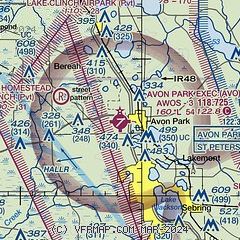
|
| Airport distance calculator |
|---|
|
|
| Sunrise and sunset |
|---|
|
Times for 14-Apr-2025
| | Local
(UTC-4) | | Zulu
(UTC) |
|---|
| Morning civil twilight | | 06:40 | | 10:40 |
| Sunrise | | 07:04 | | 11:04 |
| Sunset | | 19:49 | | 23:49 |
| Evening civil twilight | | 20:13 | | 00:13 |
|
| Current date and time |
|---|
| Zulu (UTC) | 15-Apr-2025 03:13:39 |
|---|
| Local (UTC-4) | 14-Apr-2025 23:13:39 |
|---|
|
| METAR |
|---|
KAGR
11nm E | 150255Z AUTO 24003KT 10SM FEW047 21/15 A3013 RMK AO2 SLP204 T02130149 52018 $
|
KSEF
13nm SE | 150255Z AUTO 28005KT 10SM 21/15 A3015 RMK AO2 T02140152
|
KX07
19nm N | 150255Z AUTO 31004KT FEW050 20/16 A3014 RMK A01
|
|
| TAF |
|---|
KLAL
34nm NW | 141744Z 1418/1518 24008KT P6SM SCT050 FM150000 VRB03KT P6SM SKC FM151300 26008KT P6SM FEW040
|
KISM
42nm N | 141720Z 1418/1518 20009KT P6SM SKC FM142300 VRB05KT P6SM SKC FM150500 24004KT P6SM SKC FM151500 26011G18KT P6SM SKC
|
|
| NOTAMs |
|---|
NOTAMs are issued by the DoD/FAA and will open in a separate window not controlled by AirNav.
|
|


