FAA INFORMATION EFFECTIVE 17 APRIL 2025
Location
| FAA Identifier: | BGE |
| Lat/Long: | 30-58-17.7531N 084-38-12.9401W
30-58.295885N 084-38.215668W
30.9715981,-84.6369278
(estimated) |
| Elevation: | 141.3 ft. / 43.1 m (surveyed) |
| Variation: | 04W (2010) |
| From city: | 6 miles NW of BAINBRIDGE, GA |
| Time zone: | UTC -4 (UTC -5 during Standard Time) |
| Zip code: | 39817 |
Airport Operations
| Airport use: | Open to the public |
| Activation date: | 10/1942 |
| Control tower: | no |
| ARTCC: | JACKSONVILLE CENTER |
| FSS: | MACON FLIGHT SERVICE STATION |
| NOTAMs facility: | MCN (NOTAM-D service available) |
| Attendance: | 0800-1800 |
| Wind indicator: | lighted |
| Segmented circle: | yes |
| Lights: | PAPI RWY 09 & 27 OPR CONSLY DUSK-2200. HIRL RWY 09/27 PRESET MED INTST DUSK-2200; TO INCR INTST - CTAF. AFTER 2200, ACTVT PAPI RWY 09 &27; HIRL RWY 09/27 - CTAF. MALSR RWY 27 - CTAF. |
| Beacon: | white-green (lighted land airport)
Operates sunset to sunrise. |
Airport Communications
| CTAF/UNICOM: | 122.975 |
| WX AWOS-3PT: | 121.125 (229-248-2104) |
| TALLAHASSEE APPROACH: | 128.7 [0645-2300] |
| TALLAHASSEE DEPARTURE: | 128.7 [0645-2300] |
| CLEARANCE DELIVERY: | 124.775 |
| WX AWOS-3PT at 17J (13 nm W): | 119.675 (229-524-0001) |
- APCH/DEP SVC PRVDD BY JACKSONVILLE ARTCC ON FREQS 128.625/379.175 (TALLAHASSEE RCAG) WHEN TALLAHASSEE APCH CTL CLSD.
Nearby radio navigation aids
| VOR radial/distance | | VOR name | | Freq | | Var |
|---|
| MAIr066/27.5 | | MARIANNA VORTAC | | 114.00 | | 00E |
| SZWr329/28.4 | | SEMINOLE VORTAC | | 117.50 | | 02E |
| NDB name | | Hdg/Dist | | Freq | | Var | | ID |
|---|
| WILLIS | | 274/5.8 | | 359 | | 04W | | LYZ | .-.. -.-- --.. |
| CAIDY | | 286/25.1 | | 338 | | 04W | | CYR | -.-. -.-- .-. |
Airport Services
| Fuel available: | 100LL JET-A+
100LL:SELF SVC FUEL 24 HRS WITH CREDIT CARD. |
| Oil available: | ALL ACFT OPERATING LOCALLY AT BGE MUST HAVE A TWO-WAY RADIO CAPABLE OF TRANSMITTING/RECEIVING ON CTAF FREQ; ONE-STOP TRANSIENT ACFT ARE EXEMPT FROM THIS REQUIREMENT. |
| Parking: | hangars and tiedowns |
| Airframe service: | MINOR |
| Powerplant service: | MINOR |
| Bottled oxygen: | NONE |
| Bulk oxygen: | NONE |
Runway Information
Runway 9/27
| Dimensions: | 5502 x 149 ft. / 1677 x 45 m |
| Surface: | asphalt, in good condition |
| Weight bearing capacity: | |
| Runway edge lights: | high intensity |
| RUNWAY 9 | | RUNWAY 27 |
| Latitude: | 30-58.369057N | | 30-58.373600N |
| Longitude: | 084-38.598017W | | 084-37.544770W |
| Elevation: | 141.3 ft. | | 128.8 ft. |
| Traffic pattern: | left | | left |
| Runway heading: | 094 magnetic, 090 true | | 274 magnetic, 270 true |
| Markings: | precision, in good condition | | precision, in good condition |
| Visual slope indicator: | 2-light PAPI on left (3.00 degrees glide path) | | 2-light PAPI on left (3.00 degrees glide path)
RWY 27 PAPI UNUSBL BYD 8 DEG RIGHT OF RCL. |
| Approach lights: | | | MALSR: 1,400 foot medium intensity approach lighting system with runway alignment indicator lights |
| Touchdown point: | yes, no lights | | yes, no lights |
| Instrument approach: | | | LOC/GS |
| Obstructions: | 51 ft. trees, 1475 ft. from runway, 557 ft. left of centerline, 25:1 slope to clear | | 93 ft. trees, 4478 ft. from runway, 606 ft. left of centerline, 46:1 slope to clear |
Runway 14/32
| Dimensions: | 5003 x 100 ft. / 1525 x 30 m |
| Surface: | asphalt, in fair condition |
| Weight bearing capacity: | |
| RUNWAY 14 | | RUNWAY 32 |
| Latitude: | 30-58.522167N | | 30-57.903667N |
| Longitude: | 084-38.691333W | | 084-38.057333W |
| Elevation: | 135.0 ft. | | 133.6 ft. |
| Traffic pattern: | left | | left |
| Runway heading: | 143 magnetic, 139 true | | 323 magnetic, 319 true |
| Markings: | basic, in fair condition | | basic, in fair condition |
| Touchdown point: | yes, no lights | | yes, no lights |
| Obstructions: | none | | 62 ft. trees, 1130 ft. from runway, 86 ft. left of centerline, 15:1 slope to clear |
Airport Ownership and Management from official FAA records
| Ownership: | Publicly-owned |
| Owner: | DECATUR COUNTY
PO BOX 726
BAINBRIDGE, GA 39818
Phone 229-248-2103 |
| Manager: | TOMMY JOHNSON
413 4TH RAMP
BAINBRIDGE, GA 39817
Phone 229-416-7776 |
Additional Remarks
| - | EXTENSIVE STUDENT PILOT TRNG ON AND INVOF ARPT. |
| - | FOR CD IF UNA ON FREQ CTC TALLAHASSEE APCH AT 850-942-8311. WHEN APCH CLSD, CTC JACKSONVILLE ARTCC AT 904-845-1592. |
Instrument Procedures
NOTE: All procedures below are presented as PDF files. If you need a reader for these files, you should download the free Adobe Reader.NOT FOR NAVIGATION. Please procure official charts for flight.
FAA instrument procedures published for use from 17 April 2025 at 0901Z to 15 May 2025 at 0900z.
IAPs - Instrument Approach Procedures |
|---|
| ILS OR LOC RWY 27 | |
download (248KB) |
| RNAV (GPS) RWY 09 | |
download (259KB) |
| RNAV (GPS) RWY 27 | |
download (281KB) |
| VOR-A | |
download (204KB) |
| NOTE: Special Alternate Minimums apply | |
download (153KB) |
| NOTE: Special Take-Off Minimums/Departure Procedures apply | |
download (189KB) |
Other nearby airports with instrument procedures:
17J - Donalsonville Municipal Airport (13 nm W)
2J9 - Quincy Municipal Airport (23 nm S)
KCXU - Camilla-Mitchell County Airport (25 nm NE)
70J - Cairo-Grady County Airport (25 nm E)
KBIJ - Early County Airport (29 nm NW)
|
|

Road maps at:
MapQuest
Bing
Google
| Aerial photo |
|---|
WARNING: Photo may not be current or correct
 Photo courtesy of AirNav, LLC
Photo taken 05-May-2011
looking southeast.
Photo courtesy of AirNav, LLC
Photo taken 05-May-2011
looking southeast.
Do you have a better or more recent aerial photo of Decatur County Industrial Air Park that you would like to share? If so, please send us your photo.
|
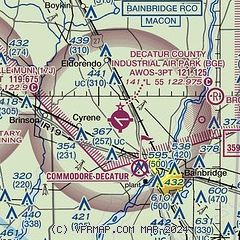
| Sectional chart |
|---|
|
| Airport distance calculator |
|---|
|
|
| Sunrise and sunset |
|---|
|
Times for 25-Apr-2025
| | Local
(UTC-4) | | Zulu
(UTC) |
|---|
| Morning civil twilight | | 06:36 | | 10:36 |
| Sunrise | | 07:01 | | 11:01 |
| Sunset | | 20:12 | | 00:12 |
| Evening civil twilight | | 20:37 | | 00:37 |
|
| Current date and time |
|---|
| Zulu (UTC) | 25-Apr-2025 06:14:26 |
|---|
| Local (UTC-4) | 25-Apr-2025 02:14:26 |
|---|
|
| METAR |
|---|
| KBGE | 250555Z AUTO 12003KT 7SM BKN040 19/ A3014 RMK AO2 T0188//// 10232 20184
|
K17J
13nm W | 250555Z AUTO 10004KT 10SM CLR 19/16 A3015 RMK AO2
|
|
| TAF |
|---|
KTLH
37nm SE | 250540Z 2506/2606 10003KT 6SM BR SCT025 BKN040 FM251300 13008KT P6SM SCT030 FM251700 17010KT P6SM SCT050 FM252300 20005KT P6SM FEW080
|
KABY
40nm NE | 250540Z 2506/2606 13004KT 4SM BR FEW050 FM251200 15007KT P6SM SCT050 FM251900 19008KT P6SM SCT040 PROB30 2600/2602 22005KT -TSRA BKN050CB
|
KDHN
47nm NW | 250540Z 2506/2606 VRB03KT P6SM SCT040 FM250900 00000KT 4SM BR SCT003 BKN015 FM251300 15006KT P6SM SCT040 FM251800 19008KT P6SM SCT040 PROB30 2522/2524 22010KT -TSRA BKN040CB
|
|
| NOTAMs |
|---|
NOTAMs are issued by the DoD/FAA and will open in a separate window not controlled by AirNav.
|
|


