FAA INFORMATION EFFECTIVE 09 JULY 2026
Location
| FAA Identifier: | BUF |
| Lat/Long: | 42-56-25.5380N 078-43-50.0510W
42-56.425633N 078-43.834183W
42.9404272,-78.7305697
(estimated) |
| Elevation: | 726.8 ft. / 221.5 m (surveyed) |
| Variation: | 11W (2015) |
| From city: | 5 miles E of BUFFALO, NY |
| Time zone: | UTC -4 (UTC -5 during Standard Time) |
| Zip code: | 14225 |
Airport Operations
| Airport use: | Open to the public |
| Activation date: | 03/1940 |
| Control tower: | yes |
| ARTCC: | CLEVELAND CENTER |
| FSS: | BUFFALO FLIGHT SERVICE STATION |
| NOTAMs facility: | BUF (NOTAM-D service available) |
| Attendance: | CONTINUOUS |
| Wind indicator: | lighted |
| Segmented circle: | no |
| Beacon: | white-green (lighted land airport)
Operates sunset to sunrise. |
| Landing fee: | yes |
| Fire and rescue: | ARFF index C |
| Airline operations: | ARFF INDEX D EQUIPMENT COVERAGE PROVIDED. |
| International operations: | customs landing rights airport |
Airport Communications
| WX ASOS: | PHONE 716-587-0517 |
| BUFFALO GROUND: | 133.2 257.8 |
| BUFFALO TOWER: | 120.5 257.8 |
| BUFFALO APPROACH: | 126.15 ;053-233 126.5 ;234-052 263.125 ;053-233 317.6 ;234-052 |
| BUFFALO DEPARTURE: | 126.15 ;053-233 126.5 ;234-052 263.125 ;053-233 317.6 ;234-052 |
| CLEARANCE DELIVERY: | 124.7 257.8 |
| PRE-TAXI CLEARANCE: | 124.7 |
| CLASS C: | 126.15 ;053-233 126.5 ;234-052 263.125 ;053-233 317.6 ;234-052 |
| D-ATIS: | 135.35 |
| EMERG: | 121.5 243.0 |
| IC: | 126.15 ;053-233 263.125 ;053-233 |
| WX ASOS at IAG (14 nm NW): | PHONE 716-409-9256 |
Nearby radio navigation aids
| NDB name | | Hdg/Dist | | Freq | | Var | | ID |
|---|
| KLUMP | | 233/5.0 | | 231 | | 09W | | BU | -... ..- |
| PLAZZ | | 052/5.5 | | 204 | | 09W | | GB | --. -... |
| KATHI | | 165/11.2 | | 329 | | 10W | | IA | .. .- |
Airport Services
| Fuel available: | 100LL JET-A |
| Parking: | hangars and tiedowns |
| Airframe service: | MAJOR |
| Powerplant service: | MAJOR |
| Bottled oxygen: | HIGH/LOW |
| Bulk oxygen: | HIGH/LOW |
Runway Information
Runway 5/23
| Dimensions: | 8829 x 150 ft. / 2691 x 46 m |
| Surface: | asphalt/grooved, in good condition |
| Weight bearing capacity: | | Single wheel: | 120.0 | | Double wheel: | 250.0 | | Double tandem: | 550.0 | | Dual double tandem: | 1120.0 |
|
| Runway edge lights: | high intensity |
| RUNWAY 5 | | RUNWAY 23 |
| Latitude: | 42-55.871977N | | 42-56.918410N |
| Longitude: | 078-44.501083W | | 078-43.128460W |
| Elevation: | 674.1 ft. | | 726.8 ft. |
| Traffic pattern: | left | | left |
| Runway heading: | 055 magnetic, 044 true | | 235 magnetic, 224 true |
| Displaced threshold: | 535 ft. | | 725 ft. |
| Declared distances: | TORA:8829 TODA:8829 ASDA:8104 LDA:7569 | | TORA:8829 TODA:8829 ASDA:8294 LDA:7569 |
| Markings: | precision, in good condition | | precision, in good condition |
| Visual slope indicator: | 4-light PAPI on left (3.00 degrees glide path) | | 4-light PAPI on right (3.00 degrees glide path) |
| RVR equipment: | touchdown, midfield, rollout | | touchdown, midfield, rollout |
| Approach lights: | MALSR: 1,400 foot medium intensity approach lighting system with runway alignment indicator lights | | ALSF2: standard 2,400 foot high intensity approach lighting system with centerline sequenced flashers (category II or III) |
| Centerline lights: | yes | | yes |
| Touchdown point: | yes, lighted | | yes, lighted |
| Instrument approach: | ILS | | ILS |
| Obstructions: | 21 ft. bldg, 413 ft. from runway, 532 ft. right of centerline, 10:1 slope to clear
RWY 05 HAS +3 FT POLE LIGHT POLE 59 FT FM RWY END, 497 FT RIGHT. | | 29 ft. tree, 1155 ft. from runway, 360 ft. right of centerline, 32:1 slope to clear |
Runway 14/32
| Dimensions: | 7161 x 150 ft. / 2183 x 46 m |
| Surface: | asphalt/grooved, in good condition |
| Weight bearing capacity: | | Single wheel: | 120.0 | | Double wheel: | 250.0 | | Double tandem: | 489.0 | | Dual double tandem: | 1016.0 |
|
| Runway edge lights: | high intensity |
| RUNWAY 14 | | RUNWAY 32 |
| Latitude: | 42-56.815040N | | 42-56.111127N |
| Longitude: | 078-44.501610W | | 078-43.214502W |
| Elevation: | 699.1 ft. | | 708.8 ft. |
| Traffic pattern: | left | | left |
| Runway heading: | 138 magnetic, 127 true | | 318 magnetic, 307 true |
| Displaced threshold: | 320 ft. | | 720 ft. |
| Declared distances: | TORA:7161 TODA:7161 ASDA:6441 LDA:6121 | | TORA:7161 TODA:7161 ASDA:6841 LDA:6121 |
| Markings: | nonprecision, in good condition | | precision, in good condition |
| Visual slope indicator: | 4-light PAPI on left (3.00 degrees glide path) | | 4-light PAPI on left (3.00 degrees glide path) |
| Approach lights: | | | MALSR: 1,400 foot medium intensity approach lighting system with runway alignment indicator lights |
| Runway end identifier lights: | yes | | no |
| Touchdown point: | yes, no lights | | yes, no lights |
| Instrument approach: | | | ILS/DME |
| Obstructions: | 31 ft. tree, 608 ft. from runway, 535 ft. right of centerline, 13:1 slope to clear
RWY 14 APCH SLOPE 29:1 TO DSPLCD THLD. | | 14 ft. sign, 200 ft. from runway, 429 ft. left of centerline, 1:1 slope to clear
+7 FT OBSTRUCTION LIGHTED FENCE , 0 FT FM RWY END, 480 FT LEFT. |
Airport Ownership and Management from official FAA records
| Ownership: | Publicly-owned |
| Owner: | NIAGARA FRONTIER TRAN AUTH
181 ELLICOTT ST, PO BOX 5008
BUFFALO, NY 14205
Phone 716-855-7300 |
| Manager: | LEE WEITZ
4200 GENESEE ST
BUFFALO, NY 14225
Phone (716) 630-6030 |
Additional Remarks
| A39-05/23 | PCR VALUE: 2110/F/B/X/T |
| A39-14/32 | PCR VALUE: 900/F/D/X/T |
| - | HEAVY CONCENTRATION OF GULLS; BLACKBIRDS & STARLINGS UP TO 5000 FT ON & INVOF ARPT. |
| - | DEER ON & INVOF ARPT. |
| - | FOR FBO SVCS CTC 131.75; FOR CARGO SVCS CTC 122.95. |
| - | TWY A SW RUNUP AREA/HLDG BAY MKD DESIGN GROUP 3 ACFT (GENERALLY B737 A321 OR SMALLER) UNAVBL DESIGN GROUP 4 (INCL BUT NOT LTD TO B757 767). |
| - | TWY 'K1' CLSD 2100-0800 DAILY. |
| - | TWY P BTN APCH END RWY 14 AND TWY P2 CLSD TO ACFT WINGSPAN MORE THAN 117 FT. |
Instrument Procedures
NOTE: All procedures below are presented as PDF files. If you need a reader for these files, you should download the free Adobe Reader.NOT FOR NAVIGATION. Please procure official charts for flight.
FAA instrument procedures published for use from 09 July 2026 at 0901Z to 06 August 2026 at 0900Z.
IAPs - Instrument Approach Procedures |
|---|
| ILS OR LOC RWY 05 | |
download (230KB) |
| ILS OR LOC RWY 23 | |
download (246KB) |
| ILS OR LOC RWY 32 | |
download (249KB) |
| ILS RWY 23 (SA CAT I) | |
download (227KB) |
| RNAV (RNP) Z RWY 05 | |
download (239KB) |
| RNAV (RNP) Z RWY 23 | |
download (265KB) |
| RNAV (GPS) RWY 14 | |
download (207KB) |
| RNAV (GPS) RWY 32 | |
download (247KB) |
| RNAV (GPS) Y RWY 05 | |
download (221KB) |
| RNAV (GPS) Y RWY 23 | |
download (220KB) |
Departure Procedures |
|---|
| BUFFALO EIGHT | |
download (186KB) |
| NOTE: Special Take-Off Minimums/Departure Procedures apply | |
download (463KB) |
Other nearby airports with instrument procedures:
9G0 - Buffalo Airfield (5 nm S)
KBQR - Buffalo-Lancaster Regional Airport (5 nm E)
9G3 - Akron Airport/Jesson Field (12 nm NE)
KIAG - Niagara Falls International Airport (14 nm NW)
9G6 - Pine Hill Airport (24 nm NE)
|
|

Road maps at:
MapQuest
Bing
Google
| Aerial photo |
|---|
WARNING: Photo may not be current or correct
 Photo by David Newcomer
Photo taken 24-Apr-2016
looking north from 5,000 MSL.
Photo by David Newcomer
Photo taken 24-Apr-2016
looking north from 5,000 MSL.
Do you have a better or more recent aerial photo of Buffalo Niagara International Airport that you would like to share? If so, please send us your photo.
|
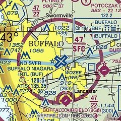
| Sectional chart |
|---|
|
CAUTION: Diagram may not be current
 Download PDF
of official airport diagram from the FAA
| Airport distance calculator |
|---|
|
|
| Sunrise and sunset |
|---|
|
Times for 26-Jul-2026
| | Local
(UTC-4) | | Zulu
(UTC) |
|---|
| Morning civil twilight | | 05:28 | | 09:28 |
| Sunrise | | 06:01 | | 10:01 |
| Sunset | | 20:42 | | 00:42 |
| Evening civil twilight | | 21:15 | | 01:15 |
|
| Current date and time |
|---|
| Zulu (UTC) | 27-Jul-2026 03:10:56 |
|---|
| Local (UTC-4) | 26-Jul-2026 23:10:56 |
|---|
|
| METAR |
|---|
| KBUF | 270254Z 20005KT 10SM SCT065 BKN110 22/17 A2987 RMK AO2 SLP111 T02170172 53005 $
|
KIAG
14nm NW | 270253Z 21004KT 10SM BKN065 BKN110 21/19 A2985 RMK AO2 SLP103 T02110189 53003
|
|
| TAF |
|---|
| KBUF | 261720Z 2618/2718 24008KT P6SM SCT040 BKN090 FM262300 25006KT P6SM SCT100 FM270400 VRB03KT P6SM SCT050 FM271300 24006KT P6SM SCT200
|
KIAG
14nm NW | 261720Z 2618/2718 26008KT P6SM SCT040 BKN090 FM262200 24008KT P6SM SCT100 FM270200 VRB03KT P6SM SCT250 TEMPO 2707/2711 5SM BR FM271200 23006KT P6SM SCT200
|
|
| NOTAMs |
|---|
NOTAMs are issued by the DoD/FAA and will open in a separate window not controlled by AirNav.
|
|


