FAA INFORMATION EFFECTIVE 16 APRIL 2026
Location
| FAA Identifier: | BQR |
| Lat/Long: | 42-55-19.4000N 078-36-43.1000W
42-55.323333N 078-36.718333W
42.9220556,-78.6119722
(estimated) |
| Elevation: | 751.7 ft. / 229.1 m (surveyed) |
| Variation: | 10W (1985) |
| From city: | 12 miles E of BUFFALO, NY |
| Time zone: | UTC -4 (UTC -5 during Standard Time) |
| Zip code: | 14086 |
Airport Operations
| Airport use: | Open to the public |
| Activation date: | 02/1969 |
| Control tower: | no |
| ARTCC: | CLEVELAND CENTER |
| FSS: | BUFFALO FLIGHT SERVICE STATION |
| NOTAMs facility: | BUF (NOTAM-D service available) |
| Attendance: | ON CALL
716-860-6044. |
| Pattern altitude: | 1551.7 ft. MSL |
| Wind indicator: | lighted |
| Segmented circle: | no |
| Lights: | ACTVT REILS RWY 09 & 27; PAPIS RWY 09 & 27; MIRLS RWY 9/27 - CTAF. |
| Beacon: | white-green (lighted land airport)
Operates sunset to sunrise. |
Airport Communications
| CTAF/UNICOM: | 123.05 |
| BUFFALO APPROACH: | 126.15 |
| BUFFALO DEPARTURE: | 126.15 |
| WX ASOS at BUF (5 nm W): | PHONE 716-587-0517 |
| WX ASOS at IAG (18 nm NW): | PHONE 716-409-9256 |
- AUTOMATED UNICOM. ADZY ALSO AVBL BY CALLING 617-262-3825.
Nearby radio navigation aids
| VOR radial/distance | | VOR name | | Freq | | Var |
|---|
| GEEr287/39.0 | | GENESEO VOR/DME | | 108.20 | | 09W |
| NDB name | | Hdg/Dist | | Freq | | Var | | ID |
|---|
| KLUMP | | 169/5.0 | | 231 | | 09W | | BU | -... ..- |
| PLAZZ | | 081/9.4 | | 204 | | 09W | | GB | --. -... |
| KATHI | | 149/15.0 | | 329 | | 10W | | IA | .. .- |
Airport Services
| Fuel available: | 100LL |
| Parking: | hangars and tiedowns |
| Airframe service: | MAJOR |
| Powerplant service: | MAJOR |
| Bottled oxygen: | NONE |
| Bulk oxygen: | NONE |
Runway Information
Runway 9/27
| Dimensions: | 3199 x 75 ft. / 975 x 23 m |
| Surface: | asphalt, in fair condition |
| Runway edge lights: | medium intensity |
| RUNWAY 9 | | RUNWAY 27 |
| Latitude: | 42-55.262767N | | 42-55.382658N |
| Longitude: | 078-37.066650W | | 078-36.368970W |
| Elevation: | 751.6 ft. | | 750.5 ft. |
| Traffic pattern: | left | | left |
| Markings: | nonprecision, in fair condition | | nonprecision, in fair condition |
| Visual slope indicator: | 2-light PAPI on right (3.00 degrees glide path)
RWY 09 PAPI UNUSBL BYD 3 DEG RT OF RCL. | | 2-light PAPI on left (3.00 degrees glide path)
RWY 27 PAPI UNUSBL BYD 5 DEG LEFT OF RCL. |
| Runway end identifier lights: | yes | | yes |
| Touchdown point: | yes, no lights | | yes, no lights |
| Obstructions: | 23 ft. rr, marked and lighted, 201 ft. from runway, 215 ft. right of centerline
9 FT FENCE, 15 FT TREE, 23 FT RR. | | 25 ft. rr, 201 ft. from runway, 215 ft. left of centerline
9 FT FENCE, 25 FT RR. |
Airport Ownership and Management from official FAA records
| Ownership: | Privately-owned |
| Owner: | LANCASTER APT INC (THOMAS GELES)
4343 WALDEN AVE
LANCASTER, NY 14086
Phone 585-591-0366 |
| Manager: | GEORGE EZZO
DARIEN CENTER, NY 14040-1922
Phone 716-860-6044
ALTN CTC: ERIC WOBSCHALL 716-208-5460 ERIC@BUFFALOLANCASTER.COM. |
Additional Remarks
| - | 25 FT RLRD; 215 FT S & PARL TO RWY. |
| - | FOR CD CTC CLEVELAND ARTCC AT 440-774-0490. |
Instrument Procedures
NOTE: All procedures below are presented as PDF files. If you need a reader for these files, you should download the free Adobe Reader.NOT FOR NAVIGATION. Please procure official charts for flight.
FAA instrument procedures published for use from 16 April 2026 at 0901Z to 14 May 2026 at 0900Z.
IAPs - Instrument Approach Procedures |
|---|
| RNAV (GPS) RWY 09 | |
download (188KB) |
| RNAV (GPS) RWY 27 | |
download (190KB) |
| NOTE: Special Take-Off Minimums/Departure Procedures apply | |
download (459KB) |
Other nearby airports with instrument procedures:
KBUF - Buffalo Niagara International Airport (5 nm W)
9G0 - Buffalo Airfield (6 nm SW)
9G3 - Akron Airport/Jesson Field (8 nm NE)
KIAG - Niagara Falls International Airport (18 nm NW)
KGVQ - Genesee County Airport (21 nm E)
|
|

Road maps at:
MapQuest
Bing
Google
| Aerial photo |
|---|
WARNING: Photo may not be current or correct
 Photo by David Newcomer
Photo taken 26-Apr-2016
looking north from 2,000 MSL.
Photo by David Newcomer
Photo taken 26-Apr-2016
looking north from 2,000 MSL.
Do you have a better or more recent aerial photo of Buffalo-Lancaster Regional Airport that you would like to share? If so, please send us your photo.
|
| Sectional chart |
|---|
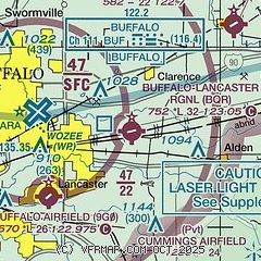
|
| Airport distance calculator |
|---|
|
|
| Sunrise and sunset |
|---|
|
Times for 07-May-2026
| | Local
(UTC-4) | | Zulu
(UTC) |
|---|
| Morning civil twilight | | 05:30 | | 09:30 |
| Sunrise | | 06:02 | | 10:02 |
| Sunset | | 20:21 | | 00:21 |
| Evening civil twilight | | 20:52 | | 00:52 |
|
| Current date and time |
|---|
| Zulu (UTC) | 07-May-2026 08:27:09 |
|---|
| Local (UTC-4) | 07-May-2026 04:27:09 |
|---|
|
| METAR |
|---|
KBUF
5nm W | 070754Z 20003KT OVC060 04/04 A2989 RMK AO2 SLP124 T00440039 $
|
KIAG
18nm NW | 070753Z AUTO 36005KT 6SM BR SCT060 SCT075 04/03 A2989 RMK AO2 SLP129 T00390033 $
|
|
| TAF |
|---|
KBUF
5nm W | 070520Z 0706/0806 22004KT P6SM SCT070 BKN120 FM071400 25007KT P6SM SCT090 FM071800 25011KT P6SM VCSH BKN060 FM072300 25007KT 6SM -SHRA OVC040 FM080300 25006KT P6SM BKN050
|
KIAG
18nm NW | 070520Z 0706/0806 23005KT P6SM SCT070 BKN120 FM071400 26007KT P6SM SCT060 FM071800 26011KT 6SM -SHRA BKN040 FM072100 25009KT 5SM -SHRA OVC040 FM080200 26006KT P6SM BKN050
|
|
| NOTAMs |
|---|
NOTAMs are issued by the DoD/FAA and will open in a separate window not controlled by AirNav.
|
|

