FAA INFORMATION EFFECTIVE 15 MAY 2025
Location
| FAA Identifier: | D79 |
| Lat/Long: | 42-16-05.2080N 079-28-54.1680W
42-16.086800N 079-28.902800W
42.2681133,-79.4817133
(estimated) |
| Elevation: | 1330 ft. / 405 m (estimated) |
| Variation: | 09W (1985) |
| From city: | 2 miles E of MAYVILLE, NY |
| Time zone: | UTC -4 (UTC -5 during Standard Time) |
| Zip code: | 14757 |
Airport Operations
| Airport use: | Open to the public |
| Activation date: | 09/1971 |
| Control tower: | no |
| ARTCC: | CLEVELAND CENTER |
| FSS: | BUFFALO FLIGHT SERVICE STATION |
| NOTAMs facility: | BUF (NOTAM-D service available) |
| Attendance: | DAYLIGHT HOURS |
| Pattern altitude: | 2130 ft. MSL |
| Wind indicator: | yes |
| Segmented circle: | no |
Airport Communications
| CTAF: | 122.9 |
| WX AWOS-3PT at JHW (12 nm SE): | 118.425 (716-664-6005) |
| WX ASOS at DKK (16 nm NE): | 119.275 (716-366-7664) |
Nearby radio navigation aids
| VOR radial/distance | | VOR name | | Freq | | Var |
|---|
| JHWr294/16.7 | | JAMESTOWN VOR/DME | | 114.70 | | 07W |
Airport Services
| Airframe service: | NONE |
| Powerplant service: | NONE |
| Bottled oxygen: | NONE |
| Bulk oxygen: | NONE |
Runway Information
Runway 10/28
| Dimensions: | 3800 x 60 ft. / 1158 x 18 m |
| Surface: | turf, in good condition |
| RUNWAY 10 | | RUNWAY 28 |
| Traffic pattern: | left | | left |
| Obstructions: | 50 ft. trees, 185 ft. from runway, 90 ft. left of centerline, 3:1 slope to clear | | 19 ft. hangar, 53 ft. from runway, 73 ft. left of centerline, 2:1 slope to clear |
Runway 13/31
| Dimensions: | 2750 x 60 ft. / 838 x 18 m |
| Surface: | turf, in good condition |
| RUNWAY 13 | | RUNWAY 31 |
| Traffic pattern: | left | | left |
| Obstructions: | 40 ft. pline, 1 ft. from runway, 83 ft. left of centerline
CTLNG OBSTN EXCEEDS 45 DEG SLP. | | 40 ft. pole, 32 ft. from runway, 31 ft. right of centerline |
Runway 6/24
| Dimensions: | 1840 x 80 ft. / 561 x 24 m |
| Surface: | turf, in good condition |
| RUNWAY 6 | | RUNWAY 24 |
| Traffic pattern: | left | | left |
| Obstructions: | 70 ft. trees, 106 ft. left of centerline
CTLNG OBSTN EXCEEDS 45 DEG SLP. | | 40 ft. tree, 99 ft. left of centerline |
Airport Ownership and Management from official FAA records
| Ownership: | Privately-owned |
| Owner: | GREGORY G. DART
PO BOX 211
MAYVILLE, NY 14757
Phone 716-753-2160 |
| Manager: | GREGORY G. DART
6167 PLANK RD
MAYVILLE, NY 14757
Phone 716-753-6711 |
Additional Remarks
| - | EXTSV GLIDER OPNS ON & INVOF ARPT. |
| - | ULTRALIGHT ACTIVITY ON & INVOF ARPT. |
| - | FOR CD CTC BUFFALO APCH AT 716-626-6920, WHEN APCH CLSD CTC CLEVELAND ARTCC AT 440-774-0232. |
Instrument Procedures
There are no published instrument procedures at D79.
Some nearby airports with instrument procedures:
KJHW - Chautauqua County/Jamestown Airport (12 nm SE)
KDKK - Chautauqua County/Dunkirk Airport (16 nm NE)
8G2 - Corry-Lawrence Airport (23 nm S)
KERI - Erie International Airport/Tom Ridge Field (33 nm W)
6G1 - Titusville Airport (41 nm S)
|
|

Road maps at:
MapQuest
Bing
Google
| Aerial photo |
|---|
WARNING: Photo may not be current or correct
 Photo by David Cooney
Photo taken 29-May-2006
Photo by David Cooney
Photo taken 29-May-2006
Do you have a better or more recent aerial photo of Dart Airport that you would like to share? If so, please send us your photo.
|
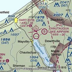
| Sectional chart |
|---|
|
| Airport distance calculator |
|---|
|
|
| Sunrise and sunset |
|---|
|
Times for 08-Jun-2025
| | Local
(UTC-4) | | Zulu
(UTC) |
|---|
| Morning civil twilight | | 05:08 | | 09:08 |
| Sunrise | | 05:42 | | 09:42 |
| Sunset | | 20:51 | | 00:51 |
| Evening civil twilight | | 21:26 | | 01:26 |
|
| Current date and time |
|---|
| Zulu (UTC) | 08-Jun-2025 09:44:50 |
|---|
| Local (UTC-4) | 08-Jun-2025 05:44:50 |
|---|
|
| METAR |
|---|
KJHW
13nm SE | 080856Z AUTO 09004KT 10SM CLR 14/09 A2984 RMK AO2 SLP103 6//// T01390094 56015 PNO $
|
KDKK
16nm NE | 080853Z AUTO 00000KT 9SM CLR 11/10 A2981 RMK AO2 SLPNO T01110100 56017 $
|
|
| TAF |
|---|
KJHW
13nm SE | 080527Z 0806/0906 06005KT P6SM BKN250 FM081000 10007KT P6SM BKN250 FM081500 13009KT P6SM BKN200 PROB30 0818/0820 4SM -TSRA OVC025CB FM082000 15008KT P6SM OVC035 PROB30 0820/0902 4SM -TSRA OVC025CB FM090200 14007KT P6SM BKN015 PROB30 0903/0906 4SM -SHRA OVC008
|
|
| NOTAMs |
|---|
NOTAMs are issued by the DoD/FAA and will open in a separate window not controlled by AirNav.
|
|


