FAA INFORMATION EFFECTIVE 14 MAY 2026
Location
| FAA Identifier: | ERI |
| Lat/Long: | 42-04-59.1000N 080-10-26.2000W
42-04.985000N 080-10.436667W
42.0830833,-80.1739444
(estimated) |
| Elevation: | 732.1 ft. / 223.1 m (surveyed) |
| Variation: | 10W (2015) |
| From city: | 5 miles SW of ERIE, PA |
| Time zone: | UTC -4 (UTC -5 during Standard Time) |
| Zip code: | 16505 |
Airport Operations
| Airport use: | Open to the public |
| Activation date: | 05/1938 |
| Control tower: | yes |
| ARTCC: | CLEVELAND CENTER |
| FSS: | ALTOONA FLIGHT SERVICE STATION |
| NOTAMs facility: | ERI (NOTAM-D service available) |
| Attendance: | MON-FRI 0500-2300, ALL SAT-SUN 0500-2200 |
| Wind indicator: | lighted |
| Segmented circle: | yes |
| Lights: | WHEN ATCT CLSD ACTVT MALSR RY 06/24; PAPI RY 06/24; HIRL RY 06/24; VASI RY 20; MIRL RY 02/20 & TWY LGTS - CTAF. |
| Beacon: | white-green (lighted land airport)
Operates sunset to sunrise. |
| Landing fee: | yes |
| Fire and rescue: | ARFF index B |
| International operations: | customs landing rights airport
RAMP USAGE FEE FOR ACFT CLEARING CUSTOMS. FEE BASED ON
ACFT WGT, CTC ARPT FOR FEE SKED. |
Airport Communications
| CTAF: | 118.1 |
| UNICOM: | 122.95 |
| ATIS: | 120.35 |
| WX ASOS: | 120.35 (724-252-2105) |
| ERIE GROUND: | 121.9 [0600-0000] |
| ERIE TOWER: | 118.1 257.8 [0600-0000] |
| BUFFALO APPROACH: | 121.0 |
| BUFFALO DEPARTURE: | 121.0 |
| CLEARANCE DELIVERY: | 126.8 |
| EMERG: | 121.5 243.0 |
| TRSA: | 121.0 257.8 |
- APCH/DEP SVC PRVDD BY BUFFALO APCH (BUF) ON FREQS 121.0/257.8 0600-0000. APCH/DEP SVC PRVDD BY CLEVELAND ARTCC (ZOB) ON FREQS 127.075/292.175 (WATERFORD RCAG) 0000-0600.
Airport Services
| Fuel available: | 100LL JET-A |
| Parking: | hangars and tiedowns |
| Airframe service: | MINOR |
| Powerplant service: | MINOR |
| Bottled oxygen: | HIGH/LOW |
| Bulk oxygen: | NONE |
Runway Information
Runway 6/24
| Dimensions: | 8420 x 150 ft. / 2566 x 46 m |
| Surface: | asphalt/grooved, in good condition |
| Weight bearing capacity: | | Single wheel: | 114.0 | | Double wheel: | 161.0 | | Double tandem: | 264.0 |
|
| Runway edge lights: | high intensity |
| RUNWAY 6 | | RUNWAY 24 |
| Latitude: | 42-04.599060N | | 42-05.404307N |
| Longitude: | 080-11.063857W | | 080-09.549113W |
| Elevation: | 731.7 ft. | | 723.5 ft. |
| Traffic pattern: | left | | left |
| Runway heading: | 064 magnetic, 054 true | | 244 magnetic, 234 true |
| Displaced threshold: | 919 ft. | | no |
| Declared distances: | TORA:8420 TODA:8420 ASDA:8420 LDA:7501 | | TORA:8420 TODA:8420 ASDA:7500 LDA:7500 |
| Markings: | precision, in good condition | | precision, in good condition |
| Visual slope indicator: | 4-light PAPI on left (3.00 degrees glide path) | | 4-light PAPI on left (3.00 degrees glide path) |
| RVR equipment: | touchdown, rollout | | touchdown, rollout |
| Approach lights: | MALSR: 1,400 foot medium intensity approach lighting system with runway alignment indicator lights
MALSR UNMON. | | MALSR: 1,400 foot medium intensity approach lighting system with runway alignment indicator lights
MALSR UNMON. |
| Touchdown point: | yes, no lights | | yes, no lights |
| Instrument approach: | ILS/DME | | ILS/DME |
| Obstructions: | 31 ft. rr, lighted, 202 ft. from runway, 360 ft. right of centerline
+21 FT OBST LGTD POLE AT 8 FT FROM AER 325 FT R, +15 FT BILLBOARD AT 189 FT FROM AER 327 FT R. | | 105 ft. trees, 1544 ft. from runway, 698 ft. right of centerline, 12:1 slope to clear |
Runway 2/20
| Dimensions: | 3508 x 150 ft. / 1069 x 46 m |
| Surface: | asphalt, in fair condition |
| Weight bearing capacity: | | Single wheel: | 50.0 | | Double wheel: | 60.0 | | Double tandem: | 150.0 |
|
| Runway edge lights: | medium intensity |
| Operational restrictions: | RWY 02/20 NOT AVBL FOR PART 121/PART 380 OPS WITH SKED PAX CARRYING OPS MORE THAN 9 PAX SEATS AND NON-SKED PAX CARRYING OPS MORE THAN 30 PAX SEATS. |
| RUNWAY 2 | | RUNWAY 20 |
| Latitude: | 42-04.658215N | | 42-05.226810N |
| Longitude: | 080-10.814290W | | 080-10.678103W |
| Elevation: | 731.4 ft. | | 727.3 ft. |
| Traffic pattern: | left | | left |
| Runway heading: | 020 magnetic, 010 true | | 200 magnetic, 190 true |
| Displaced threshold: | 817 ft. | | 306 ft. |
| Declared distances: | TORA:3508 TODA:3508 ASDA:3337 LDA:2520 | | TORA:3508 TODA:3508 ASDA:3208 LDA:2902 |
| Markings: | nonprecision, in good condition | | nonprecision, in good condition |
| Visual slope indicator: | | | 4-box VASI on left (4.00 degrees glide path) |
| Touchdown point: | yes, no lights | | yes, no lights |
| Obstructions: | 31 ft. rr, lighted, 200 ft. from runway
+31 FT RR ANGLES ACROSS RWY CL +32 FT OBST LGTD POLE 106 FT FM AER 17 FT RT. | | 17 ft. road, 200 ft. from runway
+15 FT ROAD AT AER 225 FT R. +9 FT FENCE 65 FT FM RWY END 128 FT R. |
Airport Ownership and Management from official FAA records
| Ownership: | Publicly-owned |
| Owner: | ERIE REGIONAL ARPT AUTHORITY
4411 W 12TH ST
ERIE, PA 16505
Phone 814-833-4258 |
| Manager: | DEREK MARTIN
4411 W 12TH ST
ERIE, PA 16505
Phone 814-833-4258 |
Additional Remarks
| A39-06/24 | PCR VALUE: 670/F/D/X/T |
| - | BIRDS ON & INVOF ARPT. |
| - | EXTENSIVE NON-RADIO & ULTRALGT ACFT OPR 3.5-5 NM SOUTHWEST OF ARPT AT OR BLO 700 FT AGL MAY 1-OCT 31 ANNUALLY SR-SS. |
| - | FLIGHT NOTIFICATION SERVICE (ADCUS) AVAILABLE; PRIOR RESERVATION REQUIRED; PHONE 814-833-1355. |
| - | FOR CD CTC BUFFALO APCH AT 716-626-6920, WHEN APCH CLSD CTC CLEVELAND ARTCC AT 440-774-0232. |
| - | INDEX C AVAIL UPON REQUEST |
Instrument Procedures
NOTE: All procedures below are presented as PDF files. If you need a reader for these files, you should download the free Adobe Reader.NOT FOR NAVIGATION. Please procure official charts for flight.
FAA instrument procedures published for use from 14 May 2026 at 0901Z to 11 June 2026 at 0900Z.
IAPs - Instrument Approach Procedures |
|---|
| ILS OR LOC RWY 06 **CHANGED** | |
download (227KB) |
| ILS OR LOC RWY 24 **CHANGED** | |
download (203KB) |
| RNAV (GPS) RWY 06 **CHANGED** | |
download (234KB) |
| RNAV (GPS) RWY 24 **CHANGED** | |
download (239KB) |
| NOTE: Special Alternate Minimums apply | |
download (123KB) |
| NOTE: Special Take-Off Minimums/Departure Procedures apply | |
download (427KB) |
Other nearby airports with instrument procedures:
8G2 - Corry-Lawrence Airport (26 nm SE)
KGKJ - Port Meadville Airport (27 nm S)
KHZY - Northeast Ohio Regional Airport (30 nm SW)
6G1 - Titusville Airport (34 nm SE)
4G1 - Greenville Municipal Airport (39 nm S)
|
|

Road maps at:
MapQuest
Bing
Google
| Aerial photo |
|---|
WARNING: Photo may not be current or correct
 Photo taken 25-Sep-2016
looking northwest.
Photo taken 25-Sep-2016
looking northwest.
Do you have a better or more recent aerial photo of Erie International Airport/Tom Ridge Field that you would like to share? If so, please send us your photo.
|
| Sectional chart |
|---|
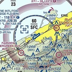
|
 Download PDF
of official airport diagram from the FAA
| Airport distance calculator |
|---|
|
|
| Sunrise and sunset |
|---|
|
Times for 18-May-2026
| | Local
(UTC-4) | | Zulu
(UTC) |
|---|
| Morning civil twilight | | 05:26 | | 09:26 |
| Sunrise | | 05:58 | | 09:58 |
| Sunset | | 20:36 | | 00:36 |
| Evening civil twilight | | 21:09 | | 01:09 |
|
| Current date and time |
|---|
| Zulu (UTC) | 18-May-2026 16:30:04 |
|---|
| Local (UTC-4) | 18-May-2026 12:30:04 |
|---|
|
| METAR |
|---|
| KERI | 181551Z 20014G20KT 10SM CLR 29/17 A3007 RMK AO2 SLP175 T02940172 $
|
|
| TAF |
|---|
| KERI | 181120Z 1812/1912 19011KT P6SM SKC FM181600 21013G24KT P6SM FEW050 FM190000 20010KT P6SM BKN100
|
|
| NOTAMs |
|---|
NOTAMs are issued by the DoD/FAA and will open in a separate window not controlled by AirNav.
|
|


