FAA INFORMATION EFFECTIVE 17 APRIL 2025
Location
| FAA Identifier: | DCY |
| Lat/Long: | 38-42-02.7580N 087-07-52.6450W
38-42.045967N 087-07.877417W
38.7007661,-87.1312903
(estimated) |
| Elevation: | 472.3 ft. / 144 m (estimated) |
| Variation: | 03W (2005) |
| From city: | 3 miles NE of WASHINGTON, IN |
| Time zone: | UTC -4 (UTC -5 during Standard Time) |
| Zip code: | 47501 |
Airport Operations
| Airport use: | Open to the public |
| Activation date: | 01/1965 |
| Control tower: | no |
| ARTCC: | INDIANAPOLIS CENTER |
| FSS: | TERRE HAUTE FLIGHT SERVICE STATION |
| NOTAMs facility: | HUF (NOTAM-D service available) |
| Attendance: | MON-FRI 0800-1700 |
| Wind indicator: | lighted |
| Segmented circle: | yes |
| Lights: | ACTVT REIL RWY 18 & 36; PAPI RWY 18 & 36; MIRL RWY 18/36 - CTAF. |
| Beacon: | white-green (lighted land airport)
Operates sunset to sunrise. |
Airport Communications
| CTAF/UNICOM: | 122.8 |
| WX AWOS-3PT: | 119.075 (812-257-8889) |
| EVANSVILLE APPROACH: | 125.6 |
| EVANSVILLE DEPARTURE: | 125.6 |
- APCH/DEP SVC PRVDD BY INDIANAPOLIS ARTCC ON FREQS 128.3/291.625 (EVANSVILLE RCAG) WHEN EVANSVILLE APCH CTL CLSD.
Nearby radio navigation aids
| VOR radial/distance | | VOR name | | Freq | | Var |
|---|
| OOMr224/35.9 | | HOOSIER VORTAC | | 110.20 | | 02W |
Airport Services
| Fuel available: | 100LL JET-A+ |
| Parking: | hangars and tiedowns |
| Bottled oxygen: | LOW |
Runway Information
Runway 18/36
| Dimensions: | 5001 x 75 ft. / 1524 x 23 m |
| Surface: | asphalt/grooved, in good condition |
| Weight bearing capacity: | | Single wheel: | 10.0 | | Double wheel: | 44.0 |
|
| Runway edge lights: | medium intensity |
| RUNWAY 18 | | RUNWAY 36 |
| Latitude: | 38-42.468758N | | 38-41.644853N |
| Longitude: | 087-07.783682W | | 087-07.783585W |
| Elevation: | 456.7 ft. | | 467.4 ft. |
| Traffic pattern: | left | | left |
| Runway heading: | 183 magnetic, 180 true | | 003 magnetic, 360 true |
| Markings: | nonprecision, in fair condition | | nonprecision, in fair condition |
| Visual slope indicator: | 2-light PAPI on left (3.00 degrees glide path) | | 2-light PAPI on left (3.00 degrees glide path) |
| Runway end identifier lights: | yes | | yes |
| Touchdown point: | yes, no lights | | yes, no lights |
| Obstructions: | 10 ft. crops, 300 ft. from runway, 10:1 slope to clear
APCH SLOPE 20:1 FM DTHR. | | 10 ft. crops, 201 ft. from runway
10 FT CROPS 70 FT FM RWY END 75 FT L & R. |
Runway 9/27
| Dimensions: | 2651 x 150 ft. / 808 x 46 m |
| Surface: | turf, in fair condition |
| RUNWAY 9 | | RUNWAY 27 |
| Latitude: | 38-42.025493N | | 38-42.025500N |
| Longitude: | 087-08.333002W | | 087-07.775737W |
| Elevation: | 470.5 ft. | | 466.5 ft. |
| Traffic pattern: | left | | left |
| Runway heading: | 092 magnetic, 089 true | | 274 magnetic, 271 true |
| Displaced threshold: | no | | 403 ft. |
| Touchdown point: | yes, no lights | | yes, no lights |
| Obstructions: | 10 ft. crops, 201 ft. from runway, 20:1 slope to clear | | none |
Airport Ownership and Management from official FAA records
| Ownership: | Publicly-owned |
| Owner: | DAVIESS COUNTY BOAC
P. O. BOX 2338
WASHINGTON, IN 47501
Phone 812-698-0463 |
| Manager: | ERICA BURKEMPER
1724 E 250 N
WASHINGTON, IN 47501
Phone 812-698-0463 |
Additional Remarks
| - | FOR CD CTC EVANSVILLE APCH AT 812-436-4690, WHEN APCH CLSD CTC INDIANAPOLIS ARTCC AT 317-247-2411. |
| - | SELF SERVE FUEL AVBL. |
Instrument Procedures
NOTE: All procedures below are presented as PDF files. If you need a reader for these files, you should download the free Adobe Reader.NOT FOR NAVIGATION. Please procure official charts for flight.
FAA instrument procedures published for use from 17 April 2025 at 0901Z to 15 May 2025 at 0900z.
IAPs - Instrument Approach Procedures |
|---|
| RNAV (GPS) RWY 18 | |
download (234KB) |
| NOTE: Special Alternate Minimums apply | |
download (168KB) |
| NOTE: Special Take-Off Minimums/Departure Procedures apply | |
download (479KB) |
Other nearby airports with instrument procedures:
KLWV - Lawrenceville-Vincennes International Airport (23 nm W)
KFRH - French Lick Municipal Airport (26 nm SE)
KHNB - Huntingburg Airport (28 nm S)
KAJG - Mount Carmel Municipal Airport (28 nm W)
KSIV - Sullivan County Airport (29 nm NW)
|
|

Road maps at:
MapQuest
Bing
Google
| Aerial photo |
|---|
WARNING: Photo may not be current or correct

Do you have a better or more recent aerial photo of Daviess County Airport that you would like to share? If so, please send us your photo.
|
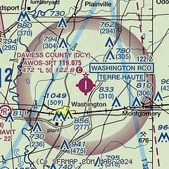
| Sectional chart |
|---|
|
| Airport distance calculator |
|---|
|
|
| Sunrise and sunset |
|---|
|
Times for 22-Apr-2025
| | Local
(UTC-4) | | Zulu
(UTC) |
|---|
| Morning civil twilight | | 06:36 | | 10:36 |
| Sunrise | | 07:04 | | 11:04 |
| Sunset | | 20:31 | | 00:31 |
| Evening civil twilight | | 20:59 | | 00:59 |
|
| Current date and time |
|---|
| Zulu (UTC) | 23-Apr-2025 00:53:12 |
|---|
| Local (UTC-4) | 22-Apr-2025 20:53:12 |
|---|
|
| METAR |
|---|
| KDCY | 230035Z AUTO 00000KT 10SM CLR 17/12 A3008 RMK AO2 T01740119
|
|
| TAF |
|---|
KHNB
28nm S | 221720Z 2218/2318 11006KT P6SM SCT250 FM230000 VRB03KT P6SM SCT250 FM231400 10006KT P6SM SCT250
|
|
| NOTAMs |
|---|
NOTAMs are issued by the DoD/FAA and will open in a separate window not controlled by AirNav.
|
|


