FAA INFORMATION EFFECTIVE 11 JUNE 2026
Location
| FAA Identifier: | DUJ |
| Lat/Long: | 41-10-41.8000N 078-53-55.3000W
41-10.696667N 078-53.921667W
41.1782778,-78.8986944
(estimated) |
| Elevation: | 1816.8 ft. / 553.8 m (surveyed) |
| Variation: | 10W (2010) |
| From city: | 7 miles NW of DUBOIS, PA |
| Time zone: | UTC -4 (UTC -5 during Standard Time) |
| Zip code: | 15851 |
Airport Operations
| Airport use: | Open to the public |
| Activation date: | 05/1960 |
| Control tower: | no |
| ARTCC: | CLEVELAND CENTER |
| FSS: | ALTOONA FLIGHT SERVICE STATION |
| NOTAMs facility: | DUJ (NOTAM-D service available) |
| Attendance: | MON-FRI 0500-0000, ALL SAT 0500-1800, ALL SUN 0800-0000 |
| Wind indicator: | lighted |
| Segmented circle: | no |
| Lights: | ACTVT HIRL RY 07/25, REIL & VASI RY 07, MALSR RY 25, & TWY LGTS - CTAF. PAPI RY 25 ON 24 HRS. |
| Beacon: | white-green (lighted land airport)
Operates sunset to sunrise. |
| Fire and rescue: | ARFF index A |
Airport Communications
| CTAF/UNICOM: | 123.0 |
| WX ASOS: | 119.025 (814-328-5140) |
- APCH/DEP SVC PRVDD BY CLEVELAND ARTCC (ZOB) ON FREQS 126.725/291.65 (DUBOIS RCAG).
Nearby radio navigation aids
| VOR radial/distance | | VOR name | | Freq | | Var |
|---|
| ETGr276/34.2 | | KEATING VORTAC | | 116.00 | | 10W |
Airport Services
| Fuel available: | 100LL JET-A |
| Parking: | tiedowns |
| Airframe service: | NONE |
| Powerplant service: | NONE |
| Bottled oxygen: | NONE |
| Bulk oxygen: | NONE |
Runway Information
Runway 7/25
| Dimensions: | 5503 x 100 ft. / 1677 x 30 m |
| Surface: | asphalt/grooved, in good condition |
| Weight bearing capacity: | | Single wheel: | 45.0 | | Double wheel: | 60.0 | | Double tandem: | 93.0 |
|
| Runway edge lights: | high intensity |
| RUNWAY 7 | | RUNWAY 25 |
| Latitude: | 41-10.486143N | | 41-10.905703N |
| Longitude: | 078-54.453250W | | 078-53.390333W |
| Elevation: | 1816.6 ft. | | 1816.8 ft. |
| Traffic pattern: | left | | left |
| Runway heading: | 072 magnetic, 062 true | | 252 magnetic, 242 true |
| Declared distances: | TORA:5503 TODA:5503 ASDA:5503 LDA:5503 | | TORA:5503 TODA:5503 ASDA:5503 LDA:5503 |
| Markings: | precision, in good condition | | precision, in good condition |
| Visual slope indicator: | 2-box VASI on left (3.00 degrees glide path) | | 4-light PAPI on left (3.00 degrees glide path)
PAPI UNUSBL BYD 8 DEG RIGHT OF RWY CNTRLN. |
| Approach lights: | | | MALSR: 1,400 foot medium intensity approach lighting system with runway alignment indicator lights |
| Runway end identifier lights: | yes | | |
| Touchdown point: | yes, no lights | | yes, no lights |
| Instrument approach: | | | ILS |
| Obstructions: | none | | 48 ft. trees, 1772 ft. from runway, 706 ft. right of centerline, 32:1 slope to clear |
Airport Ownership and Management from official FAA records
| Ownership: | Publicly-owned |
| Owner: | CLEARFIELD-JEFFERSON COUNTIES
377 AVIATION WAY
REYNOLDSVILLE, PA 15851
Phone 814-328-5311
REGIONAL AIRPORT AUTHORITY |
| Manager: | ROBERT W. SHAFFER
377 AVIATION WAY
REYNOLDSVILLE, PA 15851
Phone 814-328-5311 |
Additional Remarks
| A39-07/25 | PCR VALUE: 630/F/A/X/T |
| - | FLOCKS OF BIRDS ON & INVOF ARPT. |
| - | TPA 983 FT AGL. TPA FOR LARGE TURBINE POWERED ACFT 1483 FT AGL. |
| - | FOR CD CTC CLEVELAND ARTCC AT 440-774-0234. |
| - | ALL SFCS WIP; GRASS CUTTING APRIL THRU OCT. |
| - | RWY & TWY CONDS NOT MNT OUTSIDE OF NML ATNDNC HRS. |
Instrument Procedures
NOTE: All procedures below are presented as PDF files. If you need a reader for these files, you should download the free Adobe Reader.NOT FOR NAVIGATION. Please procure official charts for flight.
FAA instrument procedures published for use from 11 June 2026 at 0901Z to 09 July 2026 at 0900z.
IAPs - Instrument Approach Procedures |
|---|
| ILS OR LOC RWY 25 **CHANGED** | |
download (214KB) |
| RNAV (GPS) RWY 07 **CHANGED** | |
download (219KB) |
| RNAV (GPS) RWY 25 **CHANGED** | |
download (219KB) |
| NOTE: Special Alternate Minimums apply | |
download (132KB) |
| NOTE: Special Take-Off Minimums/Departure Procedures apply | |
download (149KB) |
Other nearby airports with instrument procedures:
N35 - Punxsutawney Municipal Airport (13 nm S)
KOYM - St Marys Municipal Airport (23 nm NE)
KFIG - Clearfield-Lawrence Airport (23 nm E)
KAXQ - Clarion County Airport (25 nm W)
KIDI - Indiana County Airport (Jimmy Stewart Field) (34 nm S)
|
|

Road maps at:
MapQuest
Bing
Google
| Aerial photo |
|---|
WARNING: Photo may not be current or correct
 Photo by William Pixley
Photo taken 01-Nov-2016
looking east-northeast.
Photo by William Pixley
Photo taken 01-Nov-2016
looking east-northeast.
Do you have a better or more recent aerial photo of Dubois Regional Airport that you would like to share? If so, please send us your photo.
|
| Sectional chart |
|---|
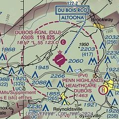
|
| Airport distance calculator |
|---|
|
|
| Sunrise and sunset |
|---|
|
Times for 12-Jun-2026
| | Local
(UTC-4) | | Zulu
(UTC) |
|---|
| Morning civil twilight | | 05:10 | | 09:10 |
| Sunrise | | 05:43 | | 09:43 |
| Sunset | | 20:48 | | 00:48 |
| Evening civil twilight | | 21:21 | | 01:21 |
|
| Current date and time |
|---|
| Zulu (UTC) | 12-Jun-2026 18:41:31 |
|---|
| Local (UTC-4) | 12-Jun-2026 14:41:31 |
|---|
|
| METAR |
|---|
| KDUJ | 121818Z AUTO 25010KT 5SM -RA BR BKN008 BKN021 OVC031 20/19 A2990 RMK AO2 RAB04 P0001 T02000194
|
|
| TAF |
|---|
| KDUJ | 121720Z 1218/1318 28010G18KT P6SM BKN040 TEMPO 1218/1219 -SHRA BKN025 FM122100 28011G19KT P6SM SCT040 BKN250 FM130100 27004KT P6SM SKC FM131500 28009KT P6SM FEW040
|
|
| NOTAMs |
|---|
NOTAMs are issued by the DoD/FAA and will open in a separate window not controlled by AirNav.
|
|

