FAA INFORMATION EFFECTIVE 14 MAY 2026
Location
| FAA Identifier: | E13 |
| Lat/Long: | 31-24-41.6650N 102-21-37.7050W
31-24.694417N 102-21.628417W
31.4115736,-102.3604736
(estimated) |
| Elevation: | 2554.7 ft. / 779 m (estimated) |
| Variation: | 09E (1985) |
| From city: | 1 mile NW of CRANE, TX |
| Time zone: | UTC -5 (UTC -6 during Standard Time) |
| Zip code: | 79731 |
Airport Operations
| Airport use: | Open to the public |
| Activation date: | 03/1943 |
| Control tower: | no |
| ARTCC: | FORT WORTH CENTER |
| FSS: | SAN ANGELO FLIGHT SERVICE STATION |
| NOTAMs facility: | SJT (NOTAM-D service available) |
| Attendance: | UNATNDD |
| Wind indicator: | lighted |
| Segmented circle: | yes |
| Lights: | PAPI RWY 12 & 30; MIRL RWY 12/30 - CTAF. |
| Beacon: | white-green (lighted land airport)
Operates sunset to sunrise. |
Airport Communications
Nearby radio navigation aids
| VOR radial/distance | | VOR name | | Freq | | Var |
|---|
| MAFr183/36.9 | | MIDLAND VORTAC | | 112.60 | | 11E |
Airport Services
Runway Information
Runway 12/30
| Dimensions: | 4258 x 70 ft. / 1298 x 21 m |
| Surface: | asphalt, in fair condition |
| Runway edge lights: | medium intensity |
| RUNWAY 12 | | RUNWAY 30 |
| Latitude: | 31-24.892500N | | 31-24.496333N |
| Longitude: | 102-21.966500W | | 102-21.290333W |
| Elevation: | 2537.9 ft. | | 2554.7 ft. |
| Traffic pattern: | left | | left |
| Displaced threshold: | no | | 488 ft. |
| Markings: | nonprecision, in good condition | | nonprecision, in good condition |
| Visual slope indicator: | 2-light PAPI on left (3.50 degrees glide path) | | 2-light PAPI on left (3.00 degrees glide path) |
| Touchdown point: | yes, no lights | | yes, no lights |
| Obstructions: | none | | 34 ft. pole, 415 ft. from runway, 57 ft. left of centerline, 6:1 slope to clear
4 FT FENCE, 0-199 FT DSTC, 28 FT L-135 FT R. |
Runway 15/33
| Dimensions: | 3395 x 50 ft. / 1035 x 15 m |
| Surface: | asphalt, in fair condition |
| RUNWAY 15 | | RUNWAY 33 |
| Traffic pattern: | left | | left |
| Displaced threshold: | no | | 176 ft. |
| Markings: | basic, in good condition | | basic, in good condition |
| Obstructions: | 20 ft. trees, 201 ft. from runway, 50 ft. left of centerline
10 FT RD, 135 FT DSTC, 125 FT L/R. 15 FT TREES 156 FT DSTC, 125 FT L/R. | | 33 ft. pline, marked and lighted, 705 ft. from runway, 185 ft. left and right of centerline, 15:1 slope to clear
APCH SLOPE 26:1 TO DSPLCD THR; TEMPORARILY 15:1 OVR 126 FT UNLGTD OIL RIG. |
Airport Ownership and Management from official FAA records
| Ownership: | Publicly-owned |
| Owner: | CRANE COUNTY
COUNTY COURTHOUSE, 201 W 6TH ST.
CRANE, TX 79731
Phone 432-558-1100 |
| Manager: | TODD SEABOURN
COUNTY COURTHOUSE, 201 W 6TH ST.
CRANE, TX 79731
Phone 432-631-5196
PARKS DEPT/AMGR. |
Additional Remarks
| - | FOR CD CTC FORT WORTH ARTCC AT 817-858-7584. |
| - | RWY 15, 75 FT PWRLINE CROSSES APCH PATH 1800 FT DSTC. |
| - | RWY 33, 126 FT UNLIGHTED TEMPORARY CRANES OCCASIONALLY IN APCH. |
Instrument Procedures
There are no published instrument procedures at E13.
Some nearby airports with instrument procedures:
E01 - Roy Hurd Memorial Airport (30 nm W)
KODO - Odessa Airport-Schlemeyer Field (31 nm N)
KMAF - Midland International Air and Space Port Airport (33 nm N)
KMDD - Midland Airpark (40 nm N)
KFST - Fort Stockton-Pecos County Airport (41 nm SW)
|
|

Road maps at:
MapQuest
Bing
Google
| Aerial photo |
|---|
WARNING: Photo may not be current or correct
 Photo by Marc Marchesseault
Photo taken 16-Oct-2008
looking north
Photo by Marc Marchesseault
Photo taken 16-Oct-2008
looking north
Do you have a better or more recent aerial photo of Crane County Airport that you would like to share? If so, please send us your photo.
|
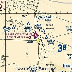
| Sectional chart |
|---|
|
| Airport distance calculator |
|---|
|
|
| Sunrise and sunset |
|---|
|
Times for 02-Jun-2026
| | Local
(UTC-5) | | Zulu
(UTC) |
|---|
| Morning civil twilight | | 06:19 | | 11:19 |
| Sunrise | | 06:46 | | 11:46 |
| Sunset | | 20:49 | | 01:49 |
| Evening civil twilight | | 21:16 | | 02:16 |
|
| Current date and time |
|---|
| Zulu (UTC) | 03-Jun-2026 04:54:30 |
|---|
| Local (UTC-5) | 02-Jun-2026 23:54:30 |
|---|
|
| METAR |
|---|
KODO
30nm N | 030353Z AUTO 12008KT 10SM CLR 27/16 A3011 RMK AO2 SLP146 T02720161
|
KMAF
33nm N | 030353Z 12009KT 10SM CLR 27/16 A3009 RMK AO2 SLP140 T02720161 $
|
KMDD
40nm N | 030435Z AUTO 14004KT 10SM CLR 27/15 A3009 RMK AO2 LTG DSNT W THRU NE T02700153
|
KFST
41nm SW | 030353Z AUTO 15007KT 10SM CLR 27/16 A3007 RMK AO2 SLP132 T02720161
|
KE41
47nm E | 030435Z AUTO 12009KT 10SM CLR 26/17 A3009 RMK AO2 LTG DSNT NE T02630172
|
KINK
48nm NW | 030253Z AUTO 14009KT CLR 30/16 A3005 RMK AO2 SLP131 T03000156 53024 TSNO $
|
|
| TAF |
|---|
KMAF
33nm N | 021721Z 0218/0318 13015G22KT P6SM SCT080 BKN250 FM030300 14011KT P6SM -SHRA BKN080 PROB30 0306/0308 VRB20G35KT -TSRA BKN050CB FM030800 08010KT P6SM -SHRA BKN080 PROB30 0308/0312 VRB20G35KT -TSRA BKN050CB
|
KFST
41nm SW | 021721Z 0218/0318 12015G22KT P6SM SCT080 BKN250 PROB30 0221/0303 VRB20G35KT -TSRA BKN050CB FM030300 11011KT P6SM BKN250
|
|
| NOTAMs |
|---|
NOTAMs are issued by the DoD/FAA and will open in a separate window not controlled by AirNav.
|
|


