FAA INFORMATION EFFECTIVE 27 NOVEMBER 2025
Location
| FAA Identifier: | EZF |
| Lat/Long: | 38-16-00.8230N 077-26-57.2650W
38-16.013717N 077-26.954417W
38.2668953,-77.4492403
(estimated) |
| Elevation: | 85 ft. / 25.9 m (surveyed) |
| Variation: | 10W (1995) |
| From city: | 2 miles S of FREDERICKSBURG, VA |
| Time zone: | UTC -5 (UTC -4 during Daylight Saving Time) |
| Zip code: | 22408 |
Airport Operations
| Airport use: | Open to the public |
| Activation date: | 09/1950 |
| Control tower: | no |
| ARTCC: | WASHINGTON CENTER |
| FSS: | LEESBURG FLIGHT SERVICE STATION |
| NOTAMs facility: | EZF (NOTAM-D service available) |
| Attendance: | 0800-1700
UNATNDD NEW YEAR'S, EASTER, INDEPENDENCE, THANKSGIVING, & CHRISTMAS DAYS. |
| Wind indicator: | lighted |
| Segmented circle: | no |
| Lights: | ACTVT MIRL RWY 06/24 - CTAF. |
| Beacon: | white-green (lighted land airport)
Operates sunset to sunrise. |
Airport Communications
| CTAF/UNICOM: | 122.8 |
| WX AWOS-3: | 128.125 (540-372-6794) |
| QUANTICO APPROACH: | 127.05 |
| POTOMAC APPROACH: | 128.525 ;WHEN NYG TWR CLSD |
| QUANTICO DEPARTURE: | 127.05 |
| POTOMAC DEPARTURE: | 128.525 ;WHEN NYG TWR CLSD |
| HYPER STAR: | 133.0 |
| TIKEE STAR: | 120.45 |
| TRSTN STAR: | 126.75 |
| WX AWOS-3 at RMN (8 nm N): | 126.325 (540-657-8283) |
- COMMUNICATIONS PRVDD BY LEESBURG RADIO ON FREQS 122.1R/114.5T (BROOKE RCO).
- APCH/DEP SVC PRVDD BY POTOMAC TRACON (PCT) ON 128.525/ 306.925 WHEN QUANTICO (NYG) CLSD.
Nearby radio navigation aids
| VOR radial/distance | | VOR name | | Freq | | Var |
|---|
| BRVr236/6.2 | | BROOKE VORTAC | | 114.50 | | 09W |
| CSNr145/29.8 | | CASANOVA VORTAC | | 116.30 | | 06W |
| GVEr071/36.5 | | GORDONSVILLE VORTAC | | 115.60 | | 06W |
| NDB name | | Hdg/Dist | | Freq | | Var | | ID |
|---|
| SHANNON | | at field | | 237 | | 10W | | EZF | . --.. ..-. |
| NAILR | | 128/24.2 | | 351 | | 10W | | MSQ | -- ... --.- |
| OXONN | | 224/35.9 | | 332 | | 11W | | VQK | ...- --.- -.- |
Airport Services
| Fuel available: | 100LL JET-A+ |
| Parking: | hangars and tiedowns |
| Airframe service: | MAJOR |
| Powerplant service: | MAJOR |
| Bottled oxygen: | NONE |
| Bulk oxygen: | NONE |
Runway Information
Runway 6/24
| Dimensions: | 2902 x 100 ft. / 885 x 30 m |
| Surface: | asphalt, in good condition |
| Runway edge lights: | medium intensity |
| Runway edge markings: | FIRST 89 FT PAVEMENT RWY 06 MARKED AS UNUSBL. |
| RUNWAY 6 | | RUNWAY 24 |
| Latitude: | 38-15.814000N | | 38-16.150000N |
| Longitude: | 077-27.146500W | | 077-26.715000W |
| Elevation: | 83.0 ft. | | 85.0 ft. |
| Traffic pattern: | left | | left |
| Runway heading: | 055 magnetic, 045 true | | 235 magnetic, 225 true |
| Displaced threshold: | 132 ft. | | 80 ft. |
| Markings: | basic, in good condition | | nonprecision, in good condition |
| Visual slope indicator: | pulsating/steady burning VASI on left
RWY 06 PVASI OTS INDEFLY. | | pulsating/steady burning VASI on left |
| Runway end identifier lights: | no | | no |
| Touchdown point: | yes, no lights | | yes, no lights |
| Obstructions: | 23 ft. rr, 205 ft. from runway, 1:1 slope to clear
+20 FT TRR 180-200 FT FM RWY END 143 FT L TO 145 R. | | 40 ft. tree, 450 ft. from runway, 117 ft. left of centerline, 6:1 slope to clear
12 FT ROAD 126 FT FM RWY END 2 FT L. |
Helipad H1
| Dimensions: | 30 x 30 ft. / 9 x 9 m |
| Surface: | concrete, in good condition |
| Latitude: | 38-16.046833N | | |
| Longitude: | 077-26.923833W | | |
| Elevation: | 80.0 ft. | | |
| Traffic pattern: | left | | left |
| Markings: | , in fair condition | | |
Runway 15/33
| Dimensions: | 1300 x 100 ft. / 396 x 30 m |
| Surface: | turf, in good condition |
| Runway edge markings: | 15/33 OUTLINED WITH YELLOW CONES. |
| RUNWAY 15 | | RUNWAY 33 |
| Latitude: | 38-16.162500N | | 38-16.006500N |
| Longitude: | 077-27.100333W | | 077-26.914167W |
| Elevation: | 80.0 ft. | | 83.0 ft. |
| Traffic pattern: | left | | left |
| Runway heading: | 147 magnetic, 137 true | | 327 magnetic, 317 true |
| Touchdown point: | yes, no lights | | yes, no lights |
| Obstructions: | 43 ft. brush, 235 ft. from runway, 121 ft. right of centerline, 5:1 slope to clear
CTLG OBSTN EXCEEDS A 45 DEG SLP. | | none |
Airport Ownership and Management from official FAA records
| Ownership: | Privately-owned |
| Owner: | SHANNON AIRPORT LLC
3380 SHANNON AIRPORT CIRCLE
FREDERICKSBURG, VA 22408
Phone 540-373-4431 |
| Manager: | SHANNON AIRPORT LLC
3380 SHANNON AIRPORT CIRCLE
FREDERICKSBURG, VA 22408
Phone 540-373-4431 |
Additional Remarks
| - | RWY 15 CLSD TO LNDG. |
| - | CLEARANCE DELIVERY PHONE: GCO AVBL ON FREQ 135.075; QUANTICO CD DURING OP HRS - 6 CLICKS, POTOMAC CD ALL OTR TIMES - 4 CLICKS. IF UNA, FOR CD CTC QUANTICO CD DURING OP HOURS AT 703-784-5990, POTOMAC APCH ALL OTR TIMES AT 866-709-4993. |
| - | 24 HR SELF-SVC AVBL, FUEL TRUCK AVBL DURG OPR HRS. |
| - | 15 FT ROAD, 188 FT FM THR, BOTH SIDES CNTRLN. |
| - | RWY 33 CLSD DLY SS-SR. |
| - | APCHS TO RWY 6/24 WILL BE MADE SUFLY HIGH TO CROSS RT. 2 (RWY 24) OR THE RAILROAD TRACKS (RWY 6) AT OR ABV 135 FT MSL (50 FT AGL). |
| - | TRAN ACFT PARK ON RAMP NE SIDE OF TRML. |
| - | REQ R/W ACFT NOT TAXI NEXT TO TRML. |
| - | RWY 15 APCH N/A, RWY 33 CLSD FOR TKOF. |
Instrument Procedures
NOTE: All procedures below are presented as PDF files. If you need a reader for these files, you should download the free Adobe Reader.NOT FOR NAVIGATION. Please procure official charts for flight.
FAA instrument procedures published for use from 27 November 2025 at 0901Z to 25 December 2025 at 0900Z.
STARs - Standard Terminal Arrivals |
|---|
| HYPER NINE (RNAV) | |
2 pages:
[1] [2] (381KB) |
| HYPER NINE (RNAV), CONT.2 | |
download (164KB) |
| TIKEE FOUR (RNAV) | |
download (215KB) |
IAPs - Instrument Approach Procedures |
|---|
| RNAV (GPS) RWY 24 | |
download (218KB) |
| NDB RWY 24 | |
download (191KB) |
| NOTE: Special Alternate Minimums apply | |
download (21KB) |
| NOTE: Special Take-Off Minimums/Departure Procedures apply | |
download (140KB) |
Other nearby airports with instrument procedures:
KRMN - Stafford Regional Airport (8 nm N)
KNYG - Quantico Marine Corps Air Facility (Turner Field) (16 nm NE)
KHWY - Warrenton/Fauquier Airport (23 nm NW)
7W4 - Lake Anna Airport (23 nm SW)
KCJR - Culpeper Regional Airport (25 nm NW)
|
|

Road maps at:
MapQuest
Bing
Google
| Aerial photo |
|---|
WARNING: Photo may not be current or correct
 Photo by Roger Snyder
Photo taken 13-Jun-2020
looking southwest.
Photo by Roger Snyder
Photo taken 13-Jun-2020
looking southwest.
Do you have a better or more recent aerial photo of Shannon Airport that you would like to share? If so, please send us your photo.
|
| Sectional chart |
|---|
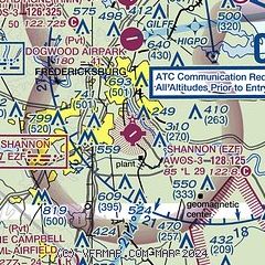
|
CAUTION: Diagram may not be current

| Airport distance calculator |
|---|
|
|
| Sunrise and sunset |
|---|
|
Times for 24-Dec-2025
| | Local
(UTC-5) | | Zulu
(UTC) |
|---|
| Morning civil twilight | | 06:56 | | 11:56 |
| Sunrise | | 07:25 | | 12:25 |
| Sunset | | 16:53 | | 21:53 |
| Evening civil twilight | | 17:23 | | 22:23 |
|
| Current date and time |
|---|
| Zulu (UTC) | 25-Dec-2025 02:01:32 |
|---|
| Local (UTC-5) | 24-Dec-2025 21:01:32 |
|---|
|
| METAR |
|---|
| KEZF | 250155Z AUTO 00000KT 10SM CLR 05/M02 A3028 RMK AO2 T00451025
|
KRMN
8nm N | 250155Z AUTO 00000KT 10SM CLR 05/M05 A3029 RMK AO2 T00501053
|
KNYG
16nm NE | 250156Z AUTO 00000KT CLR 07/M03 A3031 RMK AO2 SLP264 T00671028 $
|
|
| NOTAMs |
|---|
NOTAMs are issued by the DoD/FAA and will open in a separate window not controlled by AirNav.
|
|


