FAA INFORMATION EFFECTIVE 20 MARCH 2025
Location
| FAA Identifier: | EZS |
| Lat/Long: | 44-47-14.3010N 088-33-36.0450W
44-47.238350N 088-33.600750W
44.7873058,-88.5600125
(estimated) |
| Elevation: | 813.1 ft. / 247.8 m (surveyed) |
| Variation: | 02W (1995) |
| From city: | 1 mile NE of SHAWANO, WI |
| Time zone: | UTC -5 (UTC -6 during Standard Time) |
| Zip code: | 54166 |
Airport Operations
| Airport use: | Open to the public |
| Activation date: | 03/1945 |
| Control tower: | no |
| ARTCC: | MINNEAPOLIS CENTER |
| FSS: | GREEN BAY FLIGHT SERVICE STATION |
| NOTAMs facility: | GRB (NOTAM-D service available) |
| Attendance: | MON-SAT 0800-1800 |
| Wind indicator: | lighted |
| Segmented circle: | no |
| Lights: | MIRL RWY 12/30 PRESET LOW SS-SR; TO INCR INTST AND ACTVT REIL RWY 30; MIRL RWY 17/35 - CTAF. PAPI RWY 30 OPS CONSLY. |
| Beacon: | white-green (lighted land airport)
ROTG BCN LCTD ON ARPT. Operates sunset to sunrise. |
Airport Communications
| CTAF/UNICOM: | 122.8 |
| WX AWOS-3: | 118.65 (715-526-2967) |
| GREEN BAY APPROACH: | 119.4 |
| GREEN BAY DEPARTURE: | 119.4 |
| WX AWOS-3 at CLI (13 nm SW): | 120.675 (715-823-7691) |
- APCH/DEP SVC PRVDD BY MINNEAPOLIS ARTCC ON FREQS 124.4/317.7 (MOSINEE RCAG) WHEN GREEN BAY APCH CTL CLSD.
Nearby radio navigation aids
| VOR radial/distance | | VOR name | | Freq | | Var |
|---|
| GRBr311/20.9 | | GREEN BAY VORTAC | | 115.50 | | 01E |
Airport Services
| Fuel available: | 100LL
100LL:24 HR FUEL AVBL WITH CREDIT CARD. |
| Parking: | hangars and tiedowns |
Runway Information
Runway 12/30
| Dimensions: | 3901 x 75 ft. / 1189 x 23 m |
| Surface: | asphalt, in excellent condition |
| Weight bearing capacity: | |
| Runway edge lights: | medium intensity |
| RUNWAY 12 | | RUNWAY 30 |
| Latitude: | 44-47.362643N | | 44-47.116793N |
| Longitude: | 088-34.004937W | | 088-33.172258W |
| Elevation: | 810.9 ft. | | 811.0 ft. |
| Traffic pattern: | left | | left |
| Runway heading: | 115 magnetic, 113 true | | 295 magnetic, 293 true |
| Markings: | nonprecision, in good condition | | nonprecision, in good condition |
| Visual slope indicator: | | | 2-light PAPI on left (3.00 degrees glide path) |
| Runway end identifier lights: | no | | yes |
| Touchdown point: | yes, no lights | | yes, no lights |
| Obstructions: | 14 ft. road, 370 ft. from runway, 260 ft. left of centerline, 12:1 slope to clear | | none |
Runway 17/35
| Dimensions: | 2225 x 60 ft. / 678 x 18 m |
| Surface: | asphalt, in fair condition |
| Runway edge lights: | medium intensity |
| RUNWAY 17 | | RUNWAY 35 |
| Latitude: | 44-47.412622N | | 44-47.059198N |
| Longitude: | 088-33.689235W | | 088-33.554918W |
| Elevation: | 809.0 ft. | | 813.1 ft. |
| Traffic pattern: | left | | left |
| Runway heading: | 167 magnetic, 165 true | | 347 magnetic, 345 true |
| Markings: | basic, in fair condition | | basic, in fair condition |
| Runway end identifier lights: | no | | no |
| Touchdown point: | yes, no lights | | yes, no lights |
| Obstructions: | 20 ft. tree, 550 ft. from runway, 65 ft. right of centerline, 17:1 slope to clear | | 39 ft. tree, 600 ft. from runway, 125 ft. left of centerline, 10:1 slope to clear |
Runway ALL/WAY
| Dimensions: | 12000 x 1000 ft. / 3658 x 305 m |
| Surface: | water |
| RUNWAY ALL | | RUNWAY WAY |
| Traffic pattern: | left | | left |
Airport Ownership and Management from official FAA records
| Ownership: | Publicly-owned |
| Owner: | SHAWANO CITY AND CO
127 S SAWYER STREET
SHAWANO, WI 54166
Phone 715-526-6138 |
| Manager: | COLIN ISOM
248 AIRPORT RD
SHAWANO, WI 54166
Phone 715-526-2465
ADDNL PHONE 715-584-1750. |
Additional Remarks
| - | FOR CD CTC GREEN BAY APCH AT 920-431-5741. WHEN APCH CLSD, CTC MINNEAPOLIS ARTCC AT 651-463-5588. |
| - | WATERFOWL & DEER ON & INVOF ARPT. |
| - | SPB HAS TIE DOWNS & BEACHING RAMP. |
| - | SEAPLANE WATERWAY CLSD EARLY NOV TO EARLY MAY, CALL AMGR 715-526-2465 FOR COND. |
Instrument Procedures
NOTE: All procedures below are presented as PDF files. If you need a reader for these files, you should download the free Adobe Reader.NOT FOR NAVIGATION. Please procure official charts for flight.
FAA instrument procedures published for use from 20 March 2025 at 0901Z to 17 April 2025 at 0900z.
IAPs - Instrument Approach Procedures |
|---|
| RNAV (GPS) RWY 12 | |
download (212KB) |
| RNAV (GPS) RWY 30 | |
download (209KB) |
| NOTE: Special Alternate Minimums apply | |
download (139KB) |
| NOTE: Special Take-Off Minimums/Departure Procedures apply | |
download (270KB) |
Other nearby airports with instrument procedures:
KCLI - Clintonville Municipal Airport (13 nm SW)
KGRB - Green Bay/Austin Straubel International Airport (26 nm SE)
KOCQ - Oconto/J Douglas Bake Municipal Airport (28 nm E)
KATW - Appleton International Airport (32 nm S)
KAIG - Langlade County Airport (32 nm NW)
|
|

Road maps at:
MapQuest
Bing
Google
| Aerial photo |
|---|
WARNING: Photo may not be current or correct
 Photo taken 09-Aug-2008
Do you have a better or more recent aerial photo of Shawano Municipal Airport that you would like to share? If so, please send us your photo.
|
| Sectional chart |
|---|
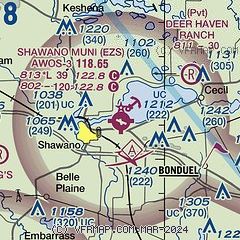
|
| Airport distance calculator |
|---|
|
|
| Sunrise and sunset |
|---|
|
Times for 13-Apr-2025
| | Local
(UTC-5) | | Zulu
(UTC) |
|---|
| Morning civil twilight | | 05:44 | | 10:44 |
| Sunrise | | 06:14 | | 11:14 |
| Sunset | | 19:35 | | 00:35 |
| Evening civil twilight | | 20:06 | | 01:06 |
|
| Current date and time |
|---|
| Zulu (UTC) | 13-Apr-2025 16:51:21 |
|---|
| Local (UTC-5) | 13-Apr-2025 11:51:21 |
|---|
|
| METAR |
|---|
| KEZS | 715-526-2967
131635Z AUTO 14011G17KT 10SM CLR 17/01 A2977 RMK AO2 T01680006
|
KCLI
13nm SW | 131635Z AUTO 17014KT 10SM CLR 16/03 A2978 RMK AO2 T01570034
|
|
| TAF |
|---|
KGRB
26nm SE | 131127Z 1312/1412 16011KT P6SM BKN100 FM131500 16013G22KT P6SM BKN120 FM131900 16013G22KT P6SM BKN045 TEMPO 1319/1322 6SM -SHRA BKN035 FM132200 16011G23KT P6SM BKN035 FM140000 15007G18KT P6SM BKN035 FM140500 18006KT P6SM BKN025 FM140900 24010G19KT P6SM BKN060
|
|
| NOTAMs |
|---|
NOTAMs are issued by the DoD/FAA and will open in a separate window not controlled by AirNav.
|
|


