FAA INFORMATION EFFECTIVE 11 JUNE 2026
Location
| FAA Identifier: | F69 |
| Lat/Long: | 33-01-24.4370N 096-50-13.0060W
33-01.407283N 096-50.216767W
33.0234547,-96.8369461
(estimated) |
| Elevation: | 695 ft. / 212 m (estimated) |
| Variation: | 07E (1985) |
| From city: | 16 miles NE of DALLAS, TX |
| Time zone: | UTC -5 (UTC -6 during Standard Time) |
| Zip code: | 75093 |
Airport Operations
| Airport use: | Open to the public |
| Control tower: | no |
| ARTCC: | FORT WORTH CENTER |
| FSS: | FORT WORTH FLIGHT SERVICE STATION |
| NOTAMs facility: | FTW (NOTAM-D service available) |
| Attendance: | UNATNDD |
| Wind indicator: | yes |
| Segmented circle: | no |
Airport Communications
| CTAF: | 122.9 |
| WX AWOS-3PT at ADS (3 nm S): | PHONE 972-386-4855 |
| WX ASOS at DAL (11 nm S): | PHONE 214-353-1551 |
| WX ASOS at DFW (13 nm SW): | PHONE 214-600-7784 |
| WX AWOS-3 at 49T (15 nm S): | 135.425 (214-670-1243) |
| WX ASOS at TKI (16 nm NE): | PHONE 972-548-8525 |
- ARPT INSIDE ADDISON CLASS D AIRSPACE. CTC ADDISON TOWER 126.0 (0600-2200).
Nearby radio navigation aids
| VOR radial/distance | | VOR name | | Freq | | Var |
|---|
| CVEr017/8.7 | | COWBOY VOR/DME | | 116.20 | | 06E |
| TTTr042/13.8 | | MAVERICK VOR/DME | | 113.10 | | 06E |
| FUZr059/19.0 | | RANGER VORTAC | | 115.70 | | 06E |
Airport Services
| Parking: | tiedowns |
| Airframe service: | MAJOR |
| Powerplant service: | MAJOR |
Runway Information
Runway 16/34
| Dimensions: | 3080 x 30 ft. / 939 x 9 m |
| Surface: | asphalt, in poor condition |
| Runway edge markings: | MKD WITH 300 FT DSPLCD THR, NSTD SIZE ARROWS. |
| RUNWAY 16 | | RUNWAY 34 |
| Traffic pattern: | left | | right |
| Displaced threshold: | 300 ft. | | no |
| Markings: | NSTD, in good condition | | NSTD, in good condition |
| Obstructions: | 13 ft. pole, marked and lighted, 202 ft. from runway, 10 ft. left of centerline
4 FT FENCE, 0-50 FT DSTC, 84 FT L-125 FT R., 15 FT RD, 0-132 FT DSTC, 125 FT L/R. | | 48 ft. trees, lighted, 459 ft. from runway, 64 ft. left of centerline, 5:1 slope to clear
4 FT FENCE 0 FT DSTC 125 FT L-88 FT R; 15 FT RD 100 FT R; 30 FT TREES, 0 FT DSTC, 122 FT L. |
Airport Ownership and Management from official FAA records
| Ownership: | Privately-owned |
| Owner: | CROW BILLINGSLEY AIRPARK LTD
1722 ROUTH ST STE 707
DALLAS , TX 75201
Phone 214-693-0513 |
| Manager: | BECKY ROWLAND
1722 ROUTH ST STE 707
DALLAS, TX 75201
Phone 214-693-0513 |
Additional Remarks
| - | FOR CD CTC LONE STAR APCH AT 972-615-2799. |
| - | RWY 34 APCH, OBSTN LGT ON BLDG IS LWR THAN OBSTNS CLOSER TO RWY END. |
| - | RWY 16 APCH, OBSTN LGTS LWR THAN OBSTNS. |
| - | AIRPORT INSIDE ADDISON (ADS) CLASS D AIRSPACE. CTC ADS TWR 126.0 WHEN AIRBORNE. |
Instrument Procedures
There are no published instrument procedures at F69.
Some nearby airports with instrument procedures:
KADS - Addison Airport (3 nm S)
KDAL - Dallas Love Field Airport (11 nm S)
KDFW - Dallas-Fort Worth International Airport (13 nm SW)
KTKI - McKinney National Airport (16 nm NE)
KRBD - Dallas Executive Airport (21 nm S)
|
|

Road maps at:
MapQuest
Bing
Google
| Aerial photo |
|---|
WARNING: Photo may not be current or correct
 Photo by K. Bruggers
Do you have a better or more recent aerial photo of Air Park-Dallas Airport that you would like to share? If so, please send us your photo.
|
| Sectional chart |
|---|
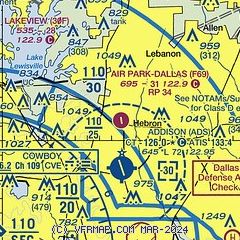
|
| Airport distance calculator |
|---|
|
|
| Sunrise and sunset |
|---|
|
Times for 15-Jun-2026
| | Local
(UTC-5) | | Zulu
(UTC) |
|---|
| Morning civil twilight | | 05:50 | | 10:50 |
| Sunrise | | 06:19 | | 11:19 |
| Sunset | | 20:36 | | 01:36 |
| Evening civil twilight | | 21:05 | | 02:05 |
|
| Current date and time |
|---|
| Zulu (UTC) | 15-Jun-2026 08:59:46 |
|---|
| Local (UTC-5) | 15-Jun-2026 03:59:46 |
|---|
|
| METAR |
|---|
KADS
4nm S | 150835Z AUTO 04007KT 10SM OVC030 24/22 A3000 RMK AO2
|
KDAL
10nm S | 150853Z 01004KT 10SM BKN028 BKN250 24/20 A3000 RMK AO2 SLP150 T02440200 56009
|
KDFW
12nm SW | 150853Z 04006KT 10SM OVC030 24/20 A2999 RMK AO2 SLP145 T02390200 56010
|
KTKI
16nm NE | 150853Z AUTO 04004KT 10SM OVC030 23/21 A3000 RMK AO2 SLP155 T02280211 58011 $
|
|
| TAF |
|---|
KDAL
10nm S | 150537Z 1506/1606 03010KT P6SM SCT025 BKN035 FM150800 02007KT P6SM BKN022 FM151100 01009KT P6SM VCSH OVC017 FM151800 03007KT P6SM BKN025 FM152300 06007KT P6SM SCT025 BKN050
|
KDFW
12nm SW | 150537Z 1506/1612 03010KT P6SM SCT025 BKN040 FM150800 02007KT P6SM BKN022 FM151100 01009KT P6SM VCSH OVC017 FM151800 03007KT P6SM BKN025 FM152300 06007KT P6SM SCT025 BKN050 FM160600 05006KT P6SM BKN015
|
|
| NOTAMs |
|---|
NOTAMs are issued by the DoD/FAA and will open in a separate window not controlled by AirNav.
|
|


