FAA INFORMATION EFFECTIVE 17 APRIL 2025
Location
| FAA Identifier: | GDM |
| Lat/Long: | 42-32-59.6000N 072-00-57.7000W
42-32.993333N 072-00.961667W
42.5498889,-72.0160278
(estimated) |
| Elevation: | 954.1 ft. / 290.8 m (surveyed) |
| Variation: | 14W (1970) |
| From city: | 2 miles SW of GARDNER, MA |
| Time zone: | UTC -4 (UTC -5 during Standard Time) |
| Zip code: | 01440 |
Airport Operations
| Airport use: | Open to the public |
| Activation date: | 04/1940 |
| Control tower: | no |
| ARTCC: | BOSTON CENTER |
| FSS: | BRIDGEPORT FLIGHT SERVICE STATION |
| NOTAMs facility: | BDR (NOTAM-D service available) |
| Attendance: | IREG |
| Wind indicator: | yes |
| Segmented circle: | no |
| Lights: | ACTVT REIL RWY 18 & 36; MIRL RWY 18/36 - CTAF. |
| Beacon: | white-green (lighted land airport)
Operates sunset to sunrise. |
Airport Communications
| CTAF/UNICOM: | 122.8 |
| WX ASOS at FIT (11 nm E): | 135.175 (978-343-9121) |
| WX ASOS at ORE (12 nm W): | 135.675 (978-544-6774) |
| WX ASOS at AFN (15 nm N): | 135.875 (603-532-6195) |
| WX ASOS at ORH (18 nm S): | PHONE 508-795-7546 |
- APCH/DEP SVC PRVDD BY BOSTON ARTCC ON FREQS 123.75/338.2 (GARDNER RCAG).
Nearby radio navigation aids
| VOR radial/distance | | VOR name | | Freq | | Var |
|---|
| GDMr097/1.9 | | GARDNER VOR/DME | | 116.95 | | 14W |
| PUTr002/36.5 | | PUTNAM VOR/DME | | 117.40 | | 14W |
| BAFr067/38.8 | | BARNES VORTAC | | 113.00 | | 14W |
Airport Services
| Fuel available: | 100LL |
| Parking: | tiedowns |
| Airframe service: | MINOR |
| Powerplant service: | MINOR |
| Bottled oxygen: | NONE |
| Bulk oxygen: | NONE |
Runway Information
Runway 18/36
| Dimensions: | 3000 x 75 ft. / 914 x 23 m |
| Surface: | asphalt, in good condition |
| Weight bearing capacity: | |
| Runway edge lights: | medium intensity |
| RUNWAY 18 | | RUNWAY 36 |
| Latitude: | 42-33.231030N | | 42-32.754425N |
| Longitude: | 072-01.048385W | | 072-00.873765W |
| Elevation: | 954.1 ft. | | 923.8 ft. |
| Traffic pattern: | left | | left |
| Runway heading: | 179 magnetic, 165 true | | 359 magnetic, 345 true |
| Markings: | basic, in good condition | | basic, in good condition |
| Runway end identifier lights: | yes | | yes |
| Touchdown point: | yes, no lights | | yes, no lights |
| Obstructions: | 150 ft. trees, 800 ft. from runway, 130 ft. right of centerline, 4:1 slope to clear | | 15 ft. trees, 300 ft. from runway, 125 ft. both sides of centerline, 6:1 slope to clear |
Airport Ownership and Management from official FAA records
| Ownership: | Publicly-owned |
| Owner: | CITY OF GARDNER
95 PLEASANT STREET
GARDNER, MA 01440
Phone 978-790-7779 |
| Manager: | ISABELLE DAVIS
GARDNER CITY HALL, 95 PLEASANT ST, ROOM 214
GARDNER, MA 01440
Phone 978-790-7779 |
Additional Remarks
| - | NORDO ACFT ON AND INVOF ARPT. |
| - | WILDLIFE ON AND IN VCNTY OF ARPT. |
Instrument Procedures
NOTE: All procedures below are presented as PDF files. If you need a reader for these files, you should download the free Adobe Reader.NOT FOR NAVIGATION. Please procure official charts for flight.
FAA instrument procedures published for use from 17 April 2025 at 0901Z to 15 May 2025 at 0900z.
IAPs - Instrument Approach Procedures |
|---|
| RNAV (GPS)-B **CHANGED** | |
download (212KB) |
| VOR-A **CHANGED** | |
download (182KB) |
| NOTE: Special Take-Off Minimums/Departure Procedures apply | |
download (178KB) |
Other nearby airports with instrument procedures:
KFIT - Fitchburg Municipal Airport (11 nm E)
KORE - Orange Municipal Airport (12 nm W)
KAFN - Jaffrey Airfield Silver Ranch (15 nm N)
KORH - Worcester Regional Airport (18 nm S)
0B5 - Turners Falls Airport (23 nm W)
|
|

Road maps at:
MapQuest
Bing
Google
| Aerial photo |
|---|
WARNING: Photo may not be current or correct
 Photo by Bruce Vinal, Aerial Perspectives
Photo taken 27-Aug-2010
looking North.
Photo by Bruce Vinal, Aerial Perspectives
Photo taken 27-Aug-2010
looking North.
Do you have a better or more recent aerial photo of Gardner Municipal Airport that you would like to share? If so, please send us your photo.
|
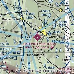
| Sectional chart |
|---|
|
| Airport distance calculator |
|---|
|
|
| Sunrise and sunset |
|---|
|
Times for 22-Apr-2025
| | Local
(UTC-4) | | Zulu
(UTC) |
|---|
| Morning civil twilight | | 05:27 | | 09:27 |
| Sunrise | | 05:57 | | 09:57 |
| Sunset | | 19:36 | | 23:36 |
| Evening civil twilight | | 20:06 | | 00:06 |
|
| Current date and time |
|---|
| Zulu (UTC) | 22-Apr-2025 23:38:18 |
|---|
| Local (UTC-4) | 22-Apr-2025 19:38:18 |
|---|
|
| METAR |
|---|
KFIT
12nm E | 222252Z AUTO 30005KT 10SM CLR 22/04 A2991 RMK AO2 SLP128 T02220044
|
KORE
12nm W | 222252Z AUTO 00000KT 10SM CLR 21/04 A2992 RMK AO2 SLP132 T02110044
|
KAFN
15nm N | 222252Z AUTO 28008G15KT 10SM CLR 19/02 A2993 RMK AO2 SLP142 T01940022
|
KORH
18nm S | 222254Z 28009KT 10SM CLR 21/05 A2992 RMK AO2 SLP133 T02060050
|
KEEN
23nm NW | 222256Z AUTO 27008KT 10SM CLR 20/03 A2993 RMK AO2 SLP136 T02000028 $
|
|
| TAF |
|---|
KORH
18nm S | 221720Z 2218/2318 27012G22KT P6SM FEW250 FM222200 28010KT P6SM FEW250
|
|
| NOTAMs |
|---|
NOTAMs are issued by the DoD/FAA and will open in a separate window not controlled by AirNav.
|
|


