FAA INFORMATION EFFECTIVE 16 APRIL 2026
Location
| FAA Identifier: | H58 |
| Lat/Long: | 37-11-02.5800N 092-44-13.3900W
37-11.043000N 092-44.223167W
37.1840500,-92.7370528
(estimated) |
| Elevation: | 1593 ft. / 486 m (estimated) |
| Variation: | 04E (1985) |
| From city: | 3 miles NE of SEYMOUR, MO |
| Time zone: | UTC -5 (UTC -6 during Standard Time) |
| Zip code: | 65746 |
Airport Operations
| Airport use: | Open to the public |
| Activation date: | 01/1946 |
| Control tower: | no |
| ARTCC: | KANSAS CITY CENTER |
| FSS: | COLUMBIA FLIGHT SERVICE STATION |
| NOTAMs facility: | COU (NOTAM-D service available) |
| Attendance: | UNATNDD |
| Wind indicator: | yes |
| Segmented circle: | no |
Airport Communications
Nearby radio navigation aids
| VOR radial/distance | | VOR name | | Freq | | Var |
|---|
| DGDr034/11.7 | | DOGWOOD VORTAC | | 109.40 | | 01E |
| SGFr106/30.3 | | SPRINGFIELD VORTAC | | 116.90 | | 04E |
Airport Services
Runway Information
Runway 1/19
| Dimensions: | 2800 x 45 ft. / 853 x 14 m |
| Surface: | turf, in excellent condition
FIRST 1000 FT OF RY 19 HAS A VERY STEEP SLP WITH OBSTNS AT RY END. |
| RUNWAY 1 | | RUNWAY 19 |
| Elevation: | 1593.0 ft. | | 1553.0 ft. |
| Traffic pattern: | left | | left |
| Obstructions: | 5 ft. fence, 125 ft. left and right of centerline | | 36 ft. trees, 265 ft. from runway, 50 ft. left of centerline, 7:1 slope to clear |
Runway 15/33
| Dimensions: | 1725 x 25 ft. / 526 x 8 m |
| Surface: | turf, in excellent condition
RY SFC ROUGH; ROLLING, UNEVEN & NARROW WITH TALL OBSTNS AT RY END. |
| RUNWAY 15 | | RUNWAY 33 |
| Latitude: | 37-11.169333N | | 37-10.916667N |
| Longitude: | 092-44.304667W | | 092-44.141667W |
| Elevation: | 1555.0 ft. | | 1577.0 ft. |
| Traffic pattern: | left | | left |
| Obstructions: | 62 ft. trees, 290 ft. from runway, 30 ft. left of centerline, 4:1 slope to clear | | 32 ft. trees, 200 ft. from runway, 50 ft. left of centerline, 6:1 slope to clear |
Airport Ownership and Management from official FAA records
| Ownership: | Privately-owned |
| Owner: | KEVIN WRIGHT
BOX 223 1 OWEN DRIVE
SEYMOUR, MO 65746
Phone 417-848-0075 |
| Manager: | KEVIN WRIGHT
442 HWY V
SEYMOUR, MO 65746
Phone 417-848-0075
ALTN PHONE NBR 417-848-0075 |
Additional Remarks
| - | WILDLIFE ON & INVOF ARPT. |
| - | AFT HVY RAINS CALL 417-848-0075 FOR RY CONDS. |
| - | LN OF SIGHT FM RY ENDS OBSTD BY CHGS IN RY GRADE. |
| - | NTSD RY SAFETY AREAS BYD EACH RY END; INCORRECT TERRAIN GRADS, FENCES, CONCRETE FENCE POSTS, TREES, BRUSH, DITCHES, & BLDGS. |
| - | FOR CD CTC SPRINGFIELD APCH AT 417-868-5620/5619. |
Instrument Procedures
There are no published instrument procedures at H58.
Some nearby airports with instrument procedures:
KAOV - Ava Bill Martin Memorial Airport (13 nm S)
1MO - Mountain Grove Memorial Airport (21 nm E)
3DW - Downtown Airport (25 nm W)
KLBO - Floyd W Jones Lebanon Airport (28 nm N)
KSGF - Springfield-Branson National Airport (31 nm W)
|
|

Road maps at:
MapQuest
Bing
Google
| Aerial photo |
|---|

|
| Sectional chart |
|---|
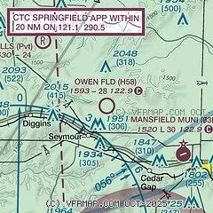
|
| Airport distance calculator |
|---|
|
|
| Sunrise and sunset |
|---|
|
Times for 09-May-2026
| | Local
(UTC-5) | | Zulu
(UTC) |
|---|
| Morning civil twilight | | 05:40 | | 10:40 |
| Sunrise | | 06:09 | | 11:09 |
| Sunset | | 20:06 | | 01:06 |
| Evening civil twilight | | 20:35 | | 01:35 |
|
| Current date and time |
|---|
| Zulu (UTC) | 09-May-2026 17:41:08 |
|---|
| Local (UTC-5) | 09-May-2026 12:41:08 |
|---|
|
| METAR |
|---|
KLBO
28nm N | 091715Z AUTO 28010G14KT 10SM CLR 25/11 A2987 RMK AO2
|
KSGF
31nm W | 091652Z 28009KT 10SM CLR 24/11 A2986 RMK AO2 SLP105 T02440106
|
KFWB
43nm SW | 091715Z AUTO VRB03KT 9SM 25/12 A2987 RMK AO2 TSNO
|
KTBN
44nm NE | 091655Z AUTO 29005KT 10SM CLR 24/12 A2983 RMK AO2 SLP097 T02410124
|
KUNO
44nm SE | 091653Z AUTO VRB04KT 10SM CLR 25/09 A2987 RMK AO2 SLP105 T02500089
|
KBBG
45nm SW | 091645Z 00000KT 10SM CLR 24/12 A2990
|
KOZS
47nm N | 091715Z AUTO 28012G18KT 10SM CLR 24/10 A2986 RMK AO2
|
|
| TAF |
|---|
KSGF
31nm W | 091120Z 0912/1012 VRB05KT P6SM FEW250 FM091500 28007KT P6SM SKC FM100300 VRB05KT P6SM BKN120
|
|
| NOTAMs |
|---|
NOTAMs are issued by the DoD/FAA and will open in a separate window not controlled by AirNav.
|
|


