FAA INFORMATION EFFECTIVE 15 MAY 2025
Location
| FAA Identifier: | HTF |
| Lat/Long: | 42-22-55.7000N 077-40-55.6000W
42-22.928333N 077-40.926667W
42.3821389,-77.6821111
(estimated) |
| Elevation: | 1219.4 ft. / 371.7 m (surveyed) |
| Variation: | 11W (2000) |
| From city: | 3 miles N of HORNELL, NY |
| Time zone: | UTC -4 (UTC -5 during Standard Time) |
| Zip code: | 14843 |
Airport Operations
| Airport use: | Open to the public |
| Activation date: | 02/1940 |
| Control tower: | no |
| ARTCC: | CLEVELAND CENTER |
| FSS: | BUFFALO FLIGHT SERVICE STATION |
| NOTAMs facility: | BUF (NOTAM-D service available) |
| Attendance: | 0800-1600 |
| Pattern altitude: | 2219.4 ft. MSL
TPA: 1000 FT AGL DALGT, 1200 FT AGL NGT. |
| Wind indicator: | lighted |
| Segmented circle: | yes |
| Lights: | ACTVT REIL RWY 18 & 36; MIRL RWY 18/36 - CTAF. |
| Beacon: | white-green (lighted land airport)
Operates sunset to sunrise. |
Airport Communications
| CTAF/UNICOM: | 122.7 |
| WX AWOS-3: | 118.475 (607-324-9138) |
| WX ASOS at DSV (11 nm N): | 118.325 (585-335-2380) |
- APCH/DEP SVC PRVDD BY CLEVELAND ARTCC (ZOB) ON FREQS 124.325/353.850 (WAYLAND RCAG).
Nearby radio navigation aids
| VOR radial/distance | | VOR name | | Freq | | Var |
|---|
| GEEr184/27.2 | | GENESEO VOR/DME | | 108.20 | | 09W |
Airport Services
| Fuel available: | 100LL JET-A |
| Parking: | hangars and tiedowns |
| Airframe service: | NONE |
| Powerplant service: | NONE |
| Bottled oxygen: | NONE |
| Bulk oxygen: | NONE |
Runway Information
Runway 18/36
| Dimensions: | 5000 x 75 ft. / 1524 x 23 m |
| Surface: | asphalt/grooved, in good condition |
| Runway edge lights: | medium intensity |
| RUNWAY 18 | | RUNWAY 36 |
| Latitude: | 42-23.324508N | | 42-22.532285N |
| Longitude: | 077-41.077615W | | 077-40.776338W |
| Elevation: | 1219.4 ft. | | 1193.5 ft. |
| Traffic pattern: | left | | left |
| Runway heading: | 175 magnetic, 164 true | | 355 magnetic, 344 true |
| Displaced threshold: | 500 ft. | | no |
| Markings: | basic, in good condition | | basic, in good condition |
| Visual slope indicator: | | | 4-light PAPI on left (3.00 degrees glide path)
PAPI UNUSBL BYD 5 DEGS RIGHT & LEFT OF CNTRLN. |
| Runway end identifier lights: | yes
REILS RWY 18 OTS INDEFLY. | | yes |
| Touchdown point: | yes, no lights | | yes, no lights |
| Obstructions: | 147 ft. hill, 2129 ft. from runway, 340 ft. left of centerline, 13:1 slope to clear
RWY 18 CLNC SLOPE 17:1 TO DTHR. | | 13 ft. trees, 219 ft. from runway, 182 ft. left of centerline, 1:1 slope to clear |
Airport Ownership and Management from official FAA records
| Ownership: | Publicly-owned |
| Owner: | CITY OF HORNELL
CITY HALL/PO BOX 627
HORNELL, NY 14843
Phone 607-324-7421
SHAWN HOGAN, MAYOR |
| Manager: | MITCHELL CORNISH
1100 AIRPORT ROAD
HORNELL, NY 14843
Phone 607-968-9624 |
Additional Remarks
| - | FREQUENT HELICOPTER MEDIVAC OPERATIONS - MONITOR CTAF. |
| - | FOR APCH/DEP CTC CLEVELAND ARTCC AT 440-774-0227. |
| - | FOR CD CTC CLEVELAND ARTCC AT 440-774-0227. |
| - | COLD TEMPERATURE AIRPORT. ALTITUDE CORRECTION REQUIRED AT OR BELOW -19C. |
Instrument Procedures
NOTE: All procedures below are presented as PDF files. If you need a reader for these files, you should download the free Adobe Reader.NOT FOR NAVIGATION. Please procure official charts for flight.
FAA instrument procedures published for use from 15 May 2025 at 0901Z to 13 June 2025 at 0900z.
IAPs - Instrument Approach Procedures |
|---|
| RNAV (GPS) RWY 18 | |
download (231KB) |
| RNAV (GPS) RWY 36 | |
download (269KB) |
| NOTE: Special Take-Off Minimums/Departure Procedures apply | |
download (150KB) |
Other nearby airports with instrument procedures:
KDSV - Dansville Municipal Airport (11 nm N)
KELZ - Wellsville Municipal Airport/Tarantine Field (21 nm SW)
KOLE - Cattaraugus County-Olean Airport (32 nm W)
KPEO - Penn Yan/Yates County Airport (32 nm NE)
KIUA - Canandaigua Airport (35 nm NE)
|
|

Road maps at:
MapQuest
Bing
Google
| Aerial photo |
|---|
WARNING: Photo may not be current or correct
 Photo taken 24-May-2008
from Mercy Flight Central 6 (N935MC)
Photo taken 24-May-2008
from Mercy Flight Central 6 (N935MC)
Do you have a better or more recent aerial photo of Hornell Municipal Airport that you would like to share? If so, please send us your photo.
|
| Sectional chart |
|---|
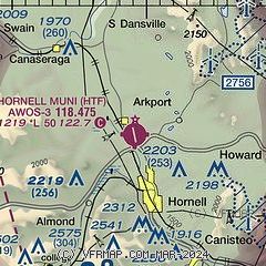
|
| Airport distance calculator |
|---|
|
|
| Sunrise and sunset |
|---|
|
Times for 22-May-2025
| | Local
(UTC-4) | | Zulu
(UTC) |
|---|
| Morning civil twilight | | 05:11 | | 09:11 |
| Sunrise | | 05:44 | | 09:44 |
| Sunset | | 20:31 | | 00:31 |
| Evening civil twilight | | 21:04 | | 01:04 |
|
| Current date and time |
|---|
| Zulu (UTC) | 22-May-2025 07:25:44 |
|---|
| Local (UTC-4) | 22-May-2025 03:25:44 |
|---|
|
| METAR |
|---|
KDSV
11nm N | 220654Z AUTO 14012G19KT 10SM BKN024 OVC031 12/07 A2970 RMK AO2 SLP066 T01170072
|
KELZ
22nm SW | 220656Z AUTO 15010G23KT 10SM -RA OVC010 08/06 A2969 RMK AO2 PK WND 14027/0634 RAE12B53 SLP060 P0000 T00780061
|
|
| TAF |
|---|
KELM
37nm E | 220542Z 2206/2306 VRB04KT 5SM -SHRA BR OVC012 FM221100 14008G16KT 5SM -RA BR OVC011 FM222100 13004KT 5SM -RA BR OVC012
|
KROC
44nm N | 220527Z 2206/2306 13012G20KT 6SM -RA OVC020 FM220700 12012G21KT 6SM -RA OVC015 FM221000 12011G18KT 6SM -RA OVC007 FM222300 12009KT 6SM -RA OVC007 FM230100 12008KT 6SM -RA OVC012
|
|
| NOTAMs |
|---|
NOTAMs are issued by the DoD/FAA and will open in a separate window not controlled by AirNav.
|
|


