FAA INFORMATION EFFECTIVE 09 JULY 2026
Location
| FAA Identifier: | IKK |
| Lat/Long: | 41-04-17.0000N 087-50-46.6000W
41-04.283333N 087-50.776667W
41.0713889,-87.8462778
(estimated) |
| Elevation: | 629.5 ft. / 191.9 m (surveyed) |
| Variation: | 04W (2020) |
| From city: | 3 miles S of KANKAKEE, IL |
| Time zone: | UTC -5 (UTC -6 during Standard Time) |
| Zip code: | 60901 |
Airport Operations
| Airport use: | Open to the public |
| Control tower: | no |
| ARTCC: | CHICAGO CENTER |
| FSS: | KANKAKEE FLIGHT SERVICE STATION |
| NOTAMs facility: | IKK (NOTAM-D service available) |
| Attendance: | 0730-1730 |
| Wind indicator: | lighted |
| Segmented circle: | yes |
| Lights: | ACTVT MALSR RWY 04; REIL RWY 22; HIRL RWY 04/22; MIRL RWY 16/34 - CTAF. HIRL RWY 04/22 PRESET TO LOW INTST; TO INCR INTST - CTAF. |
| Beacon: | white-green (lighted land airport)
Operates sunset to sunrise. |
Airport Communications
| CTAF/UNICOM: | 123.0 |
| WX AWOS-3: | 128.475 (815-939-4044) |
| WX AWOS-AV at C56 (20 nm N): | 119.125 (708-534-5256) |
- APCH/DEP SVC PRVDD BY CHICAGO ARTCC (ZAU) ON FREQS 132.5/284.7 (KANKAKEE RCAG).
Nearby radio navigation aids
| VOR radial/distance | | VOR name | | Freq | | Var |
|---|
| EONr190/12.2 | | PEOTONE VORTAC | | 113.20 | | 02E |
| CGTr203/29.1 | | CHICAGO HEIGHTS VORTAC | | 114.20 | | 02E |
| RBSr024/32.7 | | ROBERTS VOR/DME | | 116.80 | | 02E |
| JOTr141/35.6 | | JOLIET VOR/DME | | 112.30 | | 02E |
| NDB name | | Hdg/Dist | | Freq | | Var | | ID |
|---|
| LUKOW | | 043/4.1 | | 272 | | 04W | | IK | .. -.- |
Airport Services
| Fuel available: | 100LL JET-A |
| Parking: | hangars and tiedowns |
| Airframe service: | MINOR |
| Powerplant service: | MINOR |
| Bottled oxygen: | NONE |
| Bulk oxygen: | NONE |
Runway Information
Runway 4/22
| Dimensions: | 5981 x 100 ft. / 1823 x 30 m |
| Surface: | asphalt/porous friction courses, in good condition |
| Weight bearing capacity: | | Single wheel: | 60.0 | | Double wheel: | 95.0 |
|
| Runway edge lights: | high intensity |
| RUNWAY 4 | | RUNWAY 22 |
| Latitude: | 41-03.947348N | | 41-04.720030N |
| Longitude: | 087-51.292812W | | 087-50.485720W |
| Elevation: | 624.2 ft. | | 629.5 ft. |
| Traffic pattern: | left | | left |
| Runway heading: | 042 magnetic, 038 true | | 222 magnetic, 218 true |
| Markings: | precision, in good condition | | nonprecision, in good condition |
| Visual slope indicator: | 4-light PAPI on left (3.00 degrees glide path) | | 4-light PAPI on left (3.00 degrees glide path) |
| Approach lights: | MALSR: 1,400 foot medium intensity approach lighting system with runway alignment indicator lights | | |
| Runway end identifier lights: | no | | yes |
| Touchdown point: | yes, no lights | | yes, no lights |
| Instrument approach: | ILS | | |
Runway 16/34
| Dimensions: | 4398 x 75 ft. / 1341 x 23 m |
| Surface: | asphalt/grooved, in good condition |
| Weight bearing capacity: | | Single wheel: | 30.0 | | Double wheel: | 40.0 |
|
| Runway edge lights: | medium intensity |
| RUNWAY 16 | | RUNWAY 34 |
| Latitude: | 41-04.559017N | | 41-03.873888N |
| Longitude: | 087-50.777212W | | 087-50.466732W |
| Elevation: | 620.8 ft. | | 616.8 ft. |
| Traffic pattern: | left | | left |
| Runway heading: | 165 magnetic, 161 true | | 345 magnetic, 341 true |
| Markings: | nonprecision, in good condition | | nonprecision, in good condition |
| Visual slope indicator: | 4-light PAPI on left (3.00 degrees glide path) | | 4-light PAPI on left (3.00 degrees glide path) |
| Touchdown point: | yes, no lights | | yes, no lights |
| Obstructions: | 37 ft. tree, 965 ft. from runway, 155 ft. left of centerline, 20:1 slope to clear | | none |
Airport Ownership and Management from official FAA records
| Ownership: | Publicly-owned |
| Owner: | KANKAKEE VALLEY ARPT AUTH
813A E. 4000 S. RD
KANKAKEE, IL 60901
Phone 815-939-1422 |
| Manager: | JEFF BENOIT
813A E. 4000 S. ROAD
KANKAKEE, IL 60901
Phone 815-939-1422
EMAIL ADDRESS: ADMIN@KVAA.COM |
Additional Remarks
| - | DEER & WATERFOWL ON & INVOF ARPT. |
| - | FOR CD IF UNA TO CTC ON FSS FREQ, CTC CHICAGO ARTCC AT 630-906-8921. |
| - | CAN CONTACT CHICAGO CENTER ON GROUND 132.5. |
Instrument Procedures
NOTE: All procedures below are presented as PDF files. If you need a reader for these files, you should download the free Adobe Reader.NOT FOR NAVIGATION. Please procure official charts for flight.
FAA instrument procedures published for use from 09 July 2026 at 0901Z to 06 August 2026 at 0900Z.
IAPs - Instrument Approach Procedures |
|---|
| ILS OR LOC RWY 04 | |
download (230KB) |
| RNAV (GPS) RWY 04 | |
download (193KB) |
| RNAV (GPS) RWY 16 | |
download (222KB) |
| RNAV (GPS) RWY 22 | |
download (216KB) |
| RNAV (GPS) RWY 34 | |
download (223KB) |
| NOTE: Special Alternate Minimums apply | |
download (163KB) |
| NOTE: Special Take-Off Minimums/Departure Procedures apply | |
download (201KB) |
Other nearby airports with instrument procedures:
C56 - Bult Field Airport (20 nm N)
50I - Kentland Municipal Airport (27 nm SE)
KRZL - Jasper County Airport (31 nm E)
KIGQ - Lansing Municipal Airport (31 nm NE)
C09 - Morris Municipal Airport/James R Washburn Field (33 nm NW)
|
|

Road maps at:
MapQuest
Bing
Google
| Aerial photo |
|---|
WARNING: Photo may not be current or correct

Do you have a better or more recent aerial photo of Greater Kankakee Airport that you would like to share? If so, please send us your photo.
|
| Sectional chart |
|---|
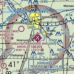
|
| Airport distance calculator |
|---|
|
|
| Sunrise and sunset |
|---|
|
Times for 14-Jul-2026
| | Local
(UTC-5) | | Zulu
(UTC) |
|---|
| Morning civil twilight | | 04:59 | | 09:59 |
| Sunrise | | 05:32 | | 10:32 |
| Sunset | | 20:22 | | 01:22 |
| Evening civil twilight | | 20:55 | | 01:55 |
|
| Current date and time |
|---|
| Zulu (UTC) | 14-Jul-2026 17:13:24 |
|---|
| Local (UTC-5) | 14-Jul-2026 12:13:24 |
|---|
|
| METAR |
|---|
| KIKK | 141655Z AUTO 29005KT 10SM CLR 31/22 A3020 RMK AO2 T03070215
|
|
| TAF |
|---|
KGYY
38nm NE | 141126Z 1412/1512 30005KT P6SM SKC FM141700 06007KT P6SM SKC FM150100 26003KT P6SM FEW250
|
KMDW
43nm N | 141459Z 1415/1518 31005KT P6SM SCT250 FM141800 10006KT P6SM FEW250 FM142300 26005KT P6SM SKC
|
|
| NOTAMs |
|---|
NOTAMs are issued by the DoD/FAA and will open in a separate window not controlled by AirNav.
|
|

