FAA INFORMATION EFFECTIVE 17 APRIL 2025
Location
| FAA Identifier: | JXN |
| Lat/Long: | 42-15-37.5950N 084-27-43.6990W
42-15.626583N 084-27.728317W
42.2604431,-84.4621386
(estimated) |
| Elevation: | 1000.8 ft. / 305.0 m (surveyed) |
| Variation: | 07W (2020) |
| From city: | 2 miles W of JACKSON, MI |
| Time zone: | UTC -4 (UTC -5 during Standard Time) |
| Zip code: | 49202 |
Airport Operations
| Airport use: | Open to the public |
| Activation date: | 04/1940 |
| Control tower: | yes |
| ARTCC: | CLEVELAND CENTER |
| FSS: | LANSING FLIGHT SERVICE STATION |
| NOTAMs facility: | JXN (NOTAM-D service available) |
| Attendance: | MON-FRI 0800-1700, ALL SAT-SUN 0800-1500 |
| Wind indicator: | lighted |
| Segmented circle: | yes |
| Lights: | WHEN ATCT CLSD ACTVT MALSR RWY 25; REIL RWY 07 & 32; PAPI RWY 07, 25, 14 & 32; HIRL RWY 07/25; MIRL RWY 14/32 - CTAF. |
| Beacon: | white-green (lighted land airport)
Operates sunset to sunrise. |
Airport Communications
| CTAF: | 128.475 |
| UNICOM: | 122.95 |
| ATIS: | 125.725 |
| WX ASOS: | PHONE 517-768-7506 |
| JACKSON GROUND: | 121.9 [0700-2100] |
| JACKSON TOWER: | 128.475 257.8 [0700-2100] |
| GREAT LAKES APPROACH: | 127.3 |
| GREAT LAKES DEPARTURE: | 127.3 |
| CLEARANCE DELIVERY: | 121.9 |
| EMERG: | 121.5 243.0 |
| WX AWOS-3P at TEW (18 nm N): | 119.425 (517-676-5607) |
- APCH/DEP SVC PRVDD BY CLEVELAND ARTCC (ZOB) ON FREQS 120.45/360.7 (LITCHFIELD RCAG) WHEN GREAT LAKES APCH CTL CLSD.
Nearby radio navigation aids
| VOR radial/distance | | VOR name | | Freq | | Var |
|---|
| SVMr260/39.5 | | SALEM VORTAC | | 114.30 | | 03W |
| NDB name | | Hdg/Dist | | Freq | | Var | | ID |
|---|
| TECUMSEH | | 304/29.0 | | 239 | | 06W | | TCU | - -.-. ..- |
| ADRIAN | | 330/29.0 | | 278 | | 06W | | ADG | .- -.. --. |
Airport Services
| Fuel available: | 100LL JET-A+
100LL:100LL & JET A+ AVBL SELF SVC ON MAIN RAMP. |
| Parking: | hangars and tiedowns |
| Airframe service: | MAJOR |
| Powerplant service: | MAJOR |
Runway Information
Runway 7/25
| Dimensions: | 5351 x 100 ft. / 1631 x 30 m |
| Surface: | asphalt/grooved, in excellent condition |
| Weight bearing capacity: | | PCN 30 /F/C/X/U | | Single wheel: | 76.0 | | Double wheel: | 100.0 | | Double tandem: | 180.0 |
|
| Runway edge lights: | high intensity |
| RUNWAY 7 | | RUNWAY 25 |
| Latitude: | 42-15.475683N | | 42-15.816708N |
| Longitude: | 084-28.265988W | | 084-27.172565W |
| Elevation: | 985.0 ft. | | 993.9 ft. |
| Traffic pattern: | left | | left |
| Runway heading: | 074 magnetic, 067 true | | 254 magnetic, 247 true |
| Markings: | precision, in good condition | | precision, in good condition |
| Visual slope indicator: | 4-light PAPI on left (3.00 degrees glide path) | | 4-light PAPI on left (3.00 degrees glide path) |
| Approach lights: | | | MALSR: 1,400 foot medium intensity approach lighting system with runway alignment indicator lights |
| Runway end identifier lights: | yes | | no |
| Touchdown point: | yes, no lights | | yes, no lights |
| Instrument approach: | | | ILS |
| Obstructions: | 72 ft. pline, 1613 ft. from runway, 660 ft. right of centerline, 19:1 slope to clear | | 94 ft. trees, 2758 ft. from runway, 773 ft. left of centerline, 27:1 slope to clear |
Runway 14/32
| Dimensions: | 4000 x 100 ft. / 1219 x 30 m |
| Surface: | asphalt/grooved, in good condition |
| Weight bearing capacity: | | PCN 16 /F/C/X/U | | Single wheel: | 42.0 | | Double wheel: | 62.0 | | Double tandem: | 115.0 |
|
| Runway edge lights: | medium intensity |
| RUNWAY 14 | | RUNWAY 32 |
| Latitude: | 42-15.826037N | | 42-15.374545N |
| Longitude: | 084-28.062978W | | 084-27.417795W |
| Elevation: | 972.1 ft. | | 1000.6 ft. |
| Traffic pattern: | left | | left |
| Runway heading: | 140 magnetic, 133 true | | 320 magnetic, 313 true |
| Markings: | nonprecision, in good condition | | nonprecision, in good condition |
| Visual slope indicator: | 4-light PAPI on left (3.00 degrees glide path) | | 4-light PAPI on left (3.50 degrees glide path) |
| Runway end identifier lights: | no | | yes |
| Touchdown point: | yes, no lights | | yes, no lights |
| Obstructions: | 10 ft. fence, 452 ft. from runway, 250 ft. left and right of centerline, 25:1 slope to clear | | none |
Airport Ownership and Management from official FAA records
| Ownership: | Publicly-owned |
| Owner: | JACKSON COUNTY
120 W MICHIGAN AVE, JACKSON CO TOWER BLDG 5TH FL
JACKSON, MI 49201-1338
Phone 517-788-4335 |
| Manager: | JUAN ZAPATA
3606 WILDWOOD AVE
JACKSON, MI 49202-1864
Phone 517-788-4225 |
Additional Remarks
| - | DEER & LRG BIRDS ON & INVOF ARPT. |
| - | LOW ALT HEL OPS PROHIBITED INVOF PRISON 4 MI NE. |
| - | WINTER FLD CONDS UNMON WHEN ATCT CLSD. |
| - | ACFT TAXIING UP TWY D COULD POSSLY MISS THE TURN FOR TWY A & VIOLATE THE SAFETY ZONE FOR RWY 07/25. |
| - | FOR CD WHEN ATCT CLSD CTC GREAT LAKES APCH AT 269-459-3345, WHEN APCH CLSD CTC CLEVELAND ARTCC AT 440-774-0224/0490. |
Instrument Procedures
NOTE: All procedures below are presented as PDF files. If you need a reader for these files, you should download the free Adobe Reader.NOT FOR NAVIGATION. Please procure official charts for flight.
FAA instrument procedures published for use from 17 April 2025 at 0901Z to 15 May 2025 at 0900z.
IAPs - Instrument Approach Procedures |
|---|
| ILS OR LOC RWY 25 | |
download (223KB) |
| RNAV (GPS) RWY 07 | |
download (224KB) |
| RNAV (GPS) RWY 14 | |
download (226KB) |
| RNAV (GPS) RWY 25 | |
download (229KB) |
| RNAV (GPS) RWY 32 | |
download (222KB) |
| NOTE: Special Alternate Minimums apply | |
download (139KB) |
| NOTE: Special Take-Off Minimums/Departure Procedures apply | |
download (349KB) |
Other nearby airports with instrument procedures:
KTEW - Mason Jewett Field Airport (18 nm N)
KJYM - Hillsdale Municipal Airport (21 nm S)
KRMY - Brooks Field Airport (22 nm W)
KFPK - Fitch H Beach Airport (24 nm NW)
KADG - Lenawee County Airport (29 nm SE)
|
|

Road maps at:
MapQuest
Bing
Google
| Aerial photo |
|---|
WARNING: Photo may not be current or correct
 Photo by Cindy Stammich
Taken in the Spring of 2022
looking north.
Photo by Cindy Stammich
Taken in the Spring of 2022
looking north.
Do you have a better or more recent aerial photo of Jackson County Airport/Reynolds Field that you would like to share? If so, please send us your photo.
|
| Sectional chart |
|---|
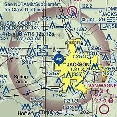
|
| Airport distance calculator |
|---|
|
|
| Sunrise and sunset |
|---|
|
Times for 21-Apr-2025
| | Local
(UTC-4) | | Zulu
(UTC) |
|---|
| Morning civil twilight | | 06:19 | | 10:19 |
| Sunrise | | 06:49 | | 10:49 |
| Sunset | | 20:25 | | 00:25 |
| Evening civil twilight | | 20:54 | | 00:54 |
|
| Current date and time |
|---|
| Zulu (UTC) | 22-Apr-2025 00:41:36 |
|---|
| Local (UTC-4) | 21-Apr-2025 20:41:36 |
|---|
|
| METAR |
|---|
| KJXN | 212356Z 25015G23KT 10SM OVC036 11/03 A2992 RMK AO2 PK WND 24029/2334 SLP135 T01060033 10178 20106 53017
|
KTEW
18nm N | 220015Z AUTO 26010G17KT 10SM OVC032 11/05 A2991 RMK AO2 T01060045
|
|
| TAF |
|---|
| KJXN | 211740Z 2118/2218 21023G32KT P6SM OVC030 FM212000 22021G29KT P6SM BKN025 FM212200 23019G29KT P6SM OVC035 FM220000 25011G23KT P6SM BKN035 FM221200 25006KT P6SM SCT250
|
|
| NOTAMs |
|---|
NOTAMs are issued by the DoD/FAA and will open in a separate window not controlled by AirNav.
|
|


