FAA INFORMATION EFFECTIVE 22 JANUARY 2026
Location
| FAA Identifier: | K19 |
| Lat/Long: | 40-15-43.9000N 094-20-20.5000W
40-15.731667N 094-20.341667W
40.2621944,-94.3390278
(estimated) |
| Elevation: | 891.3 ft. / 272 m (estimated) |
| Variation: | 05E (1985) |
| From city: | 1 mile N of ALBANY, MO |
| Time zone: | UTC -6 (UTC -5 during Daylight Saving Time) |
| Zip code: | 64402 |
Airport Operations
| Airport use: | Open to the public |
| Activation date: | 05/1982 |
| Control tower: | no |
| ARTCC: | KANSAS CITY CENTER |
| FSS: | COLUMBIA FLIGHT SERVICE STATION |
| NOTAMs facility: | COU (NOTAM-D service available) |
| Attendance: | UNATNDD |
| Wind indicator: | lighted |
| Segmented circle: | yes |
Airport Communications
Nearby radio navigation aids
| VOR radial/distance | | VOR name | | Freq | | Var |
|---|
| LMNr213/26.3 | | LAMONI VOR/DME | | 116.70 | | 07E |
| STJr048/32.4 | | ST JOSEPH VORTAC | | 115.50 | | 08E |
| NDB name | | Hdg/Dist | | Freq | | Var | | ID |
|---|
| AMAZON | | 045/34.6 | | 233 | | 04E | | AZN | .- --.. -. |
Airport Services
| Fuel available: | 100LL
100LL:SELF SERVICE FUEL - 24 HRS. |
Runway Information
Runway 1/19
| Dimensions: | 3300 x 50 ft. / 1006 x 15 m |
| Surface: | concrete, in good condition |
| Runway edge lights: | non-standard
RWY 01/19 VARIOUS THLD AND EDGE LGTS ARE BROKEN OR MISSING. |
| RUNWAY 1 | | RUNWAY 19 |
| Latitude: | 40-15.465333N | | 40-15.997667N |
| Longitude: | 094-20.413333W | | 094-20.268500W |
| Elevation: | 865.3 ft. | | 891.3 ft. |
| Traffic pattern: | left | | right |
| Markings: | basic, in fair condition | | basic, in fair condition |
| Visual slope indicator: | 2-light PAPI on left (3.00 degrees glide path) | | 2-light PAPI on left (3.00 degrees glide path) |
| Obstructions: | 44 ft. trees, 820 ft. from runway, 200 ft. left and right of centerline, 14:1 slope to clear
+3-15 FT BRUSH, POST, SMALL TREES, FARM ROAD, 95-200 FT FM RWY END, 80-125 FT R. | | 5 ft. fence, 245 ft. from runway, 125 ft. left and right of centerline, 9:1 slope to clear |
Airport Ownership and Management from official FAA records
| Ownership: | Publicly-owned |
| Owner: | CITY OF ALBANY
106 E CLAY
ALBANY, MO 64402
Phone 660-726-3935 |
| Manager: | DEREK BROWN
106 E. CLAY
ALBANY, MO 64402
Phone 660-726-3935
GROUNDS KEEPER. |
Additional Remarks
| - | WILDLIFE ON & INVOF ARPT. |
| - | FOR CD CTC KANSAS CITY ARTCC AT 913-254-8508. |
Instrument Procedures
There are no published instrument procedures at K19.
Some nearby airports with instrument procedures:
KEVU - Northwest Missouri Regional Airport (27 nm W)
KLWD - Lamoni Municipal Airport (30 nm NE)
KEZZ - Cameron Memorial Airport (32 nm S)
KTRX - Trenton Municipal Airport (36 nm E)
KSTJ - Rosecrans Memorial Airport (39 nm SW)
|
|

Road maps at:
MapQuest
Bing
Google
| Aerial photo |
|---|
WARNING: Photo may not be current or correct
 Photo taken 12-Aug-2008
Do you have a better or more recent aerial photo of Albany Municipal Airport that you would like to share? If so, please send us your photo.
|
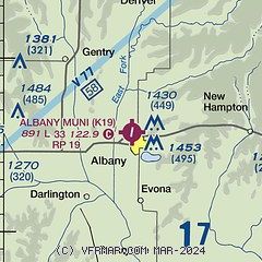
| Sectional chart |
|---|
|
| Airport distance calculator |
|---|
|
|
| Sunrise and sunset |
|---|
|
Times for 22-Jan-2026
| | Local
(UTC-6) | | Zulu
(UTC) |
|---|
| Morning civil twilight | | 07:06 | | 13:06 |
| Sunrise | | 07:35 | | 13:35 |
| Sunset | | 17:23 | | 23:23 |
| Evening civil twilight | | 17:52 | | 23:52 |
|
| Current date and time |
|---|
| Zulu (UTC) | 22-Jan-2026 17:20:42 |
|---|
| Local (UTC-6) | 22-Jan-2026 11:20:42 |
|---|
|
| METAR |
|---|
KEVU
27nm W | 221655Z AUTO 00000KT 10SM CLR 00/M10 A3030 RMK AO2 T00011098
|
KLWD
30nm NE | 221653Z AUTO 00000KT 10SM FEW060 BKN075 OVC085 M04/M13 A3030 RMK AO2 SLP279 T10391128
|
KEZZ
32nm S | 221655Z AUTO 24011KT 10SM CLR 01/M11 A3036 RMK AO2
|
KSTJ
40nm SW | 221653Z 00000KT 10SM CLR M01/M11 A3034 RMK AO2 SLP287 T10111106
|
KICL
41nm NW | 221655Z AUTO 04005KT 10SM OVC070 M04/M10 A3034 RMK AO2
|
KCDJ
44nm SE | 221651Z AUTO 25006KT 00/M11 A3035 RMK AO1 SLP292 T00001106
|
KCSQ
45nm N | 221655Z AUTO 31005KT 10SM BKN060 OVC070 M05/M13 A3029 RMK AO2
|
|
| TAF |
|---|
KSTJ
40nm SW | 221139Z 2212/2312 VRB03KT P6SM BKN100 FM221700 26007KT P6SM FEW240 FM230000 36005KT P6SM SCT220 FM230800 01011G20KT P6SM BKN200
|
|
| NOTAMs |
|---|
NOTAMs are issued by the DoD/FAA and will open in a separate window not controlled by AirNav.
|
|

