FAA INFORMATION EFFECTIVE 22 JANUARY 2026
Location
| FAA Identifier: | K30 |
| Lat/Long: | 43-11-00.2660N 073-37-59.4200W
43-11.004433N 073-37.990333W
43.1834072,-73.6331722
(estimated) |
| Elevation: | 230 ft. / 70 m (estimated) |
| Variation: | 14W (1985) |
| From city: | 2 miles SE of GANSEVOORT, NY |
| Time zone: | UTC -5 (UTC -4 during Daylight Saving Time) |
| Zip code: | 12831 |
Airport Operations
| Airport use: | Open to the public |
| Activation date: | 11/1990 |
| Control tower: | no |
| ARTCC: | BOSTON CENTER |
| FSS: | BURLINGTON FLIGHT SERVICE STATION |
| NOTAMs facility: | BTV (NOTAM-D service available) |
| Attendance: | UNATNDD |
| Wind indicator: | yes |
| Segmented circle: | yes |
| Lights: | ACTVT MIRL RY 06/24 - CTAF. |
Airport Communications
| CTAF: | 122.9 |
| WX ASOS at GFL (10 nm N): | 119.925 (518-743-1728) |
| WX AWOS-3 at 5B2 (13 nm SW): | 132.025 (518-884-9289) |
Nearby radio navigation aids
| VOR radial/distance | | VOR name | | Freq | | Var |
|---|
| CAMr326/17.0 | | CAMBRIDGE VOR/DME | | 115.00 | | 14W |
| ALBr029/27.2 | | ALBANY VORTAC | | 115.30 | | 13W |
| NDB name | | Hdg/Dist | | Freq | | Var | | ID |
|---|
| GANSE | | 210/4.5 | | 209 | | 14W | | GF | --. ..-. |
| HUNTER | | 048/23.7 | | 356 | | 14W | | HEU | .... . ..- |
| JOHNSTOWN | | 084/32.5 | | 523 | | 14W | | JJH | .--- .--- .... |
Airport Services
| Parking: | hangars and tiedowns |
Runway Information
Runway 6/24
| Dimensions: | 2200 x 24 ft. / 671 x 7 m |
| Surface: | asphalt, in good condition
LIGHT COLORED FULL WIDTH CONCRETE PAVEMENT SECTION 144' FROM RY 24 THRESHOLD, 20' LONG. |
| Runway edge lights: | non-standard
RY 06/24 NSTD MIRL DUE TO SPACING, 33 FT FM RY EDGE ON 3 FT WOOD POSTS. |
| Runway edge markings: | 06/24 NSTD DSPLCD THLD; NO BAR. |
| RUNWAY 6 | | RUNWAY 24 |
| Traffic pattern: | right | | left |
| Displaced threshold: | 200 ft. | | no |
| Markings: | NSTD, in fair condition | | NSTD, in fair condition |
| Obstructions: | 103 ft. road, 392 ft. from runway, 105 ft. left of centerline, 1:1 slope to clear
RWY 06 HAS +15 FT ROAD AND 4 FT FENCE, 0 - 200 FT FM RWY END, 46 FT RIGHT & ACRS EXTD RWY CNTRLN; +20 FT HOUSE, 75 FT FM RWY END, 100 FT RIGHT. | | 70 ft. tree, 1047 ft. from runway, 90 ft. left of centerline, 12:1 slope to clear
RWY 24 HAS BRUSH / TREES BOTH SIDES OF RWY. |
Airport Ownership and Management from official FAA records
| Ownership: | Privately-owned |
| Owner: | HEBER AIRPARK INC
288 BROWNVILLE RD
GANSEVOORT, NY 12831
Phone 518-793-8983 |
| Manager: | JAMES HEBER
286 BROWNVILLE RD
GANSEVOORT, NY 12831
Phone 518-793-8983 |
Additional Remarks
| - | BIRDS & WILDLIFE ON & INVOF ARPT. |
| - | GOLF COURSE ADJ TO RY BOTH SIDES. |
| - | RY 24 UPHILL GRADE EXCEEDS 2% UP. RECOMMENDED LDG RY 24, TKOF RY 06. |
| - | 25 FT DROPOFF 10 FT FM RY 24 THLD. |
| - | SKYDIVING ON & INVOF ARPT MAY THRU OCT. |
| - | FOR CD CTC ALBANY APCH AT 518-862-2299. |
Instrument Procedures
There are no published instrument procedures at K30.
Some nearby airports with instrument procedures:
KGFL - Floyd Bennett Memorial Airport (10 nm N)
5B2 - Saratoga County Airport (13 nm SW)
KSCH - Schenectady County Airport (24 nm SW)
KDDH - William H Morse State Airport (24 nm SE)
KALB - Albany International Airport (27 nm S)
|
|

Road maps at:
MapQuest
Bing
Google
| Aerial photo |
|---|
WARNING: Photo may not be current or correct

Do you have a better or more recent aerial photo of Heber Airpark that you would like to share? If so, please send us your photo.
|
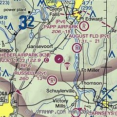
| Sectional chart |
|---|
|
| Airport distance calculator |
|---|
|
|
| Sunrise and sunset |
|---|
|
Times for 14-Feb-2026
| | Local
(UTC-5) | | Zulu
(UTC) |
|---|
| Morning civil twilight | | 06:26 | | 11:26 |
| Sunrise | | 06:55 | | 11:55 |
| Sunset | | 17:23 | | 22:23 |
| Evening civil twilight | | 17:52 | | 22:52 |
|
| Current date and time |
|---|
| Zulu (UTC) | 14-Feb-2026 16:05:40 |
|---|
| Local (UTC-5) | 14-Feb-2026 11:05:40 |
|---|
|
| METAR |
|---|
KGFL
9nm N | 141553Z AUTO 16003KT 10SM OVC055 M04/M09 A3002 RMK AO2 SLP177 T10441089
|
|
| TAF |
|---|
KGFL
9nm N | 141156Z 1412/1512 20005KT P6SM SCT015 OVC022 PROB30 1413/1417 4SM -SHSN OVC015 FM142000 20005KT P6SM OVC035 FM142200 30005KT P6SM OVC040 FM150600 36003KT P6SM BKN050
|
|
| NOTAMs |
|---|
NOTAMs are issued by the DoD/FAA and will open in a separate window not controlled by AirNav.
|
|

