FAA INFORMATION EFFECTIVE 09 JULY 2026
Location
| FAA Identifier: | 5B2 |
| Lat/Long: | 43-03-02.6000N 073-51-41.9000W
43-03.043333N 073-51.698333W
43.0507222,-73.8616389
(estimated) |
| Elevation: | 433.9 ft. / 132.3 m (surveyed) |
| Variation: | 14W (1995) |
| From city: | 3 miles SW of SARATOGA SPRINGS, NY |
| Time zone: | UTC -4 (UTC -5 during Standard Time) |
| Zip code: | 12020 |
Airport Operations
| Airport use: | Open to the public |
| Activation date: | 08/1943 |
| Control tower: | no |
| ARTCC: | BOSTON CENTER |
| FSS: | BURLINGTON FLIGHT SERVICE STATION |
| NOTAMs facility: | 5B2 (NOTAM-D service available) |
| Attendance: | 0730-DUSK |
| Pattern altitude: | 1200.9 ft. MSL |
| Wind indicator: | yes |
| Segmented circle: | no |
| Lights: | ACTVT REIL RWY 05/23; MIRL RWY 05/23 - CTAF. |
| Beacon: | white-green (lighted land airport)
Operates sunset to sunrise. |
| International operations: | customs landing rights airport |
Airport Communications
| CTAF/UNICOM: | 123.075 |
| WX AWOS-3: | 132.025 (518-884-9289) |
| ALBANY APPROACH: | 118.05 |
| ALBANY DEPARTURE: | 118.05 |
| WX AWOS-3 at SCH (12 nm S): | 119.275 (518-399-6586) |
| WX ASOS at ALB (18 nm S): | 120.45 (518-218-6284) |
Nearby radio navigation aids
| VOR radial/distance | | VOR name | | Freq | | Var |
|---|
| ALBr005/18.4 | | ALBANY VORTAC | | 115.30 | | 13W |
| CAMr292/23.0 | | CAMBRIDGE VOR/DME | | 115.00 | | 14W |
| NDB name | | Hdg/Dist | | Freq | | Var | | ID |
|---|
| HUNTER | | 029/12.2 | | 356 | | 14W | | HEU | .... . ..- |
| JOHNSTOWN | | 096/20.8 | | 523 | | 14W | | JJH | .--- .--- .... |
Airport Services
| Fuel available: | 100LL JET-A |
| Parking: | hangars and tiedowns |
| Airframe service: | MAJOR |
| Powerplant service: | MAJOR |
| Bottled oxygen: | LOW |
| Bulk oxygen: | NONE |
Runway Information
Runway 5/23
| Dimensions: | 4699 x 100 ft. / 1432 x 30 m |
| Surface: | asphalt/concrete/grooved, in good condition |
| Weight bearing capacity: | | PCN 46 /F/A/X/T | | Single wheel: | 116.0 | | Double wheel: | 192.0 |
|
| Runway edge lights: | medium intensity |
| RUNWAY 5 | | RUNWAY 23 |
| Latitude: | 43-02.725627N | | 43-03.330943N |
| Longitude: | 073-52.041803W | | 073-51.384960W |
| Elevation: | 433.9 ft. | | 427.0 ft. |
| Traffic pattern: | left | | left |
| Runway heading: | 053 magnetic, 039 true | | 233 magnetic, 219 true |
| Markings: | nonprecision, in good condition | | nonprecision, in good condition |
| Visual slope indicator: | | | 2-light PAPI on left (3.00 degrees glide path) |
| Runway end identifier lights: | yes | | yes |
| Touchdown point: | yes, no lights | | yes, no lights |
| Obstructions: | 89 ft. trees, 1579 ft. from runway, 194 ft. right of centerline, 15:1 slope to clear | | 89 ft. trees, 1876 ft. from runway, 88 ft. right of centerline, 18:1 slope to clear |
Runway 14/32
| Dimensions: | 4000 x 100 ft. / 1219 x 30 m |
| Surface: | asphalt/concrete, in good condition |
| Weight bearing capacity: | | PCN 30 /F/A/X/T | | Single wheel: | 83.0 | | Double wheel: | 126.0 |
|
| Runway edge lights: | medium intensity
RY LIGHTS OTS. |
| RUNWAY 14 | | RUNWAY 32 |
| Latitude: | 43-03.265625N | | 43-02.855512N |
| Longitude: | 073-52.029923W | | 073-51.327443W |
| Elevation: | 431.8 ft. | | 425.8 ft. |
| Traffic pattern: | left | | left |
| Runway heading: | 143 magnetic, 129 true | | 323 magnetic, 309 true |
| Markings: | nonprecision, in fair condition | | nonprecision, in good condition |
| Runway end identifier lights: | | | no |
| Touchdown point: | yes, no lights | | yes, no lights |
| Obstructions: | 69 ft. trees, 455 ft. from runway, 222 ft. right of centerline, 3:1 slope to clear | | 73 ft. trees, 713 ft. from runway, 72 ft. right of centerline, 7:1 slope to clear
PAVED SVC ROAD 186 FT LEFT OF CTRLN, ALONG RWY TO TXY C. |
Airport Ownership and Management from official FAA records
| Ownership: | Publicly-owned |
| Owner: | SARATOGA COUNTY
3654 GALWAY RD
BALLSTON SPA, NY 12020
Phone 518-885-2235
GREG BALL, SARATOGA CO DPW. |
| Manager: | JON ZILKA
405 GREENFIELD AVE.
BALLSTON SPA, NY 12020
Phone 518-885-5470
FBO |
Additional Remarks
| A104 | PEAK DURING RACING SEASON. |
| - | JET OR TURBINE ACFT USE 5 OR 23. |
| - | GLIDER ACTVTY ON WKENDS & OCNLY WKDAYS WITH EXTENSIVE PRE-LAUNCH & AFTER LDG GND OPNS ON SHOULDERS OF RY IN USE. |
| - | ALBANY ANG HELS DO TGL OPNS USUALLY DURG DALGT HRS. |
| - | YEAR ROUND FEDERALLY & STATE PROTECTED HABITAT FOR KARNER BLUE BUTTERFLY; UNAUTHORIZED OFF-PAVEMENT OPNS PROHIBITED. |
| - | GCO AVBL ON FREQ 118.125 THRU ALB CLEARANCE DELIVERY. |
| - | FOR CD IF GCO UNA CTC ALBANY APCH AT 518-862-2299. |
Instrument Procedures
NOTE: All procedures below are presented as PDF files. If you need a reader for these files, you should download the free Adobe Reader.NOT FOR NAVIGATION. Please procure official charts for flight.
FAA instrument procedures published for use from 09 July 2026 at 0901Z to 06 August 2026 at 0900Z.
IAPs - Instrument Approach Procedures |
|---|
| RNAV (GPS) RWY 05 | |
download (237KB) |
| RNAV (GPS) RWY 23 | |
download (293KB) |
| NOTE: Special Take-Off Minimums/Departure Procedures apply | |
download (150KB) |
Other nearby airports with instrument procedures:
KSCH - Schenectady County Airport (12 nm S)
KALB - Albany International Airport (18 nm S)
KGFL - Floyd Bennett Memorial Airport (21 nm NE)
NY0 - Fulton County Airport (21 nm W)
KDDH - William H Morse State Airport (29 nm E)
|
|

Road maps at:
MapQuest
Bing
Google
| Aerial photo |
|---|
WARNING: Photo may not be current or correct
 Photo by Nick Tognacci
Photo taken 03-Oct-2013
looking south at 7500'.
Photo by Nick Tognacci
Photo taken 03-Oct-2013
looking south at 7500'.
Do you have a better or more recent aerial photo of Saratoga County Airport that you would like to share? If so, please send us your photo.
|
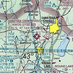
| Sectional chart |
|---|
|
CAUTION: Diagram may not be current

| Airport distance calculator |
|---|
|
|
| Sunrise and sunset |
|---|
|
Times for 20-Jul-2026
| | Local
(UTC-4) | | Zulu
(UTC) |
|---|
| Morning civil twilight | | 05:02 | | 09:02 |
| Sunrise | | 05:35 | | 09:35 |
| Sunset | | 20:28 | | 00:28 |
| Evening civil twilight | | 21:02 | | 01:02 |
|
| Current date and time |
|---|
| Zulu (UTC) | 20-Jul-2026 08:32:59 |
|---|
| Local (UTC-4) | 20-Jul-2026 04:32:59 |
|---|
|
| METAR |
|---|
KSCH
12nm S | 200049Z 30010KT 10SM CLR 21/10 A2990 RMK LAST
|
KALB
18nm S | 200751Z 00000KT 10SM FEW250 14/10 A2995 RMK AO2 SLP140 T01440100 $
|
KGFL
20nm NE | 200753Z AUTO 00000KT 10SM CLR 10/09 A2994 RMK AO2 SLP139 T01000089 $
|
KNY0
21nm W | 200815Z AUTO 24004KT 10SM CLR 11/11 A2997 RMK AO2 T01090105
|
|
| TAF |
|---|
KALB
18nm S | 200520Z 2006/2106 VRB04KT P6SM FEW250 FM201500 18007KT P6SM SCT060 FM210000 17006KT P6SM FEW060 BKN250
|
KGFL
20nm NE | 200558Z 2006/2106 VRB03KT P6SM FEW060 FEW250 TEMPO 2008/2010 6SM BR FM201500 19008KT P6SM SCT060 FM210000 18004KT P6SM FEW060 BKN250
|
|
| NOTAMs |
|---|
NOTAMs are issued by the DoD/FAA and will open in a separate window not controlled by AirNav.
|
|


