FAA INFORMATION EFFECTIVE 16 APRIL 2026
Location
| FAA Identifier: | ALB |
| Lat/Long: | 42-44-56.8180N 073-48-07.1280W
42-44.946967N 073-48.118800W
42.7491161,-73.8019800
(estimated) |
| Elevation: | 284.8 ft. / 86.8 m (surveyed) |
| Variation: | 13W (1980) |
| From city: | 6 miles NW of ALBANY, NY |
| Time zone: | UTC -4 (UTC -5 during Standard Time) |
| Zip code: | 12110 |
Airport Operations
| Airport use: | Open to the public |
| Activation date: | 03/1941 |
| Control tower: | yes |
| ARTCC: | BOSTON CENTER |
| FSS: | BURLINGTON FLIGHT SERVICE STATION |
| NOTAMs facility: | ALB (NOTAM-D service available) |
| Attendance: | CONTINUOUS |
| Wind indicator: | lighted |
| Segmented circle: | no |
| Lights: | SS-SR |
| Beacon: | white-green (lighted land airport)
Operates sunset to sunrise. |
| Landing fee: | yes |
| Fire and rescue: | ARFF index C |
| International operations: | international airport of entry |
Airport Communications
| UNICOM: | 122.95 |
| WX ASOS: | 120.45 (518-218-6284) |
| ALBANY GROUND: | 121.7 348.6 |
| ALBANY TOWER: | 119.5 257.8 |
| ALBANY APPROACH: | 118.05 ;194-011 132.825 ;011-194 263.075 ;194-011 307.2 ;011-194 118.05 127.15 |
| ALBANY DEPARTURE: | 118.05 ;194-011 132.825 ;011-194 263.075 ;194-011 307.2 ;011-194 118.05 127.15 |
| CLEARANCE DELIVERY: | 127.5 |
| CLASS C: | 118.05 ;194-011 132.825 ;011-194 263.075 ;194-011 307.2 ;011-194 |
| D-ATIS: | 120.45 |
| EMERG: | 121.5 243.0 |
| IC: | 132.825 ;011-194 307.2 ;011-194 |
| NG OPS: | 122.775 258.2 30.1FM |
| WX AWOS-3 at SCH (8 nm NW): | 119.275 (518-399-6586) |
| WX AWOS-3 at 5B2 (18 nm N): | 132.025 (518-884-9289) |
Nearby radio navigation aids
| VOR radial/distance | | VOR name | | Freq | | Var |
|---|
| ALB at field | | ALBANY VORTAC | | 115.30 | | 13W |
| CAMr248/24.9 | | CAMBRIDGE VOR/DME | | 115.00 | | 14W |
| NDB name | | Hdg/Dist | | Freq | | Var | | ID |
|---|
| HUNTER | | 151/8.6 | | 356 | | 14W | | HEU | .... . ..- |
| JOHNSTOWN | | 137/27.7 | | 523 | | 14W | | JJH | .--- .--- .... |
Airport Services
| Fuel available: | 100LL JET-A |
| Parking: | hangars and tiedowns |
| Airframe service: | MAJOR |
| Powerplant service: | MAJOR |
| Bottled oxygen: | HIGH |
Runway Information
Runway 1/19
| Dimensions: | 8500 x 150 ft. / 2591 x 46 m |
| Surface: | asphalt/grooved, in good condition |
| Weight bearing capacity: | | Single wheel: | 140.0 | | Double wheel: | 200.0 | | Double tandem: | 400.0 |
|
| Runway edge lights: | high intensity |
| RUNWAY 1 | | RUNWAY 19 |
| Latitude: | 42-44.229967N | | 42-45.628557N |
| Longitude: | 073-48.255418W | | 073-48.315913W |
| Elevation: | 284.3 ft. | | 279.4 ft. |
| Traffic pattern: | left | | left |
| Runway heading: | 011 magnetic, 358 true | | 191 magnetic, 178 true |
| Declared distances: | TORA:8500 TODA:8500 ASDA:8500 LDA:8500 | | TORA:8500 TODA:8500 ASDA:8500 LDA:8500 |
| Markings: | precision, in good condition | | precision, in good condition |
| Visual slope indicator: | 4-light PAPI on right (3.00 degrees glide path) | | 4-light PAPI on left (3.00 degrees glide path) |
| RVR equipment: | touchdown, rollout | | touchdown, rollout |
| Approach lights: | MALSR: 1,400 foot medium intensity approach lighting system with runway alignment indicator lights | | MALSR: 1,400 foot medium intensity approach lighting system with runway alignment indicator lights |
| Runway end identifier lights: | | | no |
| Centerline lights: | yes | | yes |
| Touchdown point: | yes, lighted | | yes, no lights |
| Instrument approach: | ILS/DME | | ILS/DME |
| Obstructions: | none | | 80 ft. tree, 2040 ft. from runway, 75 ft. left of centerline, 23:1 slope to clear |
Runway 10/28
| Dimensions: | 7200 x 150 ft. / 2195 x 46 m |
| Surface: | asphalt/grooved, in good condition |
| Weight bearing capacity: | | Single wheel: | 140.0 | | Double wheel: | 200.0 | | Double tandem: | 400.0 |
|
| Runway edge lights: | high intensity |
| RUNWAY 10 | | RUNWAY 28 |
| Latitude: | 42-44.949023N | | 42-44.986612N |
| Longitude: | 073-48.725483W | | 073-47.118093W |
| Elevation: | 276.4 ft. | | 276.0 ft. |
| Traffic pattern: | left | | left |
| Runway heading: | 101 magnetic, 088 true | | 281 magnetic, 268 true |
| Displaced threshold: | no | | 1192 ft. |
| Declared distances: | TORA:7200 TODA:7200 ASDA:6780 LDA:6780 | | TORA:7200 TODA:7200 ASDA:7200 LDA:6007 |
| Markings: | nonprecision, in good condition | | nonprecision, in good condition |
| Visual slope indicator: | | | 4-light PAPI on left (3.22 degrees glide path) |
| Runway end identifier lights: | yes | | yes |
| Centerline lights: | yes | | yes |
| Touchdown point: | yes, no lights | | yes, no lights |
| Obstructions: | 151 ft. gnd, 5009 ft. from runway, 84 ft. left of centerline, 31:1 slope to clear
RWY 28 APCH RATIO 26:1 TO DTHR. | | 54 ft. tree, 1019 ft. from runway, 162 ft. left of centerline, 15:1 slope to clear |
Airport Ownership and Management from official FAA records
| Ownership: | Publicly-owned |
| Owner: | ALBANY COUNTY ARPT AUTH
737 ALBANY SHAKER RD
ALBANY, NY 12211
Phone 518-242-2200
LEASEE. PROPERTY OWNED BY ALBANY CO, 112 STATE ST, ALBANY, NY 12207; FONE 518-447-7000. |
| Manager: | RAMON CAMILLI
737 ALBANY SHAKER RD
ALBANY, NY 12211
Phone 518-242-2384 |
Additional Remarks
| A39-01/19 | PCR VALUE: 508/F/D/X/T |
| A39-10/28 | PCR VALUE: 266/F/D/X/T |
| - | MOWING WI SAFETY AREAS OF ALL RWYS & TWYS MAY-NOV. |
| - | NO ACFT PRKG BTN FIRE STN & TWY L. |
| - | TWY D EAST OF RWY 01/19 RSTRD TO ACFT 12500 LBS & LESS. |
| - | BIRDS, DEER & OTHER WILDLIFE ON & INVOF ARPT. |
| - | WX BALLOON LAUNCHES APRXLY 3 MI S OF ARPT AT 0600 & 1800. |
| - | TWY C WEST OF TWY A: NON MOV AREA. |
| - | CUST/IMG FLT INFO SVC FAC LCTD N END GA APN. ACFT CLRG CUST USE PAINTED PSN MKGS & PROCD TO MINIMIZE BLAST IMPACT. |
Instrument Procedures
NOTE: All procedures below are presented as PDF files. If you need a reader for these files, you should download the free Adobe Reader.NOT FOR NAVIGATION. Please procure official charts for flight.
FAA instrument procedures published for use from 16 April 2026 at 0901Z to 14 May 2026 at 0900Z.
IAPs - Instrument Approach Procedures |
|---|
| ILS OR LOC RWY 01 | |
download (251KB) |
| ILS OR LOC RWY 19 | |
download (270KB) |
| ILS RWY 01 (SA CAT II) | |
download (237KB) |
| RNAV (RNP) Z RWY 01 | |
download (239KB) |
| RNAV (RNP) Z RWY 19 | |
download (236KB) |
| RNAV (GPS) RWY 10 | |
download (201KB) |
| RNAV (GPS) RWY 28 | |
download (251KB) |
| RNAV (GPS) Y RWY 01 | |
download (230KB) |
| RNAV (GPS) Y RWY 19 | |
download (241KB) |
| VOR RWY 28 | |
download (211KB) |
| NOTE: Special Alternate Minimums apply | |
download (144KB) |
Departure Procedures |
|---|
| ALBANY SEVEN | |
2 pages:
[1] [2] (241KB) |
| NOTE: Special Take-Off Minimums/Departure Procedures apply | |
download (443KB) |
Other nearby airports with instrument procedures:
KSCH - Schenectady County Airport (8 nm NW)
4B0 - South Albany Airport (11 nm S)
5B2 - Saratoga County Airport (18 nm N)
KDDH - William H Morse State Airport (26 nm E)
NY0 - Fulton County Airport (28 nm NW)
|
|

Road maps at:
MapQuest
Bing
Google
| Aerial photo |
|---|
WARNING: Photo may not be current or correct
 Photo by Marawan Bakir of Schenectady, NY
Photo taken 07-Sep-2014
looking southwest.
Photo by Marawan Bakir of Schenectady, NY
Photo taken 07-Sep-2014
looking southwest.
Do you have a better or more recent aerial photo of Albany International Airport that you would like to share? If so, please send us your photo.
|
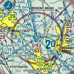
| Sectional chart |
|---|
|
CAUTION: Diagram may not be current
 Download PDF
of official airport diagram from the FAA
| Airport distance calculator |
|---|
|
|
| Sunrise and sunset |
|---|
|
Times for 22-Apr-2026
| | Local
(UTC-4) | | Zulu
(UTC) |
|---|
| Morning civil twilight | | 05:34 | | 09:34 |
| Sunrise | | 06:04 | | 10:04 |
| Sunset | | 19:44 | | 23:44 |
| Evening civil twilight | | 20:14 | | 00:14 |
|
| Current date and time |
|---|
| Zulu (UTC) | 22-Apr-2026 14:53:28 |
|---|
| Local (UTC-4) | 22-Apr-2026 10:53:28 |
|---|
|
| METAR |
|---|
| KALB | 221351Z 16014G21KT 10SM BKN018 OVC060 07/03 A3007 RMK AO2 SLP183 T00720033
|
KSCH
8nm NW | 220145Z 00000KT 10SM OVC100 07/M09 A3018 RMK LAST
|
|
| TAF |
|---|
| KALB | 221136Z 2212/2312 16010G17KT P6SM VCSH BKN060 OVC080 TEMPO 2212/2214 P6SM BKN015 OVC025 FM221400 16011G22KT P6SM BKN018 OVC035 FM230200 16008KT P6SM OVC013 FM230800 VRB03KT P6SM BCFG FEW003 BKN007
|
|
| NOTAMs |
|---|
NOTAMs are issued by the DoD/FAA and will open in a separate window not controlled by AirNav.
|
|


