FAA INFORMATION EFFECTIVE 14 MAY 2026
Location
| FAA Identifier: | SCH |
| Lat/Long: | 42-51-09.7860N 073-55-46.4320W
42-51.163100N 073-55.773867W
42.8527183,-73.9295644
(estimated) |
| Elevation: | 377.9 ft. / 115.2 m (surveyed) |
| Variation: | 14W (2000) |
| From city: | 3 miles N of SCHENECTADY, NY |
| Time zone: | UTC -4 (UTC -5 during Standard Time) |
| Zip code: | 12302 |
Airport Operations
| Airport use: | Open to the public |
| Activation date: | 01/1940 |
| Control tower: | yes |
| ARTCC: | BOSTON CENTER |
| FSS: | BURLINGTON FLIGHT SERVICE STATION |
| NOTAMs facility: | SCH (NOTAM-D service available) |
| Attendance: | 0730-2230 |
| Wind indicator: | lighted |
| Segmented circle: | no |
| Lights: | WHEN ATCT CLSD, ACTVT MALSR RWY 04; PAPI RWY 04, 10, 22 & 28; HIRL RWY 04/22; MIRL RWY 10/28 - CTAF. |
| Beacon: | white-green (lighted land airport)
Operates sunset to sunrise. |
| Landing fee: | yes |
| International operations: | customs landing rights airport |
Airport Communications
| CTAF: | 121.3 |
| UNICOM: | 122.95 |
| WX AWOS-3: | 119.275 (518-399-6586) |
| SCHENECTADY GROUND: | 121.9 [0730-2230 MON-FRI; 0730-2100 WKNDS AND HOLS; CLSD THANKSGIVING & CHRISTMAS; OTR TIMES BY NOTAM.] |
| SCHENECTADY TOWER: | 121.3 321.1 257.8R 291.6R 307.2R 343.7R 352.0R 378.8R [0730-2230 MON-FRI; 0730-2100 WKNDS AND HOLS; CLSD THANKSGIVING & CHRISTMAS; OTR TIMES BY NOTAM.] |
| ALBANY APPROACH: | 132.825 |
| ALBANY DEPARTURE: | 132.825 |
| ANG OPS: | 340.8 |
| EMERG: | 121.5 243.0 |
| WX ASOS at ALB (8 nm SE): | 120.45 (518-218-6284) |
| WX AWOS-3 at 5B2 (12 nm N): | 132.025 (518-884-9289) |
| WX AWOS-3 at NY0 (20 nm NW): | 119.225 (518-762-0322) |
- USE 122.95 FOR SVC FM FBO
Nearby radio navigation aids
| VOR radial/distance | | VOR name | | Freq | | Var |
|---|
| ALBr332/8.4 | | ALBANY VORTAC | | 115.30 | | 13W |
| CAMr266/27.1 | | CAMBRIDGE VOR/DME | | 115.00 | | 14W |
| NDB name | | Hdg/Dist | | Freq | | Var | | ID |
|---|
| HUNTER | | at field | | 356 | | 14W | | HEU | .... . ..- |
| JOHNSTOWN | | 130/19.7 | | 523 | | 14W | | JJH | .--- .--- .... |
Airport Services
| Fuel available: | 100LL JET-A |
| Parking: | hangars and tiedowns |
| Airframe service: | MINOR |
| Powerplant service: | MAJOR |
| Bottled oxygen: | NONE |
| Bulk oxygen: | LOW |
Runway Information
Runway 4/22
| Dimensions: | 7001 x 150 ft. / 2134 x 46 m |
| Surface: | asphalt/grooved, in excellent condition |
| Weight bearing capacity: | | PCN 62 /R/B/W/T | | Single wheel: | 95.0 | | Double wheel: | 175.0 | | Double tandem: | 348.0 | | Dual double tandem: | 850.0 |
|
| Runway edge lights: | high intensity |
| RUNWAY 4 | | RUNWAY 22 |
| Latitude: | 42-50.813828N | | 42-51.849773N |
| Longitude: | 073-56.027778W | | 073-55.341365W |
| Elevation: | 318.4 ft. | | 377.9 ft. |
| Traffic pattern: | left | | left |
| Runway heading: | 040 magnetic, 026 true | | 220 magnetic, 206 true |
| Markings: | precision, in good condition | | nonprecision, in good condition |
| Visual slope indicator: | 4-light PAPI on left (3.00 degrees glide path) | | 4-light PAPI on left (3.00 degrees glide path) |
| Approach lights: | MALSR: 1,400 foot medium intensity approach lighting system with runway alignment indicator lights | | |
| Runway end identifier lights: | no | | no |
| Touchdown point: | yes, no lights | | yes, no lights |
| Instrument approach: | ILS | | |
| Obstructions: | 48 ft. trees, 1086 ft. from runway, 533 ft. right of centerline, 18:1 slope to clear | | 22 ft. gnd, 200 ft. from runway, 500 ft. right of centerline, 1:1 slope to clear
RWY 22 +22FT RISING TERRAIN, 500 FT RT, 0 - 200 FT FM RWY. |
Runway 10/28
| Dimensions: | 4850 x 150 ft. / 1478 x 46 m |
| Surface: | asphalt/grooved, in good condition |
| Weight bearing capacity: | | PCN 48 /F/B/Y/T | | Single wheel: | 55.0 | | Double wheel: | 134.0 | | Double tandem: | 218.0 | | Dual double tandem: | 541.0 |
|
| Runway edge lights: | medium intensity |
| RUNWAY 10 | | RUNWAY 28 |
| Latitude: | 42-50.905012N | | 42-50.934135N |
| Longitude: | 073-56.444858W | | 073-55.360470W |
| Elevation: | 324.8 ft. | | 319.9 ft. |
| Traffic pattern: | left | | left |
| Runway heading: | 102 magnetic, 088 true | | 282 magnetic, 268 true |
| Displaced threshold: | 200 ft. | | no |
| Markings: | nonprecision, in good condition | | nonprecision, in good condition |
| Visual slope indicator: | 2-light PAPI on left (4.00 degrees glide path) | | 2-light PAPI on left (3.00 degrees glide path) |
| Runway end identifier lights: | no | | yes |
| Touchdown point: | yes, no lights | | yes, no lights |
| Obstructions: | 32 ft. pole, 520 ft. from runway, 241 ft. left of centerline, 10:1 slope to clear
RWY 10 CLNC SLOPE 14:1 TO DTHR DUE TO 87 FT TREE, 1223 FT FM DTHR, 190 FT RT. | | 19 ft. trees, 200 ft. from runway, 230 ft. right of centerline
RWY 28 +10 FT ROAD, 150 FT - 200 FT FM RWY, 220 FT RT. |
Airport Ownership and Management from official FAA records
| Ownership: | Publicly-owned |
| Owner: | SCHENECTADY COUNTY
COUNTY OFFICE BLDG
SCHENECTADY, NY 12305-2114
Phone 518-356-5344 |
| Manager: | SCOTT BARBER
21 TOWER ROAD
SCOTIA, NY 12302-3487
Phone (518) 399-0111 |
Additional Remarks
| - | LANDING FEE FOR INTINRNT MULTI-ENGINE ACFT REQUESTING TWR SVC 0330Z-1230Z. |
| - | MILITARY: ANG APRON: ORANGE DASHED WINGTIP CLNC LINES BOTH SIDES OF YELLOW CENTER TAXILINE. DASHED WINGTIP LINES PROVIDE POSITIVE, CLEARLY IDENTIFIABLE OBST CLNC FOR TAXIING ACFT. ANY OBJECT PARKED ON BACK SIDE OF LINES PROVIDE NO WINGTIP CLNC ISSUE. |
| - | NO ULTRA-LIGHT OPERATONS IN CLASS D AIRSPACE WITHOUT APPROV FM ATCT. |
| - | FLT NOTIFICATION SVC (ADCUS) AVBL. |
| - | FUEL: A++ (MIL). |
| - | FOR CD CTC ALBANY APCH AT 518-862-2299. |
| - | MILITARY: ANG: OPR 1030-2000Z++ MON-FRI, CLSD WKND AND FED HOL. SCHENECTADY COUNTY AIRPORT FONE NR (518)399-0377. COMSEC STORAGE AVBL FOR TRAN CREWS. |
| - | MILITARY: CSTMS/AGG/IMG: 1300-2100Z++ MON-FRI, FONE PRIOR 2000Z++ PRECEDING WKD, C518-431-0200, C800-973-2867. |
| - | NO UPDATED FIELD OR BRAKING ACTION REPORTS AVBL BTN 0330Z-1230Z. |
| - | 60 FT DROPOFF 150 FT FM RY 28 END. |
| - | NOISE ABATEMENT PROC IN EFFECT FOR LRGE ACFT REMAINING IN PATTERN CTC AIRFIELD MANAGER FOR DETAILS.. |
| - | BIRDS ON & INVOF ARPT. |
| - | MILITARY C130 PATTERN OPERATIONS CONDUCTED DAILY. |
| - | MILITARY: ANG: PPR BASE OPS DURG DUTY HR DSN 344-2621, C518-344-2621; OT COMD POST DSN 344-2420, C518-344-2420. |
| - | MILITARY: CAUTION: BASH PHASE II PERIOD (15 MAR-15 MAY) AND (1 JUL-15 NOV). BIRD WATCH COND (BWC) SVR: TKOFF, LDG & LCL TRNG PROH UNLESS MSN ESTNL; BWC MDT: MULT APCH PROH, DEP & FULL-STOP ALLOWED IF RTE AVOIDS BIRD ACT; CTC ANG AFLD OPS (CALL-SIGN "SKIER OPS") FOR CURRENT BWC. |
Instrument Procedures
NOTE: All procedures below are presented as PDF files. If you need a reader for these files, you should download the free Adobe Reader.NOT FOR NAVIGATION. Please procure official charts for flight.
FAA instrument procedures published for use from 14 May 2026 at 0901Z to 11 June 2026 at 0900Z.
IAPs - Instrument Approach Procedures |
|---|
| ILS OR LOC RWY 04 | |
download (313KB) |
| RNAV (GPS) RWY 04 | |
download (295KB) |
| RNAV (GPS) RWY 10 | |
download (249KB) |
| RNAV (GPS) RWY 22 | |
download (267KB) |
| RNAV (GPS) RWY 28 | |
download (261KB) |
| NDB RWY 22 | |
download (217KB) |
| NOTE: Special Alternate Minimums apply | |
download (121KB) |
| NOTE: Special Take-Off Minimums/Departure Procedures apply | |
download (366KB) |
Other nearby airports with instrument procedures:
KALB - Albany International Airport (8 nm SE)
5B2 - Saratoga County Airport (12 nm N)
4B0 - South Albany Airport (18 nm S)
NY0 - Fulton County Airport (20 nm NW)
KDDH - William H Morse State Airport (30 nm E)
|
|

Road maps at:
MapQuest
Bing
Google
| Aerial photo |
|---|
WARNING: Photo may not be current or correct
 Photo taken 19-Sep-2014
looking west.
Photo taken 19-Sep-2014
looking west.
Do you have a better or more recent aerial photo of Schenectady County Airport that you would like to share? If so, please send us your photo.
|
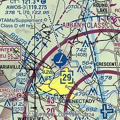
| Sectional chart |
|---|
|
CAUTION: Diagram may not be current
 Download PDF
of official airport diagram from the FAA
| Airport distance calculator |
|---|
|
|
| Sunrise and sunset |
|---|
|
Times for 24-May-2026
| | Local
(UTC-4) | | Zulu
(UTC) |
|---|
| Morning civil twilight | | 04:52 | | 08:52 |
| Sunrise | | 05:26 | | 09:26 |
| Sunset | | 20:19 | | 00:19 |
| Evening civil twilight | | 20:53 | | 00:53 |
|
| Current date and time |
|---|
| Zulu (UTC) | 24-May-2026 04:48:31 |
|---|
| Local (UTC-4) | 24-May-2026 00:48:31 |
|---|
|
| METAR |
|---|
| KSCH | 240048Z 11006KT 10SM -RA BKN009 BKN012 OVC090 10/09 A3048 RMK LAST
|
KALB
8nm SE | 240351Z 11004KT 10SM OVC070 10/08 A3048 RMK AO2 DZE48 SLP322 P0000 T01000083 $
|
KNY0
20nm NW | 240435Z AUTO 07006KT 10SM BKN008 OVC016 07/07 A3044 RMK AO2 P0001 T00740071
|
|
| TAF |
|---|
KALB
8nm SE | 232158Z 2322/2418 15009KT 5SM -RA BR OVC070 PROB30 2322/2324 6SM -SHRA BR OVC070 FM240000 16008KT 5SM -RA BR SCT015 OVC060 FM240900 15010KT 3SM RA BR SCT007 OVC010
|
|
| NOTAMs |
|---|
NOTAMs are issued by the DoD/FAA and will open in a separate window not controlled by AirNav.
|
|


