FAA INFORMATION EFFECTIVE 14 MAY 2026
Location
| FAA Identifier: | ADT |
| Lat/Long: | 39-50-25.2186N 101-02-32.9385W
39-50.420310N 101-02.548975W
39.8403385,-101.0424829
(estimated) |
| Elevation: | 2990.7 ft. / 911.6 m (surveyed) |
| Variation: | 06E (2020) |
| From city: | 2 miles N of ATWOOD, KS |
| Time zone: | UTC -5 (UTC -6 during Standard Time) |
| Zip code: | 67730 |
Airport Operations
| Airport use: | Open to the public |
| Activation date: | 12/1946 |
| Control tower: | no |
| ARTCC: | DENVER CENTER |
| FSS: | WICHITA FLIGHT SERVICE STATION |
| NOTAMs facility: | ICT (NOTAM-D service available) |
| Attendance: | UNATNDD |
| Wind indicator: | lighted |
| Segmented circle: | yes |
| Lights: | ACTVT REIL RWY 17 & 35; PAPI RWYS RWY 17 & 35; MIRL RWY 17/35 - CTAF. |
| Beacon: | white-green (lighted land airport)
Operates sunset to sunrise. |
Airport Communications
| CTAF/UNICOM: | 122.7 |
| WX AWOS-3: | 118.675 (785-626-3572) |
- APCH/DEP CTL SVC PRVDD BY DENVER ARTCC (ZDV) ON FREQS 132.7/226.675 (GOODLAND RCAG).
Nearby radio navigation aids
| VOR radial/distance | | VOR name | | Freq | | Var |
|---|
| MCKr215/30.0 | | MC COOK VOR/DME | | 115.30 | | 08E |
| HCTr177/37.2 | | HAYES CENTER VORTAC | | 117.70 | | 11E |
Airport Services
| Fuel available: | 100LL
100LL:24 HR SELF-SERVE FUEL. |
| Parking: | hangars and tiedowns |
| Bottled oxygen: | NONE |
| Bulk oxygen: | NONE |
Runway Information
Runway 17/35
| Dimensions: | 5000 x 75 ft. / 1524 x 23 m |
| Surface: | asphalt, in good condition |
| Weight bearing capacity: | | Single wheel: | 12.5 | | Double wheel: | 12.5 |
|
| Runway edge lights: | medium intensity |
| RUNWAY 17 | | RUNWAY 35 |
| Latitude: | 39-50.894647N | | 39-50.077330N |
| Longitude: | 101-02.659207W | | 101-02.530767W |
| Elevation: | 2990.7 ft. | | 2926.7 ft. |
| Traffic pattern: | left | | left |
| Runway heading: | 167 magnetic, 173 true | | 347 magnetic, 353 true |
| Markings: | nonprecision, in good condition | | nonprecision, in good condition |
| Visual slope indicator: | 2-light PAPI on left (3.00 degrees glide path) | | 2-light PAPI on right (3.00 degrees glide path) |
| Runway end identifier lights: | yes | | yes |
| Touchdown point: | yes, no lights | | yes, no lights |
Runway 4/22
| Dimensions: | 2400 x 100 ft. / 732 x 30 m |
| Surface: | turf, in good condition
ACUTE DIFFERENCE IN SFC ELEV AT INT WITH RWY 17 & 35. SUG OPS BE CONDUCTED E OF THAT INT. |
| RUNWAY 4 | | RUNWAY 22 |
| Latitude: | 39-50.144942N | | 39-50.422017N |
| Longitude: | 101-02.635977W | | 101-02.270257W |
| Elevation: | 2929.5 ft. | | 2946.3 ft. |
| Traffic pattern: | left | | left |
| Runway heading: | 040 magnetic, 046 true | | 220 magnetic, 226 true |
| Markings: | none, in fair condition | | none, in fair condition |
| Touchdown point: | yes, no lights | | yes, no lights |
| Obstructions: | 28 ft. pline, marked, 950 ft. from runway, 33:1 slope to clear | | none |
Airport Ownership and Management from official FAA records
| Ownership: | Publicly-owned |
| Owner: | CITY OF ATWOOD & RAWLINS CO.
ATWOOD, KS 67730
Phone 785-626-3344 |
| Manager: | KEVIN WORTHY
12323 HWY 25
ATWOOD, KS 67730
Phone 785-626-3344 |
Additional Remarks
| - | PUBLIC PHONE AVBL 24 HRS. |
| - | FOR CD CTC DENVER ARTCC AT 303-651-4257. |
Instrument Procedures
NOTE: All procedures below are presented as PDF files. If you need a reader for these files, you should download the free Adobe Reader.NOT FOR NAVIGATION. Please procure official charts for flight.
FAA instrument procedures published for use from 14 May 2026 at 0901Z to 11 June 2026 at 0900Z.
IAPs - Instrument Approach Procedures |
|---|
| RNAV (GPS) RWY 17 **CHANGED** | |
download (238KB) |
| NOTE: Special Take-Off Minimums/Departure Procedures apply **CHANGED** | |
download (360KB) |
Other nearby airports with instrument procedures:
KOIN - Oberlin Municipal Airport (23 nm E)
KCBK - Shalz Field Airport (25 nm S)
KMCK - Mc Cook Ben Nelson Regional Airport (30 nm NE)
KSYF - Cheyenne County Municipal Airport (35 nm W)
KGLD - Renner Field/Goodland Municipal Airport (41 nm SW)
|
|

Road maps at:
MapQuest
Bing
Google
| Aerial photo |
|---|
WARNING: Photo may not be current or correct
 Photo taken 05-Jul-2013
looking south.
Photo taken 05-Jul-2013
looking south.
Do you have a better or more recent aerial photo of Atwood/Rawlins County Airport that you would like to share? If so, please send us your photo.
|
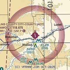
| Sectional chart |
|---|
|
| Airport distance calculator |
|---|
|
|
| Sunrise and sunset |
|---|
|
Times for 19-May-2026
| | Local
(UTC-5) | | Zulu
(UTC) |
|---|
| Morning civil twilight | | 05:56 | | 10:56 |
| Sunrise | | 06:27 | | 11:27 |
| Sunset | | 20:55 | | 01:55 |
| Evening civil twilight | | 21:25 | | 02:25 |
|
| Current date and time |
|---|
| Zulu (UTC) | 19-May-2026 08:57:03 |
|---|
| Local (UTC-5) | 19-May-2026 03:57:03 |
|---|
|
| METAR |
|---|
| KADT | 190835Z AUTO 35007KT 10SM BKN024 07/02 A3020 RMK AO2 T00660020
|
|
| TAF |
|---|
KMCK
30nm NE | 190555Z 1906/2006 36012G19KT P6SM BKN025 TEMPO 1908/1912 36008KT BKN035 FM191200 35012KT P6SM SCT035 FM191600 35013KT P6SM FEW220 FM191800 36007KT P6SM SCT220
|
|
| NOTAMs |
|---|
NOTAMs are issued by the DoD/FAA and will open in a separate window not controlled by AirNav.
|
|

