FAA INFORMATION EFFECTIVE 25 DECEMBER 2025
Location
| FAA Identifier: | MCK |
| Lat/Long: | 40-12-22.6520N 100-35-31.5380W
40-12.377533N 100-35.525633W
40.2062922,-100.5920939
(estimated) |
| Elevation: | 2582.9 ft. / 787.3 m (surveyed) |
| Variation: | 08E (1995) |
| From city: | 2 miles E of MC COOK, NE |
| Time zone: | UTC -6 (UTC -5 during Daylight Saving Time) |
| Zip code: | 69001 |
Airport Operations
| Airport use: | Open to the public |
| Activation date: | 05/1946 |
| Control tower: | no |
| ARTCC: | DENVER CENTER |
| FSS: | COLUMBUS FLIGHT SERVICE STATION |
| NOTAMs facility: | MCK (NOTAM-D service available) |
| Attendance: | DAYLIGHT HOURS |
| Wind indicator: | lighted |
| Segmented circle: | yes |
| Lights: | ACTVT VASI RY 30 & PAPI RY 12 & MALSR RY 12 - CTAF. |
| Beacon: | white-green (lighted land airport)
Operates sunset to sunrise. |
| Fire and rescue: | ARFF index A |
Airport Communications
| CTAF/UNICOM: | 122.8 |
| WX ASOS: | 119.025 (308-345-1193) |
- APCH/DEP CTL SVC PRVDD BY DENVER ARTCC (ZDV) ON FREQS 132.7/226.675 (NORTH PLATTE RCAG).
Nearby radio navigation aids
| VOR radial/distance | | VOR name | | Freq | | Var |
|---|
| MCK at field | | MC COOK VOR/DME | | 115.30 | | 08E |
| HCTr123/21.2 | | HAYES CENTER VORTAC | | 117.70 | | 11E |
| NDB name | | Hdg/Dist | | Freq | | Var | | ID |
|---|
| OBERLIN | | 348/22.7 | | 341 | | 06E | | OIN | --- .. -. |
Airport Services
| Fuel available: | 100LL JET-A |
| Parking: | hangars and tiedowns |
| Airframe service: | MAJOR |
| Powerplant service: | MAJOR |
| Bottled oxygen: | NONE |
| Bulk oxygen: | NONE |
Runway Information
Runway 12/30
| Dimensions: | 6450 x 100 ft. / 1966 x 30 m |
| Surface: | concrete, in good condition |
| Weight bearing capacity: | | Single wheel: | 30.0 | | Double wheel: | 38.0 |
|
| Runway edge lights: | medium intensity |
| RUNWAY 12 | | RUNWAY 30 |
| Latitude: | 40-12.749625N | | 40-12.046303N |
| Longitude: | 100-35.956237W | | 100-34.918247W |
| Elevation: | 2582.9 ft. | | 2542.0 ft. |
| Traffic pattern: | left | | right |
| Runway heading: | 123 magnetic, 131 true | | 303 magnetic, 311 true |
| Displaced threshold: | no | | 750 ft. |
| Declared distances: | TORA:6448 TODA:6448 ASDA:5698 LDA:5698 | | TORA:6448 TODA:6448 ASDA:6448 LDA:5698 |
| Markings: | precision, in fair condition | | nonprecision, in fair condition |
| Visual slope indicator: | 4-light PAPI on left (3.00 degrees glide path)
UNUSBL BYD 5 DEGS RIGHT OF CNTRLN AND 8 DEGS LEFT OF CNTRLN. | | 4-box VASI on left (3.00 degrees glide path) |
| Approach lights: | MALSR: 1,400 foot medium intensity approach lighting system with runway alignment indicator lights | | |
| Runway end identifier lights: | | | yes |
| Touchdown point: | yes, no lights | | yes, no lights |
| Instrument approach: | ILS/DME | | |
| Obstructions: | 30 ft. tree, 1225 ft. from runway, 475 ft. left of centerline, 34:1 slope to clear | | none |
Runway 4/22
| Dimensions: | 4000 x 75 ft. / 1219 x 23 m |
| Surface: | concrete, in good condition |
| Weight bearing capacity: | | Single wheel: | 30.0 | | Double wheel: | 38.0 |
|
| Runway edge lights: | medium intensity |
| RUNWAY 4 | | RUNWAY 22 |
| Latitude: | 40-12.167597N | | 40-12.625695N |
| Longitude: | 100-35.978955W | | 100-35.361583W |
| Elevation: | 2562.6 ft. | | 2555.6 ft. |
| Traffic pattern: | right | | left |
| Runway heading: | 038 magnetic, 046 true | | 218 magnetic, 226 true |
| Declared distances: | TORA:4000 TODA:4000 ASDA:4000 LDA:4000 | | TORA:4000 TODA:4000 ASDA:4000 LDA:4000 |
| Markings: | nonprecision, in fair condition | | nonprecision, in fair condition |
| Visual slope indicator: | 2-box VASI on left (3.00 degrees glide path) | | 2-box VASI on left (3.00 degrees glide path) |
| Touchdown point: | yes, no lights | | yes, no lights |
| Obstructions: | 25 ft. pole, 850 ft. from runway, 100 ft. left of centerline, 26:1 slope to clear | | none |
Runway 17/35
| Dimensions: | 1330 x 160 ft. / 405 x 49 m |
| Surface: | turf, in fair condition |
| Runway edge markings: | 17/35 THR BDRY MKRS. |
| Operational restrictions: | RWY 17/35 NOT AVBL FOR PART 121/PART 380 OPS WITH SKED PAX CARRYING OPS MORE THAN 9 PAX SEATS AND NON-SKED PAX CARRYING OPS MORE THAN 30 PAX SEATS. |
| RUNWAY 17 | | RUNWAY 35 |
| Latitude: | 40-12.330293N | | 40-12.111387N |
| Longitude: | 100-35.515763W | | 100-35.522995W |
| Elevation: | 2558.0 ft. | | 2561.3 ft. |
| Traffic pattern: | left | | right |
| Runway heading: | 173 magnetic, 181 true | | 353 magnetic, 001 true |
| Touchdown point: | yes, no lights | | yes, no lights |
Airport Ownership and Management from official FAA records
| Ownership: | Publicly-owned |
| Owner: | CITY OF MC COOK
BOX 1059
MC COOK, NE 69001
Phone 308-345-2022 |
| Manager: | MR. NATE SCHNEIDER
BOX 1059
MC COOK, NE 69001
Phone 308-345-2022
CITY MANAGER. |
Additional Remarks
| A39-12/30 | PCR VALUE: 90/R/B/W/T |
| A39-04/22 | PCR VALUE: 90/R/B/W/T |
| - | FOR CD CTC DENVER ARTCC ON FREQ. IF UNA, CTC FSS ON FREQ VIA RCO. IF UNA, CTC DENVER ARTCC AT 303-651-4257. |
| - | ACTVT MALSR RWY 12; PAPI RWY 12; & VASI RWY 30 - CTAF. |
Instrument Procedures
NOTE: All procedures below are presented as PDF files. If you need a reader for these files, you should download the free Adobe Reader.NOT FOR NAVIGATION. Please procure official charts for flight.
FAA instrument procedures published for use from 25 December 2025 at 0901z to 22 January 2026 at 0900z.
IAPs - Instrument Approach Procedures |
|---|
| ILS OR LOC/DME RWY 12 | |
download (263KB) |
| RNAV (GPS) RWY 12 | |
download (288KB) |
| RNAV (GPS) RWY 22 | |
download (228KB) |
| RNAV (GPS) RWY 30 | |
download (239KB) |
| VOR RWY 30 | |
download (215KB) |
| NOTE: Special Alternate Minimums apply | |
download (146KB) |
| NOTE: Special Take-Off Minimums/Departure Procedures apply | |
download (147KB) |
Other nearby airports with instrument procedures:
KCSB - Cambridge Municipal Airport (21 nm E)
KOIN - Oberlin Municipal Airport (22 nm S)
47V - Curtis Municipal Airport (27 nm N)
KADT - Atwood-Rawlins County City-County Airport (30 nm SW)
KNRN - Norton Municipal Airport (39 nm SE)
|
|

Road maps at:
MapQuest
Bing
Google
| Aerial photo |
|---|
WARNING: Photo may not be current or correct
 Photo by David Newcomer
Photo taken 01-Apr-2012
from 3,000' AGL looking north.
Photo by David Newcomer
Photo taken 01-Apr-2012
from 3,000' AGL looking north.
Do you have a better or more recent aerial photo of Mc Cook Ben Nelson Regional Airport that you would like to share? If so, please send us your photo.
|
| Sectional chart |
|---|
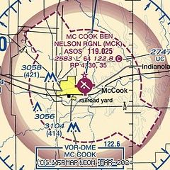
|
CAUTION: Diagram may not be current

| Airport distance calculator |
|---|
|
|
| Sunrise and sunset |
|---|
|
Times for 04-Jan-2026
| | Local
(UTC-6) | | Zulu
(UTC) |
|---|
| Morning civil twilight | | 07:36 | | 13:36 |
| Sunrise | | 08:06 | | 14:06 |
| Sunset | | 17:29 | | 23:29 |
| Evening civil twilight | | 17:59 | | 23:59 |
|
| Current date and time |
|---|
| Zulu (UTC) | 04-Jan-2026 14:29:47 |
|---|
| Local (UTC-6) | 04-Jan-2026 08:29:47 |
|---|
|
| METAR |
|---|
| KMCK | 041353Z AUTO 24004KT 10SM CLR 02/00 A2976 RMK AO2 SLP086 T00220000
|
|
| TAF |
|---|
| KMCK | 041120Z 0412/0512 19007KT P6SM SCT220 FM041700 30011KT P6SM SCT220 TEMPO 0417/0421 32014G20KT FM042300 VRB06KT P6SM FEW220
|
|
| NOTAMs |
|---|
NOTAMs are issued by the DoD/FAA and will open in a separate window not controlled by AirNav.
|
|


