FAA INFORMATION EFFECTIVE 14 MAY 2026
Location
| FAA Identifier: | OIN |
| Lat/Long: | 39-50-03.7840N 100-32-23.4030W
39-50.063067N 100-32.390050W
39.8343844,-100.5398342
(estimated) |
| Elevation: | 2706.8 ft. / 825.0 m (surveyed) |
| Variation: | 06E (2015) |
| From city: | 1 mile NW of OBERLIN, KS |
| Time zone: | UTC -5 (UTC -6 during Standard Time) |
| Zip code: | 67749 |
Airport Operations
| Airport use: | Open to the public |
| Activation date: | 09/1945 |
| Control tower: | no |
| ARTCC: | DENVER CENTER |
| FSS: | WICHITA FLIGHT SERVICE STATION |
| NOTAMs facility: | ICT (NOTAM-D service available) |
| Attendance: | DAWN-DUSK |
| Wind indicator: | lighted |
| Segmented circle: | yes |
| Lights: | ACTVT MIRL RWY 17/35 - CTAF. |
| Beacon: | white-green (lighted land airport)
Operates sunset to sunrise. |
Airport Communications
| CTAF/UNICOM: | 122.8 |
| WX AWOS-3PT: | 119.225 (785-470-4236) |
- APCH/DEP CTL SVC PRVDD BY DENVER ARTCC (ZDV) ON FREQS 132.7/226.675 (GOODLAND RCAG).
Nearby radio navigation aids
| VOR radial/distance | | VOR name | | Freq | | Var |
|---|
| MCKr166/22.3 | | MC COOK VOR/DME | | 115.30 | | 08E |
| HLCr329/37.5 | | HILL CITY VORTAC | | 113.70 | | 08E |
Airport Services
| Fuel available: | 100LL |
| Parking: | hangars and tiedowns |
| Airframe service: | MAJOR |
| Powerplant service: | MAJOR |
Runway Information
Runway 17/35
| Dimensions: | 4301 x 60 ft. / 1311 x 18 m |
| Surface: | asphalt, in good condition |
| Weight bearing capacity: | |
| Runway edge lights: | medium intensity |
| RUNWAY 17 | | RUNWAY 35 |
| Latitude: | 39-50.458787N | | 39-49.750580N |
| Longitude: | 100-32.405603W | | 100-32.413077W |
| Elevation: | 2706.8 ft. | | 2667.2 ft. |
| Traffic pattern: | left | | left |
| Runway heading: | 174 magnetic, 180 true | | 354 magnetic, 000 true |
| Displaced threshold: | no | | 800 ft. |
| Declared distances: | TORA:3501 TODA:4301 ASDA:4301 LDA:4301 | | TORA:4301 TODA:4301 ASDA:4301 LDA:3501 |
| Markings: | nonprecision, in good condition | | nonprecision, in good condition |
| Visual slope indicator: | 2-light PAPI on left (3.00 degrees glide path) | | 2-light PAPI on left (3.00 degrees glide path) |
| Touchdown point: | yes, no lights | | yes, no lights |
Runway 12/30
| Dimensions: | 2832 x 130 ft. / 863 x 40 m |
| Surface: | turf, in fair condition |
| RUNWAY 12 | | RUNWAY 30 |
| Latitude: | 39-50.165490N | | 39-49.834265N |
| Longitude: | 100-32.573662W | | 100-32.147853W |
| Elevation: | 2683.0 ft. | | 2648.5 ft. |
| Traffic pattern: | left | | left |
| Runway heading: | 129 magnetic, 135 true | | 309 magnetic, 315 true |
| Touchdown point: | yes, no lights | | yes, no lights |
| Obstructions: | none | | 26 ft. trees, lighted, 205 ft. from runway, 125 ft. right of centerline
CTLG OBSTN EXCEEDS 45 DEG SLP. |
Airport Ownership and Management from official FAA records
| Ownership: | Publicly-owned |
| Owner: | CITY OF OBERLIN
1 MORGAN DR
OBERLIN, KS 67749 |
| Manager: | BRICE MEITL
1 MORGAN DR
OBERLIN, KS 67749
Phone 785-470-0019 |
Additional Remarks
| - | FOR CD CTC DENVER ARTCC AT 303-651-4257. |
Instrument Procedures
NOTE: All procedures below are presented as PDF files. If you need a reader for these files, you should download the free Adobe Reader.NOT FOR NAVIGATION. Please procure official charts for flight.
FAA instrument procedures published for use from 14 May 2026 at 0901Z to 11 June 2026 at 0900Z.
IAPs - Instrument Approach Procedures |
|---|
| RNAV (GPS) RWY 17 | |
download (189KB) |
| RNAV (GPS) RWY 35 | |
download (193KB) |
| NOTE: Special Alternate Minimums apply | |
download (147KB) |
| NOTE: Special Take-Off Minimums/Departure Procedures apply | |
download (351KB) |
Other nearby airports with instrument procedures:
KMCK - Mc Cook Ben Nelson Regional Airport (22 nm N)
KADT - Atwood/Rawlins County Airport (23 nm W)
KNRN - Norton Municipal Airport (30 nm E)
KCSB - Cambridge Municipal Airport (33 nm NE)
KCBK - Shalz Field Airport (34 nm SW)
|
|

Road maps at:
MapQuest
Bing
Google
| Aerial photo |
|---|
WARNING: Photo may not be current or correct
 Photo by Von Rothenberger
Photo taken 23-Jul-2006
from about 6000 ft MSL
Photo by Von Rothenberger
Photo taken 23-Jul-2006
from about 6000 ft MSL
Do you have a better or more recent aerial photo of Oberlin Municipal Airport that you would like to share? If so, please send us your photo.
|
| Sectional chart |
|---|
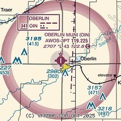
|
| Airport distance calculator |
|---|
|
|
| Sunrise and sunset |
|---|
|
Times for 04-Jun-2026
| | Local
(UTC-5) | | Zulu
(UTC) |
|---|
| Morning civil twilight | | 05:44 | | 10:44 |
| Sunrise | | 06:16 | | 11:16 |
| Sunset | | 21:05 | | 02:05 |
| Evening civil twilight | | 21:37 | | 02:37 |
|
| Current date and time |
|---|
| Zulu (UTC) | 04-Jun-2026 22:48:43 |
|---|
| Local (UTC-5) | 04-Jun-2026 17:48:43 |
|---|
|
| METAR |
|---|
| KOIN | 042235Z AUTO 17006KT 140V230 10SM CLR 29/17 A2984 RMK AO2
|
|
| TAF |
|---|
KMCK
22nm N | 041751Z 0418/0518 15003KT P6SM BKN025 TEMPO 0418/0419 BKN035 FM041900 17008KT P6SM BKN035 FM050500 17010KT P6SM SCT250 WS010/20040KT FM051000 20010KT P6SM SKC
|
|
| NOTAMs |
|---|
NOTAMs are issued by the DoD/FAA and will open in a separate window not controlled by AirNav.
|
|

